EASyQuart
News

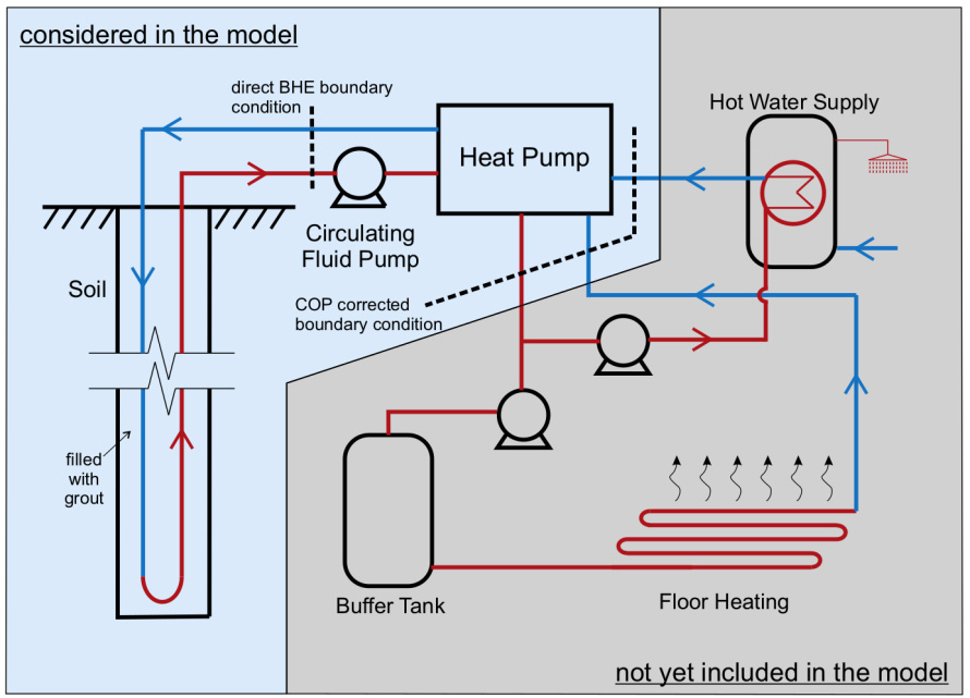
 Schematic representation of a model for the operation of a borehole heat exchanger, coupled with a heat pump system for thermal building supply (Zheng et al., 2016)
Project title: Energieeffiziente Auslegung und Planung dezentraler Versorgungsnetze zum Heizen und Kühlen von Stadtquartieren unter Nutzung des oberflächennahen geologischen Raumes
(Project title – English translation: Energy-efficient design and planning of decentralised supply networks for heating and cooling of urban areas using the shallow subsurface)
Short project description:
Urban areas and large building complexes will increasingly play a key role in the process of the energy transition and in achieving climate protection goals. The reason for this is their great efficiency potential in the supply of thermal energy, which, according to the German Environment Agency, accounts for almost 51% of Germany's final energy consumption, such as electricity and mobility sector in total and has only recently become the focus of transformation measures for energy sources and increases in energy efficiency.
The shallow subsurface offers a base load capable thermal potential for the urban heat energy supply. In Germany, this potential is usually exploited using heat pumps. As a result, the optimised operation of ground-based heat pump systems is crucial for low primary energy consumption and the economically and ecologically sustainable use of geothermal resources.
Extensive experience and a wide range of literature are available for the optimisation of individual borehole heat exchanger systems (BHE). The current design practice for large-scale BHEs is based primarily on the same documents (guidelines, directives, etc.) and regulatory framework conditions that were created for the planning of individual systems. Thus, neighbourhood solutions are required that allow both optimised system dimensioning and efficient as well as sustainable operation of the systems.
The aim of the joint project EASyQuart is the development of a site-based decision support system for heating and cooling of urban areas using shallow geothermal resources. The decision support system is to be understood as a guideline for action in the design process, which formulates optimised structures, which actor should be active at which point in time depending on the specific site conditions using which instruments. The project results include the development and extension of workflows, evaluation criteria and practical scientific instruments that go beyond the instruments used in the current design practice, and which are intended to help to prevent economically disadvantageous oversizing or undersizing of the considered systems. Based on expected results, the design procedures, regulatory framework and business models are to be made more flexible in the form of recommendations for action.
Improved instruments are introduced in the area of innovative methods for exploration and monitoring in the underground and of building services, numerical simulation of subsurface processes and building services components of the energy systems under consideration as well as integrated 3D visualisation in the decision support system. Analyses at demonstration sites are used to parameterise simulation models and to evaluate individual project results. The innovation of the project idea consists in the development of instruments for the site-based analysis of the supply and demand side, including their validation with site data, and offers commercial users and public authorities support in the prediction of the economic efficiency of usage options of the shallow subsurface for heating and cooling from individual buildings to urban areas.
Project duration: 10/19 – 09/22
Funding organisation: BMWi

Project partners:
- geoENERGIE Konzept GmbH Freiberg
- Helmholtz Centre for Environmental Research – UFZ
- Leipzig University of Applied Sciences (HTWK) – coordinator
At the UFZ, research for this project is also being conducted at the Department Monitoring and Exploration Technologies.
At the Department of Environmental Informatics, research for this project is being conducted at the workgroup Geothermal Systems Analysis.
Project website: www.ufz.de/easyquart
This research was also part of the OpenGeoSys initiative (www.opengeosys.org).
