MoDEV

Towards novel Model-Data fusion for understanding Environmental Variability in space and time from high-resolution remote sensing

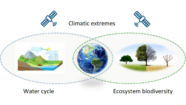
Drought and heat extremes normally last for short periods of time (days to weeks), but their lagged impacts on ecosystems can last for multiple years, e.g. if there is large-scale die-off (Anderegg et al., 2015). These extremes are manifested also in alterations of the terrestrial water and energy cycles and are thereby observable in reduced soil moisture and runoff as well as increased evapotranspiration (Samaniego et al., 2018; Teuling et al., 2013; Yin et al., 2018). However, understanding the exact feedbacks between climate extremes and ecosystem functioning across different temporal and spatial scales remains a grand challenge. Satellite remote sensing of environmental variables can provide observational evidence of extreme event dynamics in terrestrial ecosystems at large scales (Mahecha et al. 2017). Currently, there are still large uncertainties in the Earth System Model for simulating water and carbon cycles at different spatial and temporal scales. Satellite remote sensing products offer unprecedented constraints for the Earth System Model to better represent the water–carbon coupling process.
Key questions
- How can we assess biodiversity from (multi-)spectral data for a quantification of ecosystem changes?
- How can water cycle dynamics (e.g., soil moisture, evapotranspiration) be accurately quantified during climate extremes?
- What are the physical processes that determine different responses of ecosystems to climate extremes?
- How can we integrate multi-source data and modeling framework to solve scale issues and uncertainties traceability?
- Can we parameterize the ‘observed’ processes and predict future changes in ecosystem-climatic extreme interactions?
Research context and knowledge gaps
To better understand water cycle and ecosystem interactions with climate extremes, a quantitative assessment of the interactions among feedback processes, their consequences across spatial and temporal scales, and the atmospheric teleconnections that link changes occurring in different regions are required. Assessments of this kind also require an understanding of land surface heterogeneity, i.e. structural and functional biodiversity as key mediators of climate signals on ecosystem functions. In many cases, these indicators can be retrieved from remote sensing data. However, the temporal and spatial resolutions of current satellite-derived products are not yet sufficiently matured for many of the involved quantification steps (e.g. Lausch et al. 2016). At first glance, the high-resolution Sentinel data seem apt to fill this gap. However, major challenges are the lack of a long-term reference periods (Sentinel data are only available since 1–5 years, depending on the data products) and suitable algorithms to jointly extract high-resolution, internal-consistent, and quality assured environmental variables and ecosystem properties from the different Sentinels (1, 2, 3). Novel model–data fusion concepts are needed to integrate radiative transfer models, data assimilation and machine learning methods, as well as multi-source remote sensing data to address this challenge. Novel satellite-based LAI, leaf chlorophyll concentration, leaf moisture content, evapotranspiration, soil moisture, vegetation structural parameters, as well as biodiversity and disturbance indicators are critical to better understand the occurrence and impacts of climate extremes on ecosystems across scales. Still, when it comes to a remotely-sensed biodiversity assessment, many fundamental relationships are still underexplored to allow for an operational retrieval of indicators from Earth observation data (Lausch et al. 2016). A fusion of the aforementioned approaches is likewise promising to provide new insights to address these knowledge gaps. Furthermore, the advanced process understanding could be applied to improve the ecosystem water–energy coupling schemes in the Earth System Model, which will lead to better predictions of water and carbon cycles.
Collaboration and integration
The PhD consortium MoDEV is an interdisciplinary research platform that combines deep domain knowledge in the areas of terrestrial ecology, hydrology, and climate sciences with remote sensing, modeling and data sciences techniques. The integration of multi-source Earth observations and modeling framework will bridge the spatial scales from the field level to the regional and even global scales. On the one hand, existing data collected from airborne campaigns (MOSES, TERENO, ICOS and eLTER) will be analyzed and used to evaluate newly developed satellite products. On the other hand, water and carbon fluxes from MOSES, TERENO, and ICOS stations will be directly used to investigate water-carbon coupling under extreme events. Improved process understanding based on such in-situ data will form the basis for interpreting newly developed satellite products, which itself will be used to improve process based mHM and FORMIND models to better simulate water and carbon cycles at various time and spatial scales. In addition, the developed new satellite products and modeling framework will be transferred to UFZ Data Management Team to facilitate access, use, interpretation, and visualization of these data products. Further collaboration with the visualization center is foreseen to display the generated satellite and model-based datasets in dynamics 3D animations for the wider public.
Outline of the project
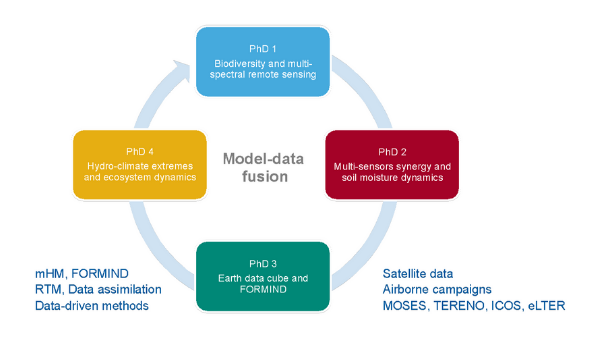
Satellite remote sensing provides new tools to help us to better understand spatial and temporal dynamics in terrestrial ecosystems across scales. In particular, the integration of modeling approaches and multi-source Earth observations is essential to quantitatively assess the interactions between climate extremes, ecosystem functioning, and water cycle dynamics at various temporal and spatial scales. The four PhD projects are interconnected and aim to apply novel model–data fusion concepts to provide observational evidence of environmental variability based on high-resolution satellite data, and disentangle complex interactions between vegetation and water dynamics under climate extremes. PhD 1 focuses on derivation of ecosystem biodiversity indicators based on high-resolution Sentinel-2 data, while PhD 2 develops high-resolution surface and root-zone soil moisture from Sentinel-1 and Cosmic-Ray Neutron Sensing (CRNS) measurements. PhD 3 concentrates on the integration of the Earth system data cube concept, the FORMIND and LPJ models to investigate land surface dynamics in tropics under extremes. PhD 4 develops novel methods to investigate the role of land–atmosphere feedback on the occurrence of extremes and their interactions with different ecosystems based on multi-source data and newly developed products from PhD 1 and 2.

PhD student:
Antonia Ludwig (RS)
Supervising team:
Prof. Dr. Hannes Feilhauer (RSC4Earth)
,
Dr. Daniel Doktor (RS)
In times of rapid climate warming and the associated impacts on the Earth's ecosystems, continuous and timely determination of plant diversity plays a crucial role in the context of land management and future strategies. Remote sensing methods are already widely used to assess the diversity of plants and their traits, which are crucial for ecosystem functions. The use of remotely sensed data enables researchers to track changes in species populations over large areas and over long periods of time.
A frequently discussed approach is the evaluation of spectral variation between individual image pixels. It is based on the assumption that the variability in the reflectance of neighboring pixels in caused by heterogeneous soil conditions and/or specific differences in the combinations of leaf and crown properties of the imaged plant communities. In both cases, heterogeneity in the spectral range would allow to draw conclusions about heterogeneous species compositions. In the sense of the so-called "spectral variation hypothesis" (SVH), a high spectral variability is thus used as an indicator for particularly diverse vegetation types.
Although the described approach appears intuitive and practicable, it has not been systematically tested to date. Previous studies referred only correlatively to individual ecosystems. Moreover, different spatial resolutions and seasonal variations in plant phenology were further neglected in these studies. Thus, the main drivers of spectral variation as well as their dependence on e.g. the sensor system or the time of the vegetation period remain unexplained until today.
PhD Project 1 aims at closing this gap and at systematically investigating the spectral variation hypothesis. A combined approach of field work (incl extensive trait sampling) with simulation and modeling techniques (e.g. RTMs) allows a systematic investigation of the postulated relationships and provides insights into the driving forces of spectral variation. The knowledge gained from this should lead to methodological developments that make it possible to classify the HNV-status ("high nature value") of various areas in Germany based on Sentinel-2 image data.
PhD student:
Toni Schmidt (RS)
Supervising team:
Prof. Dr. Jian Peng (RS)
,
Dr. Martin Schrön (MET)
Soil moisture is an essential component of the Earth system. It plays a critical role in the exchange of water, energy, and biogeochemical fluxes between the atmosphere and the land surface. Currently, there are several microwave-based soil moisture products at coarse spatial resolution (around 25–50 km) available on the global scale. However, to be able to service the wide range of applications such as applied hydrology, precision agriculture, disaster prevention, Numerical Weather Prediction, evaporation estimation, and climate monitoring, there is a strong need for higher resolution (0.1–1 km) soil moisture products. Current and future satellite missions (e.g., Sentinel-1, SAOCOM, NISAR, Tandem-L) will provide opportunities to develop high-resolution soil moisture products. The soil moisture retrieval approaches are normally limited to single sensors. The satellite data from different sensors in microwave, optical, and thermal domains provide complementary information on the state of the surface. However, it is challenging to retrieve soil moisture from multi-spectral and multi-temporal data due to the lack of robust methods that can integrate complementary information from different sensors across multi-temporal and spatial scales. In addition, the satellite soil moisture can only represent the water in the upper soil layer. Several root-zone soil moisture products at coarse resolution have been produced based on exponential filtering to mimic the infiltration, or assimilation of the satellite soil moisture into land surface models. Nevertheless, the generation of high-resolution root-zone soil moisture still needs to be investigated. To address these challenges, the PhD project aims to investigate the integrated optimal retrieval framework to retrieve soil moisture dynamics via the synergy use of multi-source data. The framework will be tested at site scales and applied to develop regional soil moisture products with quantified uncertainty information. In addition, the root-zone soil moisture will be estimated through the integration of the retrieved satellite surface soil moisture, land surface model and Cosmic-Ray Neutron Sensing (CRNS).
PhD student:
Kim Schmidt (RS, OESA)
Supervising team:
Prof. Dr. Miguel D. Mahecha (RSC4Earth)
,
Prof. Dr. Andreas Huth (OESA)
Forest ecosystems play an important role in regulating the regional water cycle and global carbon dynamics. At the same time these ecosystems are under severe anthropogenic pressure e.g. due to massive land-use and climate change. To anticipate the consequences of such transformations we need to understand the fundamental ecosystem dynamics in forest ecosystems.
However, remote sensing has made progress and e.g. more accurate Solar Induced Fluorescence data, estimates of Gross Primary Production, and estimates of Vertical Optical Depth can now reveal spatiotemporal dynamics. Latest data-cube approaches make it very efficiently possible to jointly explore big gridded data of this kind as data cubes. From a modeling point of view, the forest model FORMIND, an individual-based model is now able to model e.g. the entire Amazon basin and represent the full spatial heterogeneity of the forest dynamics at very high spatial resolution. Dynamic Global Vegetation Models are apt to represent the temporal dynamics of the carbon and water cycles accurately.
What we miss, however, is bringing the spatiotemporal details of remote sensing data, with the accurate representation of specific processes in the models together and enable a joint interpretation of key processes that need to be investigated. In general, we have only a very limited understanding how emergent properties like e.g. the scaling behavior of extremes in the carbon cycle are manifested regionally. However, a basic representation and understanding of such processes in a key prerequisite for anticipating how anomalies propagate into large-scale patterns of interannual variability in global biogeochemical cycles.
PhD student:
Marco Hannemann (RS)
Supervising team:
Prof. Dr. Jian Peng (RS)
,
Prof. Dr. Miguel D. Mahecha (RSC4Earth)
Hydro-climatic extremes such as droughts and heat waves have devastating impacts on many
aspects of the ecosystem and socio-economic systems. There is a strong need to better understand and identify the driving mechanisms of extreme events, address their impacts on ecosystems, and project future changes. However, comprehensive analysis and interpretation of land-atmosphere interactions under climate extremes based on multi-source Earth observations are still incomplete. Remote sensing observations have been successfully used to develop consistent global historical records of crucial climatic and environmental variables (e.g., soil moisture, evaporation, water and carbon fluxes). These products have great potential to unravel the processes driving long-term changes of hydro-climatic extremes, and understand the impacts of these changes on terrestrial ecosystems. For example, the impacts of soil moisture on biosphere-atmosphere interaction during extreme events have been widely investigated. However, as the key variable in land-atmosphere interaction, the impacts and response of evaporation to climate extremes have not been fully exploited, due to the challenges in accurate estimation of evaporation. In particular, the partitioning transpiration from total evaporation remains highly uncertain. The aim of this PhD project is to systematically investigate the role of land-atmosphere feedback (essential variables) on the occurrence of extreme events (e.g., drought, heat wave) and their interactions with different ecosystems based on satellite observations, field data, and model simulations.
Further information
For PhD 1 (Assessment of species and trait diversity in temperate vegetation from optical remote sensing data) we work on the following study sites:
- Bad Lauchstädt, Saxony, Germany
- Luppeaue, Schkeuditz/Leipzig, Saxony, Germany
- NSG Lunzberge, Halle/Lettin, Saxony-Anhalt, Germany
For PhD 2 (Estimation of high-resolution soil moisture dynamics from the synergy of multi-source data) we work on sites of the COSMOS-Europe network (Bogena et al., 2022) and the
TERENO network
.
- EDA - Helmholtz Alliance “Remote Sensing and Earth System Dynamics”
- FLUXNET - eddy covariance flux measurements
- FORMIND – the forest model
- ICOS - Intergrated Carbon Observation System
- mHM - Mesoscale Hydrologic Model
- MOSES- observing system of the Helmholtz Association
- RSC4Earth – Remote Sensing Centre for Earth System Research
- TERENO - Terrestrial Environmental Observatories
- Anderegg, W. R. L., Schwalm, C., Biondi, F., Camarero, J. J., Koch, G., Litvak, M., Ogle, K., Shaw, J. D., Shevliakova, E., Williams, A. P., Wolf, A., Ziaco, E., and Pacala, S.: Pervasive drought legacies in forest ecosystems and their implications for carbon cycle models, Science, 349, 528–532, doi:10.1126/science.aab1833, 2015.
- Bogena, H. R., Schrön, M., Jakobi, J., Ney, P., Zacharias, S., Andreasen, M., Baatz, R., Boorman, D., Duygu, M. B., Eguibar-Galán, M. A., Fersch, B., Franke, T., Geris, J., González Sanchis, M., Kerr, Y., Korf, T., Mengistu, Z., Mialon, A., Nasta, P., Nitychoruk, J., Pisinaras, V., Rasche, D., Rosolem, R., Said, H., Schattan, P., Zreda, M., Achleitner, S., Albentosa-Hernández, E., Akyürek, Z., Blume, T., del Campo, A., Canone, D., Dimitrova-Petrova, K., Evans, J. G., Ferraris, S., Frances, F., Gisolo, D., Güntner, A., Herrmann, F., Iwema, J., Jensen, K. H., Kunstmann, H., Lidón, A., Looms, M. C., Oswald, S., Panagopoulos, A., Patil, A., Power, D., Rebmann, C., Romano, N., Scheiffele, L., Seneviratne, S., Weltin, G., and Vereecken, H.: COSMOS-Europe: a European network of cosmic-ray neutron soil moisture sensors, Earth System Science Data, 14, 1125–1151, doi:10.5194/essd-14-1125-2022, 2022.
- Lausch, A., Bannehr, L., Beckmann, M., Boehm, C., Feilhauer, H., Hacker, J. M., Heurich, M., Jung, A., Klenke, R., Neumann, C., Pause, M., Rocchini, D., Schaepman, M. E., Schmidtlein, S., Schulz, K., Selsam, P., Settele, J., Skidmore, A. K., and Cord, A. F.: Linking earth observation and taxonomic, structural and functional biodiversity: local to ecosystem perspectives, Ecological Indicators, 70, 317–339, doi:10.1016/j.ecolind.2016.06.022, 2016.
- Mahecha, M. D., Gans, F., Sippel, S., Donges, J. F., Kaminski, T., Metzger, S., Migliavacca, M., Papale, D., Rammig, A., and Zscheischler, J.: Detecting impacts of extreme events with ecological in-situ monitoring networks, Biogeosciences, 14, 4255–4277, doi:10.5194/bg-14-4255-2017, 2017.
- Samaniego, L., Thober, S., Kumar, R., Wanders, N., Rakovec, O., Pan, M., Zink, M., Sheffield, J., Wood, E. F., and Marx, A.: Anthropogenic warming exacerbates European soil moisture droughts, Nature Climate Change, 8, 421–426, doi:10.1038/s41558-018-0138-5, 2018.
- Teuling, A. J., Van Loon, A. F., Seneviratne, S. I., Lehner, I., Aubinet, M., Heinesch, B., Bernhofer, C., Grünwald, T., Prasse, H., and Spank, U.: Evapotranspiration amplifies European summer drought, Geophysical Research Letters, 40, 2071–2075, doi:10.1002/grl.50495, 2013.
- Yin, J., Gentine, P., Zhou, S., Sullivan, S. C., Wang, R., Zhang, Y., and Guo, S.: Large increase in global storm runoff extremes driven by climate and anthropogenic changes, Nature communications, 9, 1–10, doi:10.1038/s41467-018-06765-2, 2018.
