Linking Remote Sensing and Ecological Modelling

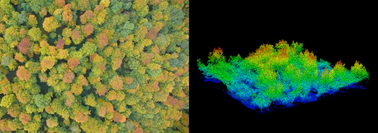
The target of this research topic is the development of new methods for the calculation of vegetation attributes by using remote sensing systems. The outcome should contribute to continuous coverage mapping of aboveground carbon stocks and other attributes in vegetation and their dynamics. The most important goal is gaining a better understanding of the following scientific questions:
- How can we obtain important forest attributes (aboveground biomass, leaf area, productivity, mortality, carbon fluxes) from remote sensing?
- How can we use forest parameters derived from remote sensing to quantify disturbance type and disturbance intensity in forests?
- Is it possible to derive relationships which relate forest structure parameters as derived by remote sensing to local tree species richness?
- How can we couple local dynamic forest models and forest models with satellite data and how can we use satellite data to parameterise forest models?
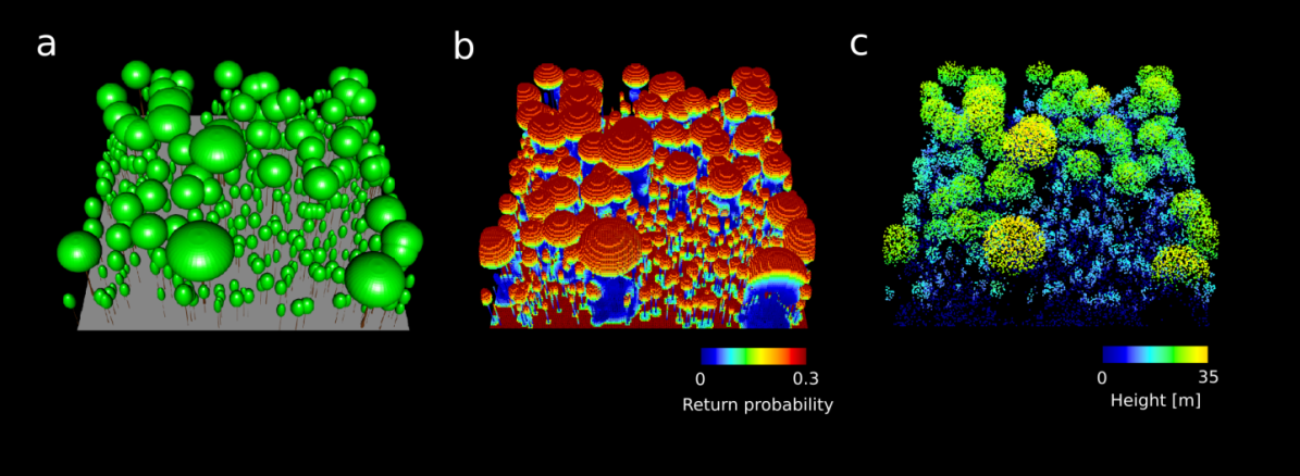
Forest growth simulations serve as an important tool to explore these questions. With forest models like FORMIND (www.formind.org) large datasets of virtual forest inventories can be generated, which thereafter can be systematically screened for the above mentioned research questions.

We work with different types of remote sensing data (such as opitcal data, LiDAR and Radar) in different projects. Three examples:
- The large Helmholtz project “3D-ABC - Global carbon budget for vegetation and soils belongs” belongs to the Helmholtz Foundation Model Initiative (start June 2024, four Helmholtz Centres). It aims to derive novel maps for forest biomass, soil carbon and forest productivity using advanced AI techniques by combining different types of remote sensing measurements (e.g. Tandem-X, Sentinel 1 and 2, GEDI, airborne Lidar).Especially the project aims to integrate and use forest structure parameters derived from radar remote sensing techniques (Tandem-X).

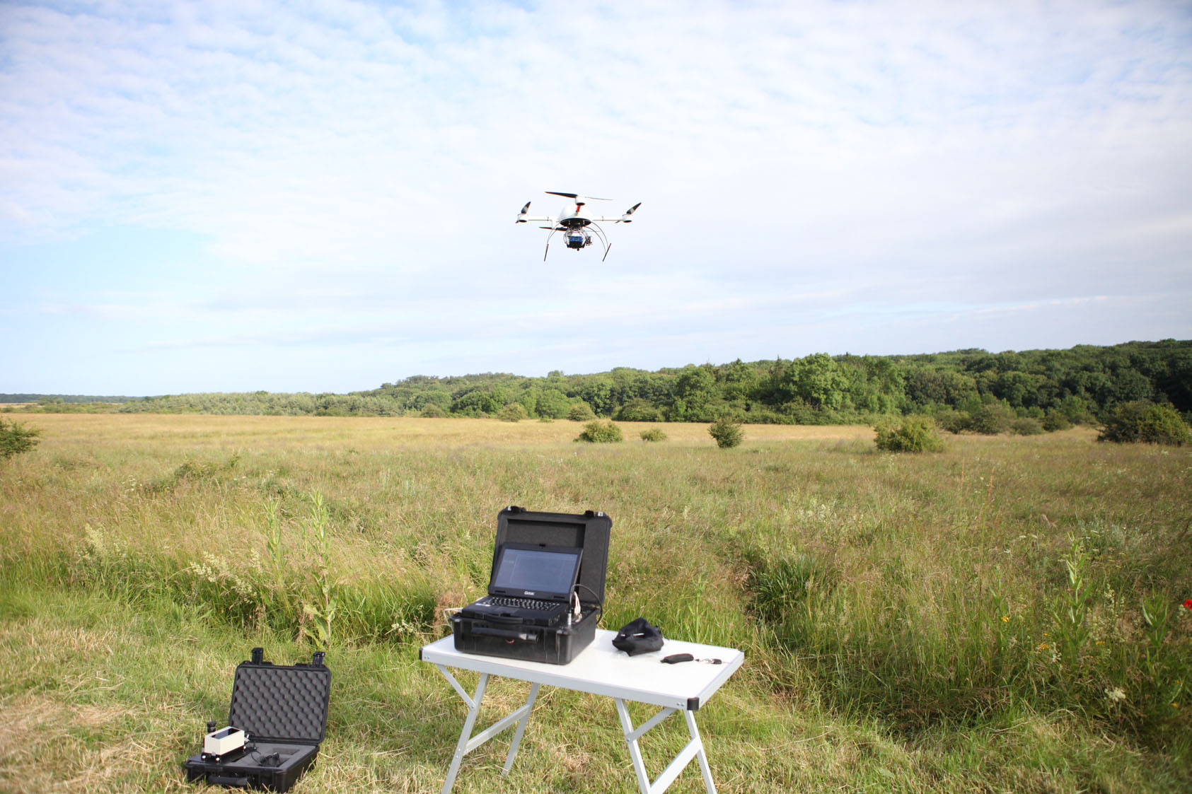
Scanning grasslands and forests with an unmanned aerial vehicle.
- Another project investigates the applicability of unmanned aerial vehicles in the field of ecology. The unmanned aerial vehicle of the OESA department is a quadcopter. This drone has four different sensors: a 24-megapixel RGB camera, a multispectral and a thermal camera, as well as a LiDAR that can be used for 3D-laserscanning of vegetation or other objects. With these sensors, the drone can be used for e.g. acquiring high-resolution images of forests, measuring tree heights based on LiDAR or extracting the NDVI index for the forest canopy.

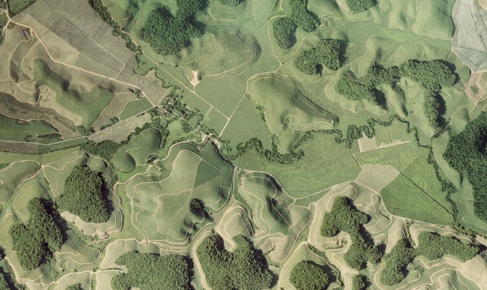
We also use satellite images to analyze forest fragmentation for whole continents (at high spatial resolution, e.g. for the tropics). Because of deforestation in the Amazonl, significantly more carbon has been lost than was previously assumed. To estimate additional carbon emissions at the forest edges, we developed a new approach that integrates results from remote sensing, ecology and forest modelling. The effect of degradation has been underestimated in fragmented forest areas, since it was not possible before to calculate the loss of biomass at forest edges and the higher emission of carbon dioxide.
Selected Publications
- Bauer, L., Huth, A., Bogdanowski, A., Müller, M., Fischer, R. (2024):
Edge effects in Amazon forests: Integrating remote sensing and modelling to assess changes in biomass and productivity
Remote Sens. 16 (3), art. 501 10.3390/rs16030501 - Dechant, B., Kattge, J., Pavlick, R., Schneider, F.D., Sabatini, F.M., Moreno-Martínez, Á., Butler, E.E., van Bodegom, P.M., Vallicrosa, H., Kattenborn, T., Boonman, C.C.F., Madani, N., Wright, I.J., Dong, N., Feilhauer, H., Peñuelas, J., Sardans, J., Aguirre-Gutiérrez, J., Reich, P.B., Leitão, P.J., Cavender-Bares, J., Myers-Smith, I.H., Durán, S.M., Croft, H., Prentice, I.C., Huth, A., Rebel, K., Zaehle, S., Šímová, I., Díaz, S., Reichstein, M., Schiller, C., Bruelheide, H., Mahecha, M., Wirth, C., Malhi, Y., Townsend, P.A. (2024):
Intercomparison of global foliar trait maps reveals fundamental differences and limitations of upscaling approaches
Remote Sens. Environ. 311 , art. 114276 10.1016/j.rse.2024.114276 - Henniger, H., Bohn, F.J., Schmidt, K., Huth, A. (2023):
A new approach combining a multilayer radiative transfer model with an individual based forest model: Application to boreal forests in Finland
Remote Sens. 15 (12), art. 3078 10.3390/rs15123078 - Henniger, H., Huth, A., Bohn, F. (2023):
A new approach to derive productivity of tropical forests using radar remote sensing measurements
R. Soc. Open Sci. 10 (11), art. 231186 10.1098/rsos.231186 - Henniger, H., Huth, A., Frank, K., Bohn, F.J. (2023):
Creating virtual forests around the globe and analysing their state space
Ecol. Model. 483 , art. 110404 10.1016/j.ecolmodel.2023.110404 - Duncanson, L., Kellner, J.R., Armston, J., Dubayah, R., Minor, D.M., Hancock, S., Healey, S.P., Patterson, P.L., Saarela, S., Marselis, S., Silva, C.E., Bruening, J., Goetz, S.J., Tang, H., Hofton, M., Blair, B., Luthcke, S., Fatoyinbo, L., Abernethy, K., Alonso, A., Andersen, H.-E., Aplin, P., Baker, T.R., Barbier, N., Bastin, J.F., Biber, P., Boeckx, P., Bogaert, J., Boschetti, L., Brehm Boucher, P., Boyd, D.S., Burslem, D.F.R.P., Calvo-Rodriguez, S., Chave, J., Chazdon, R.L., Clark, D.B., Clark, D.A., Cohen, W.B., Coomes, D.A., Corona, P., Cushman, K.C., Cutler, M.E.J., Dalling, J.W., Dalponte, M., Dash, J., de-Miguel, S., Deng, S., Woods Ellis, P., Erasmus, B., Fekety, P.A., Fernandez-Landa, A., Ferraz, A., Fischer, R., Fisher, A.G., García-Abril, A., Gobakken, T., Hacker, J.M., Heurich, M., Hill, R.A., Hopkinson, C., Huang, H., Hubbell, S.P., Hudak, A.T., Huth, A., Imbach, B., Jeffery, K.J., Katoh, M., Kearsley, E., Kenfack, D., Kljun, N., Knapp, N., Král, K., Krůček, M., Labrière, N., Lewis, S.L., Longo, M., Lucas, R.M., Main, R., Manzanera, J.A., Vásquez Martínez, R., Mathieu, R., Memiaghe, H., Meyer, V., Monteagudo Mendoza, A., Monerris, A., Montesano, P., Morsdorf, F., Næsset, E., Naidoo, L., Nilus, R., O’Brien, M., Orwig, D.A., Papathanassiou, K., Parker, G., Philipson, C., Phillips, O.L., Pisek, J., Poulsen, J.R., Pretzsch, H., Rüdiger, C., Saatchi, S., Sanchez-Azofeifa, A., Sanchez-Lopez, N., Scholes, R., Silva, C.A., Simard, M., Skidmore, A., Stereńczak, K., Tanase, M., Torresan, C., Valbuena, R., Verbeeck, H., Vrska, T., Wessels, K., White, J.C., White, L.J.T., Zahabu, E., Zgraggen, C. (2022):
Aboveground biomass density models for NASA’s Global Ecosystem Dynamics Investigation (GEDI) lidar mission
Remote Sens. Environ. 270 , art. 112845 10.1016/j.rse.2021.112845 - Getzin, S., Löns, C., Yizhaq, H., Erickson, T.E., Muñoz-Rojas, M., Huth, A., Wiegand, K. (2022):
High-resolution images and drone-based LiDAR reveal striking patterns of vegetation gaps in a wooded spinifex grassland of Western Australia
Landsc. Ecol. 37 (3), 829 - 845 10.1007/s10980-021-01358-9 - Hiltner, U., Huth, A., Fischer, R. (2022):
Importance of the forest state in estimating biomass losses from tropical forests: combining dynamic forest models and remote sensing
Biogeosciences 19 (7), 1891 - 1911 10.5194/bg-19-1891-2022 - Fischer, R., Taubert, F., Müller, M.S., Groeneveld, J., Lehmann, S., Wiegand, T., Huth, A. (2021):
Accelerated forest fragmentation leads to critical increase in tropical forest edge area
Sci. Adv. 7 (37), eabg7012 10.1126/sciadv.abg7012 - Rödig, E., Knapp, N., Fischer, R., Bohn, F.J., Dubayah, R., Tang, H., Huth, A. (2019):
From small-scale forest structure to Amazon-wide carbon estimates
Nat. Commun. 10 , art. 5088 10.1038/s41467-019-13063-y - Taubert, F., Fischer, R., Groeneveld, J., Lehmann, S., Müller, M.S., Rödig, E., Wiegand, T., Huth, A. (2018):
Global patterns of tropical forest fragmentation
Nature 554 (7693), 519 - 522 10.1038/nature25508 - Drusch, M., Moreno, J., Del Bello, U., Franco, R., Goulas, Y., Huth, A., Kraft, S., Middleton, E.M., Miglietta, F., Mohammed, G., Nedbal, L., Rascher, U., Schüttemeyer, D., Verhoef, W. (2017):
The FLuorescence EXplorer mission concept—ESA’s Earth Explorer 8
IEEE Trans. Geosci. Remote Sensing 55 (3), 1273 - 1284 10.1109/TGRS.2016.2621820 - Shugart, H.H., Asner, G.P., Fischer, R., Huth, A., Knapp, N., Le Toan, T., Shuman, J.K. (2015):
Computer and remote-sensing infrastructure to enhance large-scale testing of individual-based forest models
Front. Ecol. Environ. 13 (9), 503 - 511 10.1890/140327
- Köhler, P., Huth, A., (2010):
Towards ground-truthing of spaceborne estimates of above-ground life biomass and leaf area index in tropical rain forests
Biogeosciences 7 (8), 2531 - 2543
Volltext (PDF) - Pütz, S., Groeneveld, J., Henle, K., Knogge, C., Martensen, A.C., Metz, M., Metzger, J.P., Ribeiro, M.C., Dantas de Paula, M., Huth, A., (2014):
Long-term carbon loss in fragmented Neotropical forests
Nat. Commun. 5 , art. 5037
Volltext (PDF) - Shugart, H.H., Asner, G.P., Fischer, R., Huth, A., Knapp, N., Le Toan, T., Shuman, J.K., (2015):
Computer and remote-sensing infrastructure to enhance large-scale testing of individual-based forest models
Front. Ecol. Environ. 13 (9), 503 - 511
Volltext (PDF)
