INCIDENT

Project title: Verwendung von Kanalnetzcharakteristiken zur Ableitung von optimierten punktbasierten Monitoringsystemen - INCIDENT
(Project title – English translation: Utilising sewer network characteristics for the identification of optimised point-based monitoring systems - INCIDENT)
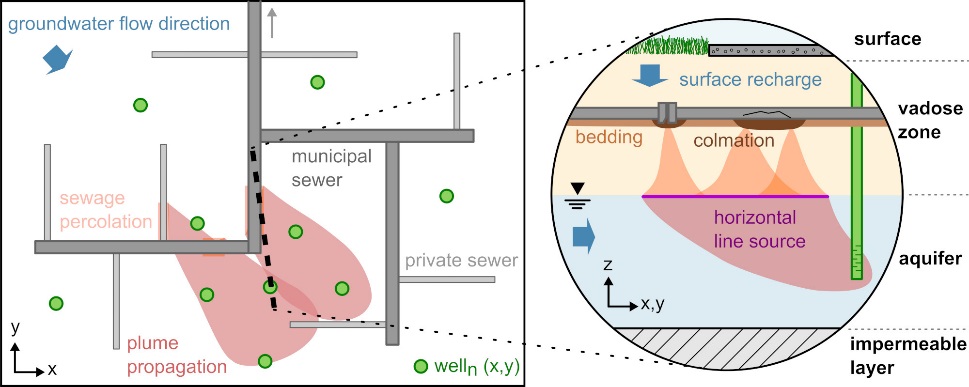
Short project description:The protection of surface and groundwater bodies against potential impacts by various influencing components has become increasingly challenging due to emerging contaminants such as xenobiotics. The effects of these substances on the environment and human life are still not quantifiable and are therefore of focus in current scientific research. A strong potential for safety hazards is provided by sewer leakage. Due to the high span width of sewer age and the associated various sewer failure types, the spatiotemporally highly variable exfiltration of contaminants of various species may provide long-term impact on our ecosystems. Sewage exfiltration and the spatiotemporal distribution of the resulting contaminants within the vadose and saturated zone depend on underground properties as well as properties and the geometrical layout of sewer network systems. Due to the generally vertical flow direction in the unsaturated zone, we hypothesise that sewage contaminant plumes from multiple, small-scale sewer leakages reach the aquifer surface as one- dimensional horizontal line sources of groundwater contamination. It is practically unfeasible to identify or quantify every single leak due to several overlapping processes and external impacts with different spatial and temporal scales. However, we suppose that the field-scale identification of such line sources and their subsequently emerging groundwater plumes via groundwater monitoring will be sufficient for estimating regions of hazardous potential. Often, the monitoring system of urban groundwater resources is restricted from financial constraints and land use of urban environments. Therefore, it must be evaluated, which amount and spatial distribution of groundwater observation points are required for successfully detecting sewer- borne contamination sources.
We hypothesise that, among other system characteristics such as the vadose zone, sewer network geometry has a fundamental influence on contaminant source distribution. Therefore, it will be possible to identify and localise sewer-borne contaminant plumes from groundwater monitoring by acknowledging known sewer network properties and basic site information. Moreover, we will be able to use the characteristics of the spatial distribution of line sources (here: sewer networks) to propose new or optimise existing point-based monitoring networks (here: groundwater sampling). The overall objective of this proposal is to quantify the prediction capability with which a given groundwater monitoring system can locate sewer pipe segments as sources of sub-surface contamination utilising Monte-Carlo modelling approaches. This will avail to deduct optimised groundwater monitoring concepts from a given sewer network layout with a desired accuracy and defined acceptable uncertainty by means of multi- objective optimisation.
Project duration: 01/19 – 12/21
Funding organisation: DFG

Project partners:
- Technische Universität Dresden
- Swiss Federal Institute for Environmental Science and Technology – EAWAG, Switzerland – associated partner
- Commonwealth Scientific and Industrial Research Organisation, Australia – associated partner
- Lyles School of Civil Engineering, Purdue University, USA – associated partner
The research for this project is being conducted in close cooperation with the Chair of Groundwater Management and the Chair of Urban Water Management at the Technische Universität Dresden.
At the UFZ, research for this project is also being conducted at the Department Monitoring and Exploration Technologies.
At the Department of Environmental Informatics, research for this project is being conducted at the workgroup Complex Groundwater Systems.
Project website: https://tu-dresden.de/bu/umwelt/hydro/igw/das-institut/mitarbeiter/marc-walther#section-4
This research was also part of the OpenGeoSys initiative (http://www.opengeosys.org/).
