CoKliP – Cockpit Climate Mission and Planning Acceleration
UFZ Team
Department of Urban and Environmental Sociology
Department of Monitoring and Exploration Technologies / Research Data Management
Partner
City of Leipzig
- Special Section Digital City (project coordination)
- Department Urban Planning
- Department Urban Greening and Watercourses
- Department Environmental Protection
- Department Geoinformation and Land Management
Leibniz Institute for Tropospheric Research – TROPOS
Institute for Applied Informatics – InfAI
Duration
January 2026 – December 2027
Funding
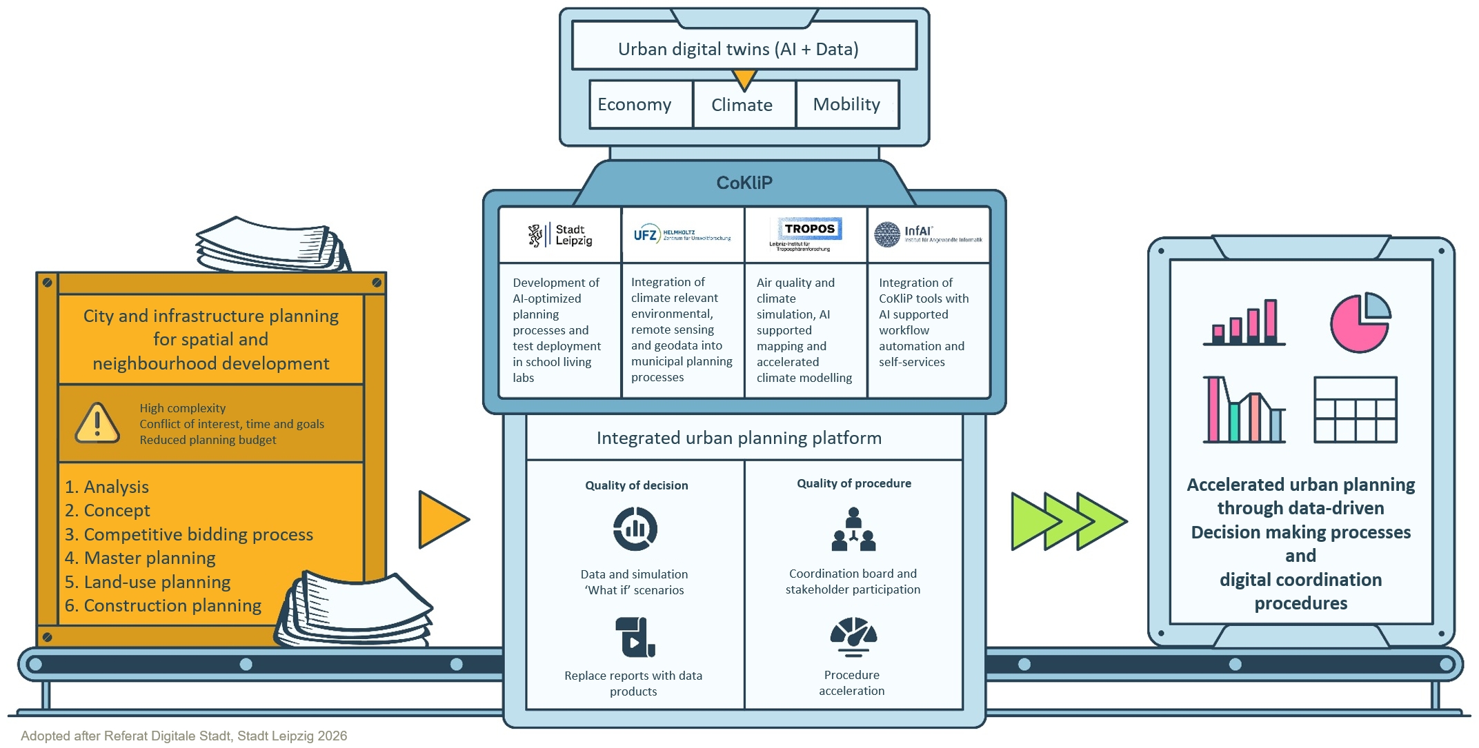
The German run CoKliP project—Cockpit Climate Mission and Planning Acceleration—is developing digital and AI-powered tools that enable municipalities to accelerate their planning processes.
As an extension of the Leipzig Urban Digital Twin (L-UDZ) , CoKliP combines climate-related data with other environmentally relevant data to enable faster consideration of evolving environmental protection and climate adaptation requirements at the citywide level, the neighbourhood level, and for individual projects. These requirements pertain to land use, building façades, and blue-green infrastructure, and are integrated into typical planning and decision-making processes (e.g., heat-stressed or water-sensitive urban development). The complex requirements of the climate mission become easier to assess when measures, conflicts, and interactions are visualised in a clear and comprehensible manner. In doing so, CoKliP is also intended to reduce the time and resources required.
The novel synergies thus generated are utilised in such a way that automated, faster decision-making processes can be carried out without having to rely on lengthy and costly expert reports. At the same time, the visualisation and simulation capabilities of Digital Twin technologies can be used to raise awareness of climatic pressures and extreme events (shocks) amongst public administration, policymakers and the general public.
The work package led by the UFZ, ‘AI-supported mapping & modelling; municipal data management’, develops scenarios that cover the two extremes of ‘intensified land sealing due to construction activity’ and ‘extensive land unsealing, including urban green spaces’. In the test area, these are used to model the impacts of such land-use changes on ecosystem services and, consequently, on the environmental health of the local population. This information is combined with scenarios for car-based traffic management (AIAMO project) and with the meteorological scenarios generated by Tropos (air temperature and humidity, nitrogen oxides, particulate matter [PM]). This is where AI comes into play, evaluating the multi-scenario analysis in such a way that the complex influencing factors can be transparently understood, optimally utilised and managed. The resulting tools designed to improve quality of life (e.g. unsealing; geothermal energy) are being increasingly and effectively integrated with one another.