Case Study Central Germany
Short description
The region Central Germany comprises the federal states of Sachsen, Sachsen-Anhalt and Thüringen and covers 55,000 km². The population of currently 10 Mio people is shrinking since the 1990ies, except in the two largest cities Dresden and Leipzig.
Spatial datasets available for Central Germany
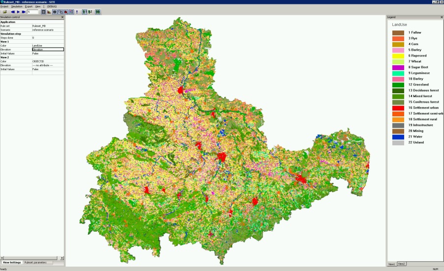
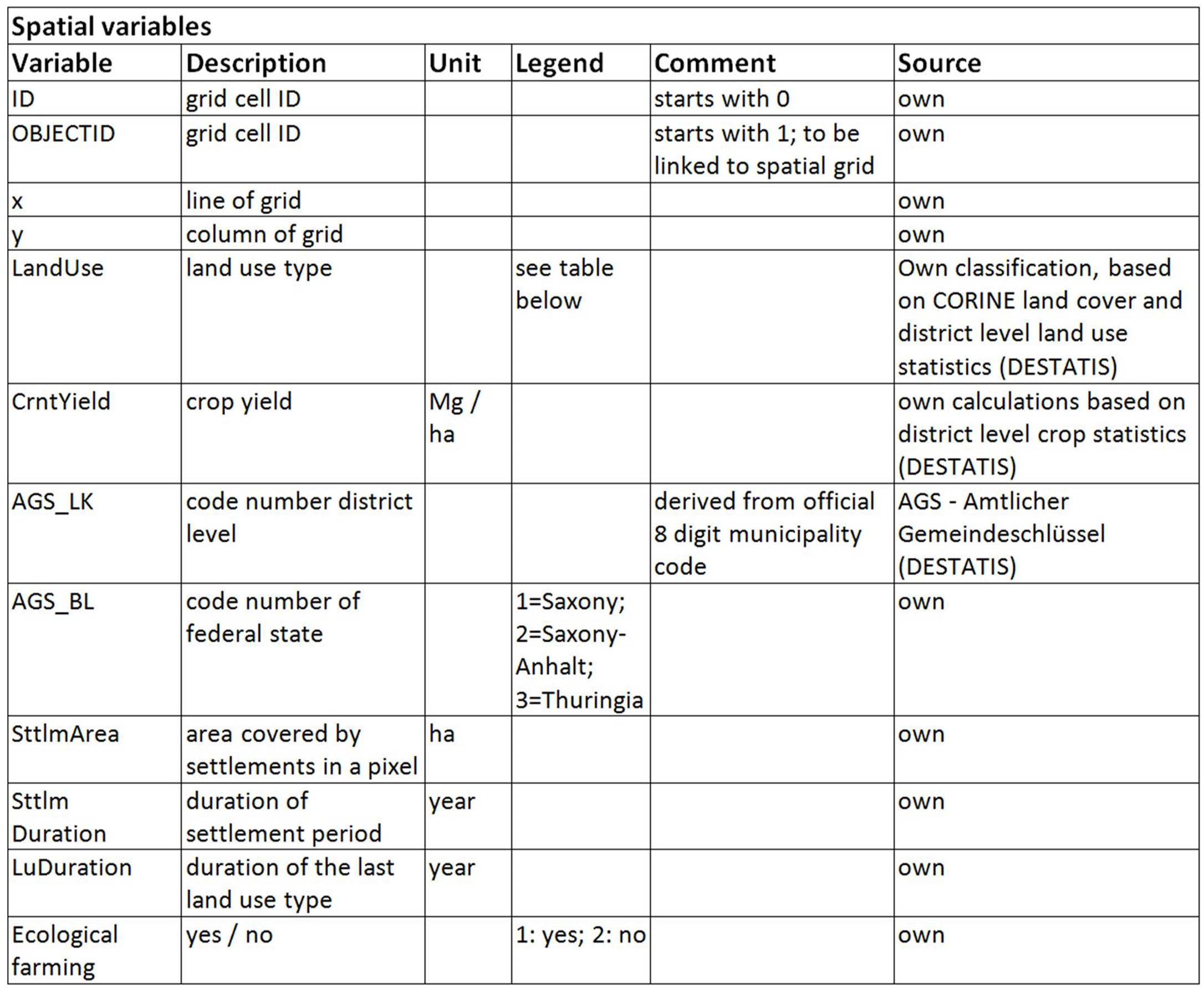
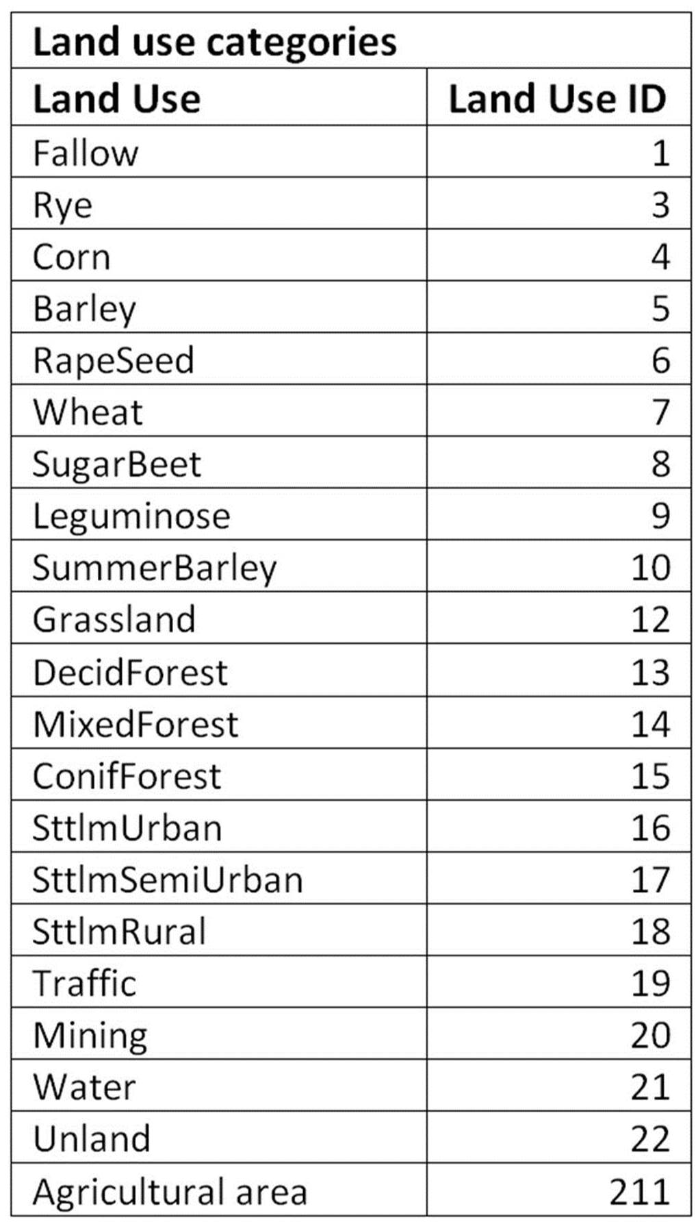
Spatial datasets are all based on the 500m grid for Central Germany as an ARCGIS shapefile in which all pixels have a unique ID. This ID can be used to link the spatial data (=grid) to the scenario tables, which are provided in the data files either in cvs or in EXCEL format. Please also read the read_me files provided with the data files for more details on the spatial scenario datasets. Land use and population scenarios for Central Germany (55,000 km²) have been calculated with the SITE model in annual time steps (2006 – 2050) on a 500 m grid. Land use maps are made available for the years 2006 – 2020 – 2035 – 2050, comprising 22 land use classes (3 urban, 3 forest, 10 agriculture, 6 others such as water, infrastructure).
The four Scenarios are described in Priess and Hauck (2014), a detailed brochure is available in German at:
here
Spatial data Central Germany:
here
Metadata to spatial data:
here
Population scenarios (non-spatial):
here
Population scenarios Spatial Data:
here
Land use scenario data:
here
Data characteristics:
Central Germany Scenario-related Refs:
Priess J.A., Christian Hoyer, Greta Jäckel, Eva Lang, Sebastian Pomm, Christian Schweitzer 2018. Selected trade-offs and risks associated with land use transitions in Central Germany. In: M. Schröter, A. Bonn, S. Klotz, R. Seppelt, C. Baessler (eds.) Atlas of Ecosystem Services: Drivers, Risks, and Societal Responses. Springer DOI: 10.1007/978-3-319-96229-0_21
Priess, J. A. and J. Hauck. 2014. Integrative Scenario Development. Ecology and Society 19 (1): 12. [online] URL
Hauck, J. and Priess J.A. (2013). „The most likely future isn’t“: Landnutzungsszenarien für Mitteldeutschland. Raumforschung und Raumordnung.
DOI: 10.1007/s13147-013-0248-5
The SITE modeling framework has been used for the spatial simulations. SITE is a model simulating land use dynamics and various environmental impacts, adaptable to different research questions and case study regions. SITE is mostly applied at regional scale (1000 km² - 100.000 km²).
SITE-related Refs:
Central Germany Data were used in:
Meyer M., R. Seppelt, F. Witing, and J. A. Priess (2016) How can we compare environmental and ecosystem service assessments for biomass production systems in different parts of the world? Environmental Research Letters 11. doi:10.1088/1748-9326/11/3/034005
(Other Central Germany related papers are currently under revision; status: 04/2016)
Priess J. A., C. Schweitzer, O. Batkhishig, T. Koschitzki, D. Wurbs (2014) Impacts of agricultural land-use dynamics on erosion risks and options for land and water management in Northern Mongolia. Environ Earth Sci. DOI 10.1007/s12665-014-3380-9
Priess J. A., C. Schweitzer, F. Wimmer, O. Batkhishig, M. Mimler (2011). The consequences of land-use change and water demands in Central Mongolia. J. Land Use Policy 28/1, 4-10.
Das, S., Priess, J.A., Schweitzer, C. (2012) Modelling regional scale biofuel scenarios – a case study for India. GCB Bioenergy 4 (2), 176 – 192. ( DOI )
Schweitzer C., Priess J.A., Das S. 2011. A generic framework for land-use modelling. Environmental Modelling & Software 26/8, 1052-1055.
Priess J.A., M. Mimler, A.-M. Klein, S. Schwarze, T. Tscharntke, I. Steffan-Dewenter 2007. Linking deforestation scenarios to pollination services and economic returns in coffee agroforestry systems. Ecological Applications 17/2, 407-417.
Any questions welcome:
email
Environmental Services in Saxony
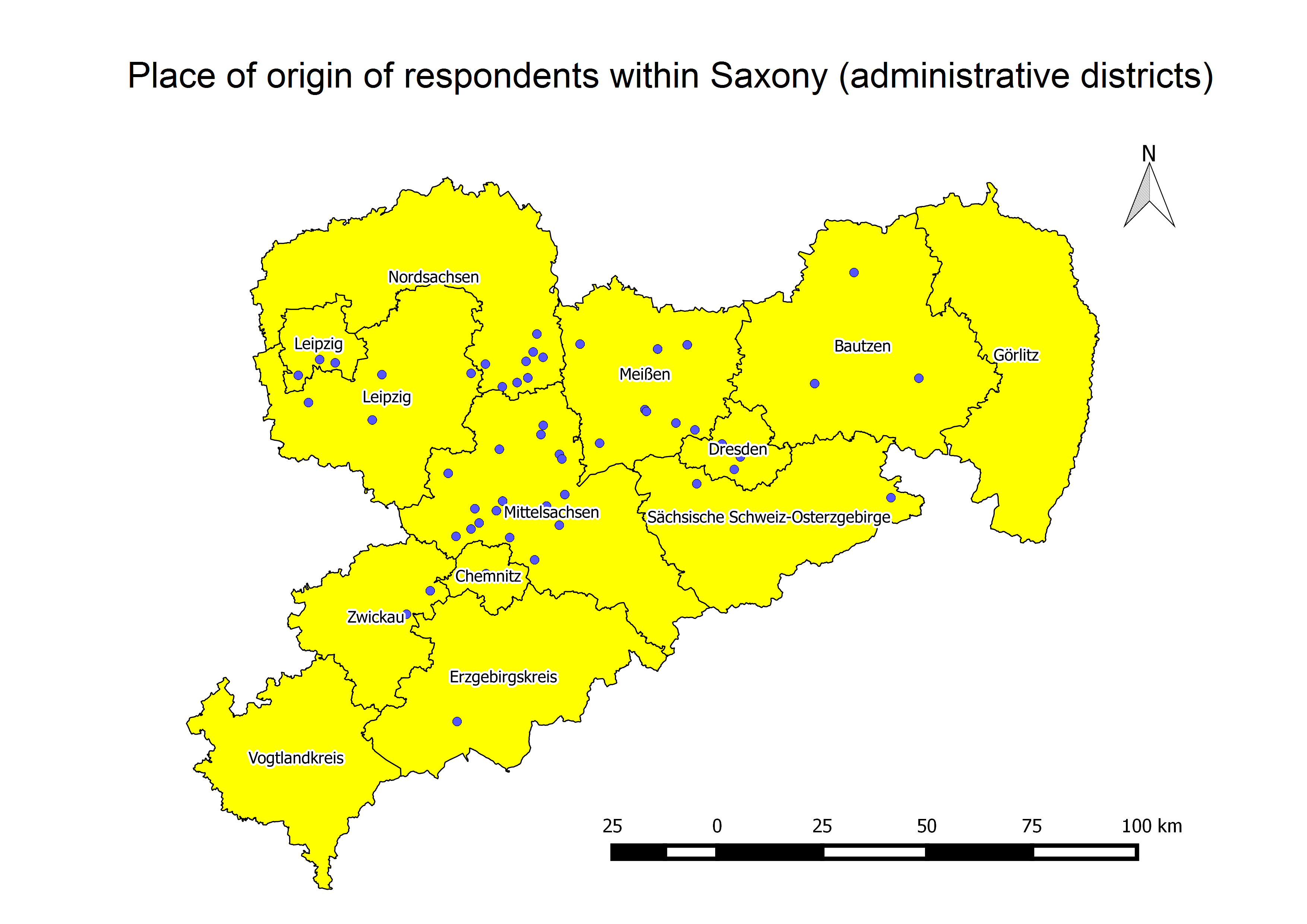
The map shows all administrative districts in Saxony. The blue dots denote the places of origin of the respondents.
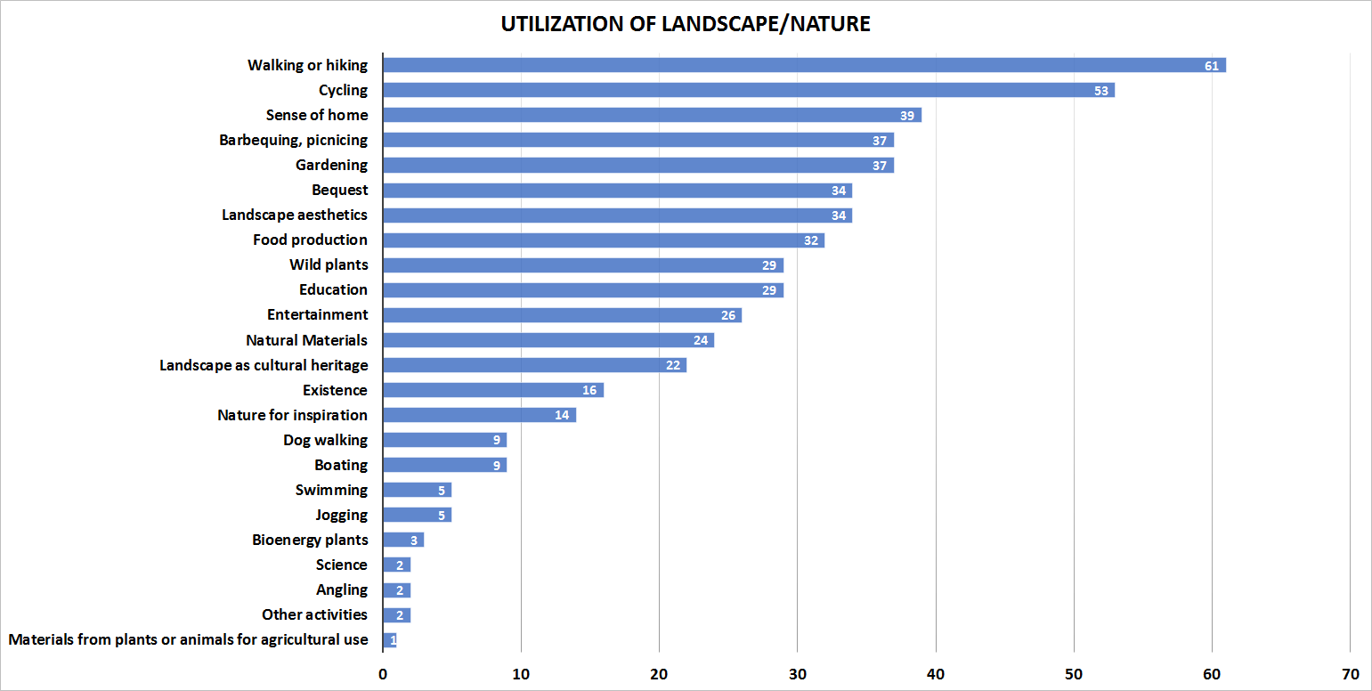
The bar diagram displays the different utilization or the immaterial value of the landscape or nature, respectively. Walking or hiking and cycling are the most important physical activities whereas sense of home is the most important immaterial value.
Further information about the study will be added soon.
Related Projects
Land-Use Scenarios for Central Germany (Link)
Case Study Advisory Board (Link)
SITE - Central Germany (Link)

