Subproject 1
LandTrans Simulator
Team LandGH2O - Groundwater Modelling
The sustainable and sufficient availability of clean groundwater is essential for the existence and diversity of terrestrial and aquatic ecosystems as well as for ensuring industrial, commercial and agricultural value creation and the supply of sufficient drinking water. Simulation of groundwater resources in computer models is based on the realistic geometry and parameterization of reservoir rocks, area-wide calculations of recharge volumes incorporating insitu measurements of groundwater levels and spring discharges. Thus, the amount of water passing the subsurface in a certain time becomes transparent. Knowledge of stored volumes and their change over time as a function of climatic factors and withdrawal rates is an authoritative tool for assessing and developing local to national management strategies for policy and economic decision makers.
For this purpose, the team develops solutions for the generation of subsurface geometries on a supraregional to national scale, optimizes process-based model systems for the simulation of groundwater flows in space and time also by integrating hydraulic and isotope-based monitoring.
Contact: Dr. Christian Siebert, Department Catchment Hydrology
Team LandQuali - Water Quality Modelling

Water quality in surface and groundwater is a critical component in ensuring adequate water resources for human use over the long term and an important boundary condition for the health and function of aquatic ecosystems. In this regard, excess nutrients from human sources such as agriculture and wastewater, in particular, pose a complex and persistent problem. Simulation of water quality in watersheds using computer models is based on linking biogeochemical and ecological processes with hydrological simulations, i.e., calculating water fluxes in the landscape. This involves calculating nutrient fluxes on multiple flow paths across the landscape and making the results available to other scientists and policy makers for deriving management strategies.The team develops and implements routines for calculating and parameterizing reactive nutrient transport on the regional to continental scale within the LandTrans Simulator.Team LandVeg - Vegetation Modelling
As ecosystems, forests and grasslands play a key role in Germany's future, providing a wide range of ecosystem services: including biodiversity, biomass, timber, climate regulation and local recreation. However, these important functions are increasingly affected by climate change and land use changes. The expected intensification of the climate crisis is pushing existing management of these ecosystems to their limits and will require extensive adaptation. This makes the development of innovative modeling approaches imperative.
The dynamics of forest and grassland ecosystems are simulated using mechanistic model components that calculate the growth of individual trees and plants based on a carbon balance - under the influence of weather data, soil resources and management information. Model-based estimates of ecosystem productivity, carbon storage, and biodiversity under climate change scenarios, extreme weather events, and management changes are made available to other scientists or policy makers for deriving management strategies and recommendations for action. The team develops the dynamic vegetation model components for the simulation of forests and grasslands within the LandTrans Simulator and develops concepts and collects relevant data for the simulation of both ecosystems on the regional and Germany-wide scale.
Contact: Dr. Franziska Taubert, Department Ecological Modelling

Team LandAgri - Crops and Management
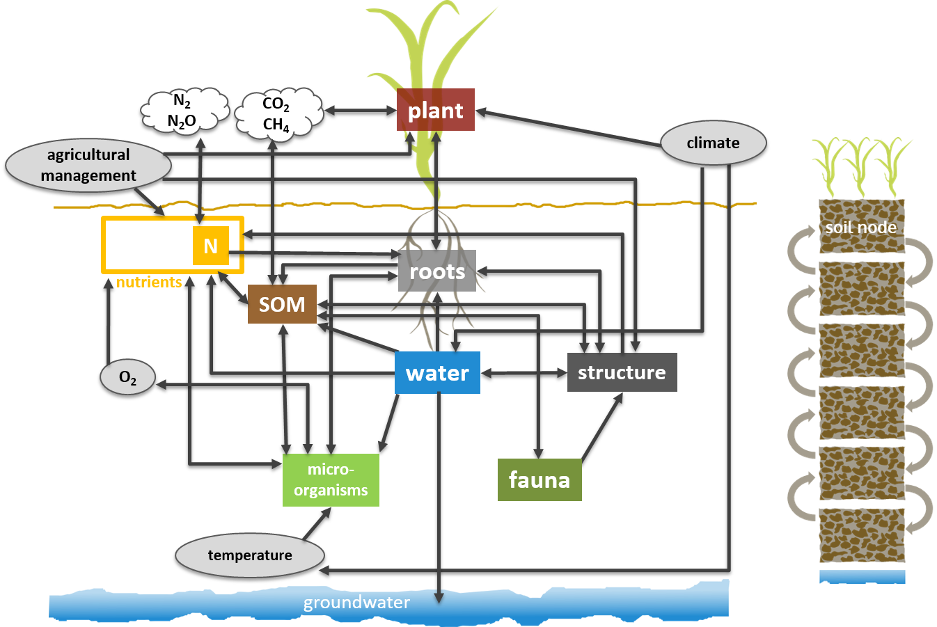
Agriculturally used soils are on the one hand the basis for feeding a growing world population, on the other hand they fulfill important functions in terrestrial ecosystems for the water and material balance as well as for biodiversity. Computer models can be used to represent soil processes in such a way that the effects of various soil management measures and of a changing climate on the various soil functions can be estimated. Water fluxes, carbon turnover, and nutrient cycling for different sites and soil properties are calculated along with plant growth, and the resulting soil functions are made available to other scientists or policy makers for deriving management strategies. As part of the LandTrans Simulator, the team is developing the necessary soil process model and devising methods to determine the high-spatial-resolution distribution of soil properties at the scale of Germany using remote sensing and other available geospatial data.
Team LandTech - Data and Computing
At the UFZ, models are developed to simulate the terrestrial water cycle (water quantity and quality), the carbon cycle in forests and grasslands, and biogeochemical fluxes on croplands. The team is developing the FINAM coupling software to efficiently couple these models together to enable the simulation of multifunctional landscapes. FINAM explicitly allows two-way coupling between two models (see figure). The LandTech team also provides extensive documentation on FINAM (
Webpage
, under development) so that FINAM can be easily applied and further developed by UFZ scientists. Contact: Dr. Stephan Thober, Department Computational Hydrosystems
