Groundwater Systems
The working group is led by Dr. Christian Siebert and the group's activities focus on the quantitative and qualitative assessment of groundwater resources, the interactions of ground- and surface water bodies and the impact of climate and socio-economic changes on the available water resources.
The aim of our group is to combine traditional and innovative monitoring technologies to provide the essential data sets for multiscale modelling of the actual state and possible development of water resources in Germany and beyond in other European and also in semi-arid regions.
We believe in the success of multidisciplinarity and are open to respective combined research and modeling tools.
Hot Artesian Well in the Yarmouk Gorge, Jordan. (image: C. Siebert)
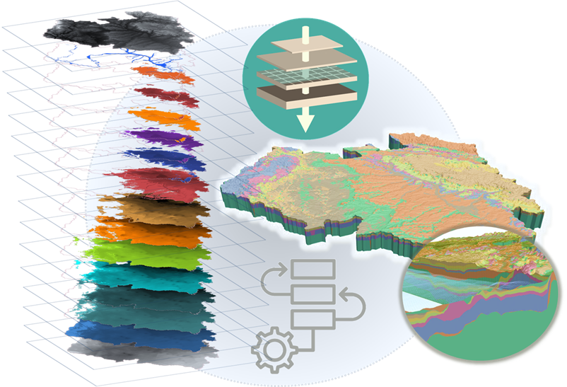
Development of a large-scale groundwater resources model for Germany
In the light of global and climate changes, a profound knowledge about existing groundwater storages and about the future availability of ground- and surface water resources becomes more and more important for a sustainable development of a region. The quantitative and qualitative impact of changing conditions (e.g. increased abstraction) must become predictable on a local to regional scale. Such holistic questions can be tackled by effectively parameterized, realistic process models that encompass all components of the terrestrial hydrologic cycle and are capable of predicting systems across catchment boundaries.
Therefore, a regional numerical groundwater model will be set up on the base of a close-to-reality 3D hydrogeological structure model, comprising regionally aquiferous strata and aquicludes, which are relevant for current and future urban, agricultural and industrial water usages. The hydrogeological workflow to produce such regional datasets was developed within the workgroup and will be applied to produce them for the large river basins of Danube, Rhein, Weser/Ems, Elbe and the NE German rvers (Oder, Peene, etc), discharging into the Baltic Sea. They will eventually be combined to a national model. First sucessful model was prepared for the German Danube Catchment.
These activities are part of a larger project team of hydrogeologists, hydrologists and software engineers, which aims to come up with a numericl groundwater resources model, forced by the groundwater recharge produced by a hydrological model which in turn is driven by climate data and projections into the future.
The groundwater model is part of the platform projects WatQ2E and Tim4Water.

Groundwater-Surface Water Interactions (GSI) on a large scale (Elbe River)
Groundwater inflow can have significant effects on the water quality of riverine systems. It is a potential source of contaminants and represents a major diffuse source of nutrients (N, P, DOC). Diffuse groundwater born nutrients significantly enhance the risk of eutrophication with severe consequences for water quality and ecosystem health in rivers and estuaries. Thus, knowledge of where, when and how much groundwater discharges as well as the respective dynamics and composition of such mainly diffuse inputs are of high importance to assess the GSI.
Beyond the impact on rivers and lakes, a profound allocation and characterization of GSI provides a great way to understand the spatially and temporally variable release from or uptake of water by riparian aquifers. That in turn tells a lot about the groundwater system and the migration of water therein.
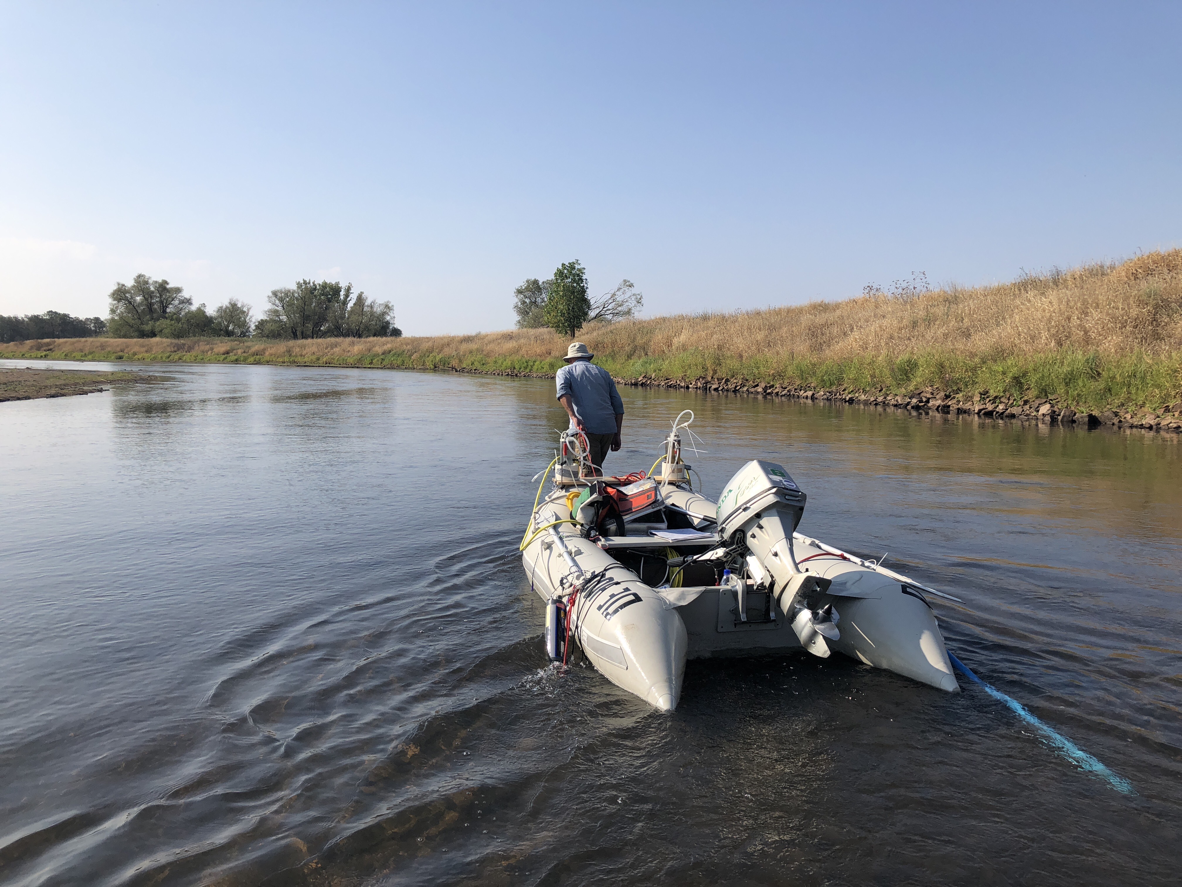
In August 2018, the Elbe River suffered from extremely low flow conditions, a result of the continuous drought conditions since February of that year. The exceptional low discharge of the Elbe suggested a survey to understand the contribution of groundwater to the river between the Czech border at Schöna and Havelberg, 425 km downstream. The aim was to outline hotspots and amounts of GSI and to learn about the aquifers. Therefore, samples for dissolved inorganic and organic substances as well as stable and radio-isotopes have been collected in 2018 within the river at every 2 km and later in 2020 in the major contributing streams, from groundwater springs and wells as well as from effluents of waste water treatment plants, respectively.
The exploration of data sets is part of the PhD thesis of Julia Zill.

Long-term impact of 2018-2020 drought period in the Harz Mountains
The drought conditions between 2018 and 2020 terminated the coverage of the Harz Mountains with dense monoculture of spruces. An invasion of bark beetles led to an almost complete deforastatioon of the Harz during the last years. As a consequence, the dynamic of surface hydrology, erosion and most probably the amount and composition of groundwater recharge are affected by that fundamental land cover change.
As part of a larger UFZ team, we aim to systematiccally monitor and investigate the behavior of groundwater recharge and of surface runoff generation as a consequence of precipitation. That study will particularly address the impact in areas, which will be either (i) reforestated by monocultures again, (ii) reforestated by mixed forest or (iii) released for natural succession. Instrumentation comprises soil hydrological stations as well as measuring weirs, geoelectrical sounding and profiling, etc. Therefore, a collaboration with the City of Wernigerode, the National Park Association Hochharz, the State Office for Flood Protection and Water Management (LHW) as well as the forestry authority of Saxony-Anhalt is or will be soon established.
For more information either contact Christian Siebert or Stefan Geyer
Impression from Brocken Mountain and the City of Schierke (Mrz. 2022). (image: C. Siebert)
Helmholtz AI Projekt AI-QUIFER
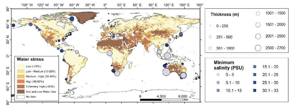
The current stress on global freshwater supplies, particularly in densely populated coastal regions, will be exacerbated significantly by ongoing climate change, associated seawater rise and population increase (Figure 1). A future sustainable water supply for coastal regions will depend on our understanding of ground- and seawater interaction in amphibious coastal aquifer systems.
In many coastal regions the fresh-/saltwater interface (FSI) is moving landward, signifying a potential threat to water security through saltwater intrusion. However, in some regions of the world, the FSI in the subsurface may also be located 10s of kilometres seaward, on the shelf, indicating the presence of offshore freshened groundwater (OFG) and signifying a reduced threat to coastal fresh water supplies.
Within this collaborative high risk AI project between GEOMAR, Helmholtz Centre for Marine Research Kiel and UFZ Helmholtz Centre for Environmental Research, we aim to use globally available geospatial data on surface features (e.g. Digital Elevation Model, Land Surface Models, shelf bathymetry and the GRACE datasets), in conjunction with climatic data and hydrogeological modelling, to predict the globally the largely unknown location of the FSI in the subsurface. We expect to provide a tool that allows us to produce global probability maps of the location of the coastal fresh/saline water interface (a proxy for OFG), that can be adjusted to future climate scenarios.
The gain from developing an inexpensive, computationally efficient method to predict the existence and extent of offshore groundwater is undeniably a major advancement for all stakeholders on sustainable coastal water management. It will significantly impact how sampling/drilling strategies are devised in future reconnaissance studies.
For more information about the project contact Christian Siebert and for OFG see also: here

symbols denote sites where OFG thickness could not be determined (Micallef et al., Review of Geophysics, 2022).
