Press Release, 12. December 2016
Remote sensing is becoming increasingly important in biodiversity research
New satellites open up further opportunities
To measure biodiversity, researchers have been using various methods of remote sensing for about 30 years in addition to traditional field studies. Under the auspices of UFZ scientists, an international team of researchers present current opportunities, developments and prospects of remote sensing in the journal Ecological Indicators and highlight its enormous potential in assisting future biodiversity research.

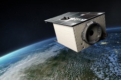
Photo: DLR CC-BY3.0
The consequences of climate change are evidenced, inter alia, by changes in biodiversity. A key task of biodiversity research is to record the current situation, study processes within ecosystems and identify possible changes as well as disturbances. "To do this we need reliable data across large areas and close periods of time," says UFZ Landscape Ecologist PD Dr. Angela Lausch. "Various remote sensing methods already meet these requirements in a remarkable way." By using satellite images, the distribution of a plant species to be studied can, for example, be determined based on its growth habit, leaf shape, leaf geometry, phenology or flower colour - over large areas and over time. In addition, satellites are equipped with spectral sensors which help to distinguish and record plant species or plant communities based on their specific biochemical properties (chlorophyll, cellulose, leaf water content or protein content, etc.).
Depending on the question being studied, the methods of remote sensing generally vary in their capability to measure biological diversity. When choosing the method, it must always be considered whether the remote sensing sensor can actually measure the selected key parameters - that is, whether the spectral, spatial or temporal resolution is adequate in answering the question and what conclusions can be derived from this for biodiversity research. "Looking ahead, it is therefore essential that biologists, ecologists, geographers and remote sensing specialists cooperate more closely than has previously been the case and become better acquainted with the discourse of others," says UFZ biodiversity researcher Prof. Josef Settele, co-author of the study. The traits of plants, animals, water and soil are what links remote sensing to other disciplines," adds Lausch.
The hyperspectral satellite EnMAP (Environmental Mapping and Analysis Program) is due to be launched in 2018 and will provide image data with very high spectral resolution. Hyperspectral remote sensing could then be used to measure many more biochemical parameters, such as nitrogen, phosphate or the water content in leaf tissue. "EnMAP will significantly improve the identification of species and plant communities via remote sensing. However, the greatest potential offered by hyperspectral remote sensing lies in measuring processes and disturbances within ecosystems over large areas," says Lausch. "The data produced by the EnMAP satellite will be freely available to all users. We, in biodiversity research, should therefore be prepared to recognise and leverage the potential of the new generation of satellites."
However, we will still need field studies, where samples are collected, species and plant communities recorded and ecosystem processes - such as photosynthesis activity or the ability to bind carbon - are identified. Unlike remote sensing, they only represent a local and temporary sample and are also time-consuming, costly and usually tedious to evaluate. However, they provide crucial information that cannot be recorded via remote sensing - such as information on ecological potency, stress behaviour and the adaptability of species and plant communities. In addition, they are indispensable for evaluating and interpreting remote sensing data. "One is not possible without the other," says Lausch. "Biodiversity can only be measured more accurately than before and processes, including their changes and disturbances, mapped on various spatial and temporal scales by combining in-situ studies and remote sensing."
However, in terms of practical implementation, there are still a few stumbling blocks, says Lausch. A typical stumbling block is the fact that worldwide there are still very few uniform standards dedicated to measuring biodiversity data. In addition, the link between field and remote sensing data must be optimised so that it is easier to aggregate large, complex and heterogeneous data volumes and data can be more easily evaluated and transferred to models.
A key step in this direction is the so-called "Essential Biodiversity Variables" (EBV), the development of which has been possible due to the efforts of scientists such as Angela Lausch and many of her co-authors worldwide.
Publication:
Lausch, A., Bannehr, L., Beckmann, M., Boehm, C., Feilhauer, H., Hacker, J.M., Heurich, M., Jung, A., Klenke, R., Neumann, C., Pause, M., Rocchini, D., Schaepman, M.E.; Schmidtlein, S., Schulz, K., Selsam, P., Settele, J., Skidmore, A.K., Cord, A.F., 2016. Linking Earth Observation and taxonomic, structural and functional biodiversity: Local to ecosystem perspectives. Ecological Indicators 70., 317-339., http://dx.doi.org/10.1016/j.ecolind.2016.06.022.
Further links:
UFZ press release "Biodiversity variables could help to prevent species loss", http://www.ufz.de/index.php?en=36336&webc_pm=50/2016
GEO BON, the Group on Earth Observations Biodiversity Observation Network http://www.geobon.org/
iDiv / International GEO BON Office: https://www.idiv.de/research/international_office_geo_bon.html
Further information
PD Dr. Angela Lausch
UFZ-Department Landscape Ecology
angela.lausch@ufz.de
UFZ press office
Susanne Hufe
Phone: +49 341 6025-1630
presse@ufz.de
In the Helmholtz Centre for Environmental Research (UFZ), scientists conduct research into the causes and consequences of far-reaching environmental changes. Their areas of study cover water resources, ecosystems of the future, environmental technologies and biotechnologies, the effects of chemicals in the environment, modelling and social-scientific issues. The UFZ employs more than 1,100 staff at its sites in Leipzig, Halle and Magdeburg. It is funded by the Federal Government, Saxony and Saxony-Anhalt.
www.ufz.deThe Helmholtz Association contributes to solving major challenges facing society, science and the economy with top scientific achievements in six research fields: Energy; Earth and Environment; Health; Key Technologies; Matter; and Aeronautics, Space and Transport. With some 39,000 employees in 19 research centres, the Helmholtz Association is Germany’s largest scientific organisation.
www.helmholtz.de