
Water
Within the water topic we have four main aspects that either concern water directly or investigate phenomena induced by water. These comprise the derivation of groundwater flow paths, the localisation of submarine groundwater discharge, and morphological surface changes (sinkholes) through dissolution of salt-laden sediment in the subsurface.
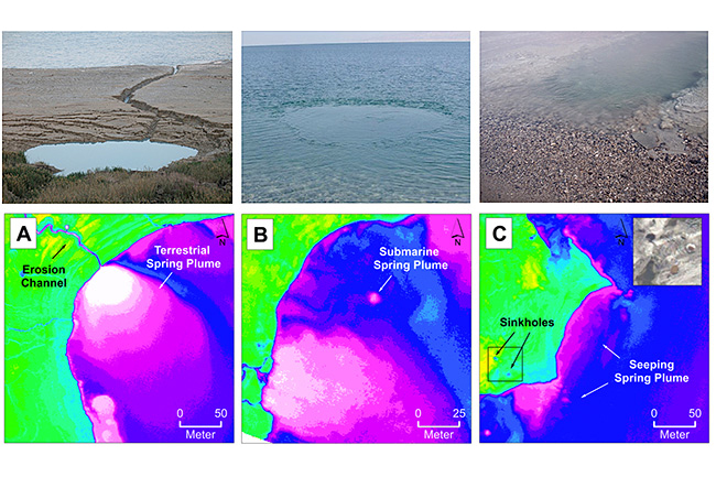
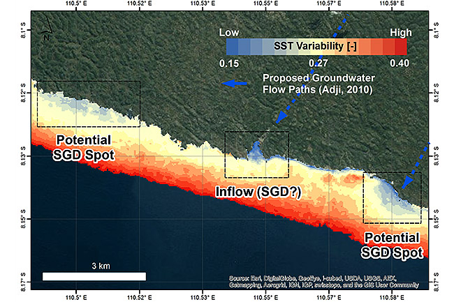
Submarine groundwater discharge (SGD) has gained attention over the last years. While percental discharge contribution and its nutrition loads is estimated to be similar or even above to riverine contribution its exact locations and location-specific quantities remain largely unkwown in large parts of the world.
On the assumption of SGD thermally stabilising a certain sea-surface area at the discharge location over time in contrast to ambient uninfluenced areas we exploit small variabilties of sea-surface temperatures (SST) as indicators. These SST variabilities are derived through applying multi-temporal analyses of satellite-borne thermal data (Landsat ETM+, OLI).
We compensate the coarse spatial resolution associated with many satellite-based approaches by using mono-temporal airborne and multitemporal UAV-based thermal investigation at selected sites. The clear advantage concerns the spatial detail and the user-defined application allowing to detect, characterise and quantify even small scale SGDs.
Thermal SGD indication plus its characterisation are backed by further data such as i) bathymetric data (through an unmanned surface vehicle - USV) that, besides shear depth at high spatial resolution, provide morphological information and hence fault patterns giving insights in preferential groundwater flow-paths, ii) similar morphological/fault analysis (lineament analysis) and likewise vegetation analysis on land providing water abundance and flow-paths, and iii) established hydrochemical in-situ tracer (222Rn, 2H, 18O , Salinity, Temp., REY) for validation purposes.
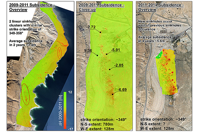
Sinkholes, a phenomena that results from dissolution of dissolvable material in the subsurface through water and a subsequent partly sudden subsidence, endanger infrastructure, agricultural sites and human beings. Unknown remains future sinkhole appearance and hence, the chance to prepare and counteract in advance to the occurence. Through the repeated application of an UAV equipped with a RGB camera, selected areas are monitored at high precision and spatial resolution aiming to understand the temporal 3D-sinkhole development on small scales using a SfM approach.
Satellite Sensors:
Landsat 7/8
ASTER
RapidEye
MODIS
Hyperion
UAV Sensors:
Flir Tau2 640x512 (Thermal Radiometric Camera)
Sony Apha Nex7 (RGB Camera)
Dead Sea - Israel, Palestine, Jordan
Black Sea - Romania, Georgia
Atlantic Ocean - South Africa
Mediterranean Sea - Monaco, Israel
Indian Ocean - Mauritius, Java
SUMAR - Sustainable Management of Water Resources (Quantity and Quality) in the Dead Sea Area (finished)
BS-ERANet – Investigation of Submarine Groundwater Discharge for preventing pollution and eutrophication of the coastal Black Sea (finished)
SPACES – Groundwater / Seawater interaction along the African South Coast and its Effects on Sustainable Coastal and Water Resource Management (until 2017)
DESERVE - The Virtual Institute Dead Sea Research Venue (until 2017)
Schubert, M., Scholten, J., Schmidt, A., Comanducci, J. F., Pham, M. K., Mallast, U., and Knoeller, K.: Submarine Groundwater Discharge at a Single Spot Location: Evaluation of Different Detection Approaches, Water, 6, 584-601, 2014.
Mallast, U., Siebert, C., Wagner, B., Sauter, M., Gloaguen, R., Geyer, S., and Merz, R.: Localisation and temporal variability of groundwater discharge into the Dead Sea using thermal satellite data, Environmental Earth Sciences, 1-17, 10.1007/s12665-013-2371-6, 2013.
Mallast, U., Schwonke, F., Gloaguen, R., Geyer, S., Sauter, M., and Siebert, C.: Airborne Thermal Data Identifies Groundwater Discharge at the North-Western Coast of the Dead Sea, Remote Sensing, 5, 6361, 2013.
Mallast, U., Gloaguen, R., Geyer, S., Rödiger, T., and Siebert, C.: Derivation of groundwater flow-paths based on semi-automatic extraction of lineaments from remote sensing data, Hydrol. Earth Syst. Sci., 15, 2665-2678, 10.5194/hess-15-2665-2011, 2011.
Satellite-based Multi-temporal Thermal Analysis, Airborne (including UAV) Thermal Analysis, Geomorphological and vegetation analysis
Satellite-based Multi-temporal Thermal Analysis
Bathymetric Investigation, Rare-Earth Elements (REY)
Radon (Rn)
Stabile Isotope (18O, 2H)
Geomorphological analysis