Contracting Institution

Partners

Objectives
4DHydro is a response to the Invitation to Tender (ITT) of the European Space Agency with reference number ESA AO/1-11298/22/I-EFin July 2022.
It aims at:
- To perform a thorough assessment of the uncertainty of existing EO and LSM/HM data sets (Tier 1) related to key tECVs.
- To generate improved tECVS datasets at 1 km spatial resolution in the selected study areas (Tier 2).
- To perform targeted science cases to demonstrate the synchronization of EO products and LSM/HMs models for improved predictability of hydrology system at higher spatial and temporal resolutions. For example:
- To determine the water balance skill of the existing EO products if used as drivers of LSM/HMs at different spatial and temporal scales
- To determine the scalability of the selected LSM/HMs
- To determine under existing conditions what is the optimal spatial resolution of the tECVs from a computational/efficiency perspective.
- To develop tools to enhance the ability of end-users and decision-makers to extract and manipulate existing and future reanalysis and climate data sets. These tools should help users to better understand and characterize key tECVs at the scales suitable for decision-making.
- To derive a solid scientific basis of the state-of-the-art EO retrieval systems, as well as land surface modelling capabilities that are needed to assist the EU Destination Earth initiative.
Team members
Scientific Coordinator: Luis Samaniego
Project Manager: Almudena Garciua-Garcia
Project Board:
SC+PM, Mark Bierkens, Niko Wanders, Oldrich Rakovec, Stefan Kollet, Woulter A. Dorigo, Riccardo Rigon, Kevin Larnier, Luca Brocca
Modellers:
UFZ: Oldrich Rakovec, Jian Peng, Ehsan Modiri, Mehrdad Mohannazadeh et al.
UKCEH: Douglas Clark, et al.
UU: Bram Droppers, et al.
UWien: Pietro Stradiotti, Luca Zappa et al.
Deltares: Albrecht Weerts and Arjen Haag
UPV: Felix Frances et al.
CzechGlobe CAS: Milan Fischer et al.
CNR-IRPI: Luca Ciabatta and Paolo Filippucci
CS GROUP: Olivier Koko and Mélanie Prugniaux
MobyGIS: Matteo Dall’Amico, Federico Di Paolo
Uni. Trento: Shima Azimi
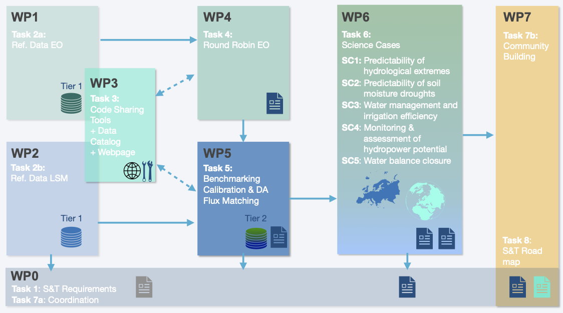
- WP0: Management and coordination activities (L. Samaniego and Almudena Garcia-G).
WP0 is in charge of the coordination of the project and the communication of between project partners and with ESA delegates.
- WP1: Common EO Reference Dataset Generation (Kevin Larnier – CSGROUP).
WP1 will build up an open-access reference dataset over the regions of interest, composed of high resolution Earth Observations data. - WP2: Reference Data Land Surface Models (Marc Bierkens and Bram Droppers – UU).
WP2 will collect community reference simulations from all participants of the modelers partners and prepare a common ancillary datasets for the future high resolution simulations. - WP3: Community Open Science Data & Code sharing Tool and Website (Olivier Koko – CSGROUP and Riccardo Rigon – UT).
WP3 will develop a Community Open Science Data and Code sharing Tool offering easy access to the EO and non EO datasets, code and model results. - WP4: Community Round Robin Exercise (Pietro Stradiotti and Wouter Dorigo – TUW)
WP4 will develop a round-robin intercomparison methodology to identify the most suitable EO datasets for the model benchmarking and assessment activities, and to use in the science cases. - WP5: Benchmarking and Data-assimilation experiment (Oldrich Rakovec –UFZ and Stefan Kollet – FZJ)
WP5 will perform a model benchmarking exercise assessing the impact and performance of different models before and after using the different high-resolution EO products through a set of various experiments at both regional and basin scales across different spatial resolutions. - WP6: Science Cases (Niko Wanders – UU)
WP6 will investigate the added value of the combination of hyper resolution modeling and high (and lower) resolution EO datasets for various applications including closure of the water balance. Additionally, it will assess the potential for the effective combination of advanced EO products and high-resolution hydrological models for different applications. - WP7: Community Building (Luca Brocca – CNR-IRPI and Mark Bierkens – UU)
WP7 is in charge of coordinating and capitalizing on other relevant ESA activities, projects and results as well as enhancing the communication of 4DHydro activities with the remote sensing and modeling communities.

There are three datasets required to provide the forcing variables for the 4DHydro project.
 Table 2: Forcing variables, units, and long names
