Contracting Institution

Partners


Objectives
ULYSSES is a response to the Invitation to Tender (ITT) of the Copernicus Climate Change Service (C3S) with reference number C3S-432 Lot 3 in June 2019.
It aims at:
- providing a "seamless" multi-model hydrological seasonal prediction system using state-of-the-art hydrological models at 0.1° globally,
- delivering a flexible, agile, and scalable production chain based on experiences gained in the EDgE PoC and the eartH2Observe projects,
- guaranteeing the traceability of the provenance of data by using the ecFlow workflow manager,
- providing a sophisticated quality control software (iLAMB) to check baseline simulations and quantify the spread and percentage of extreme forecasts.
Team members
Coordinator: Luis Samaniego
Service Manager: Stephan Thober
Project Board: LS, ST, Gwyn Rees, Niko Wanders, Christel Prudhomme (ECMWF)
Modellers:
UFZ Luis Samaniego, Stephan Thober, Matthias, Kelbling, Akash Koppa, Robert Schweppe, Ehsan Modiri, Oldrich Rakovec
UKCEH: Gwyn Rees, Eleanor M. Blyth, Matthew Fry, Katie A. Smith, Alberto Martinez de la Torre
UU: M.F.P. (Marc) Bierkens, Niko Wanders, E.H. (Edwin) Sutanudjaja, L.P.H. van Beek
WP0: Management and coordination activities (Leader L. Samaniego)
WP1: Production modeling chain design (Leader L. Samaniego)
WP2: Prototyping (Leader S. Thober)
WP3: Data production (Leader S. Thober)
WP4: Support and help development (Leader K. Smith)
There are three datasets required to provide the forcing variables (Table 2) for the ULYSSES project. All three datasets have to provide the following forcing variables listed in the table below. The unit will be adapted within the ULYSSES modelling chain as required.
 Table 2: Forcing variables, units, and long names
All variables marked with an asterisk are calculated within Ulysses modelling chain from underlying datasets. These are tasmax, tasmin from hourly 2m temperature; sfcWind from U- and V- wind component; and specific humidity from 2m temperature and dew point temperature. Additionally, snowfall, if available, will be used. The complete list of variables thus is:
- total precipitation,
- snowfall,
- 2m temperature,
- 2m dew point temperature,
- 10m_u and 10m_v component of wind,
- surface pressure,
- surface solar radiation downwards,
- surface thermal radiation downwards
The three datasets used are:
- ERA5Land: hourly data at 0.1° spatial resolution from 1981 to as long as available. Description: ERA5Land serves as a reference dataset. It will be used to calibrate all four hydrologic models and bias-correct the other two datasets.
- ERA5T: hourly data at as high spatial resolution as possible, from 2020 to now. Description: ERA5T serves as dataset to generate the initial conditions for the operational forecasts because ERA5Land is not updated as a nowcast.
- ECMWF-S5: hourly at as high spatial resolution as possible, from 1993 to now. 51 ensemble members and six month lead time is planed to be used. Description: ECMWF-S5 serves as seasonal forecasting dataset with in ULYSSES.
The ULYSSES modeling chain will allow C3S to
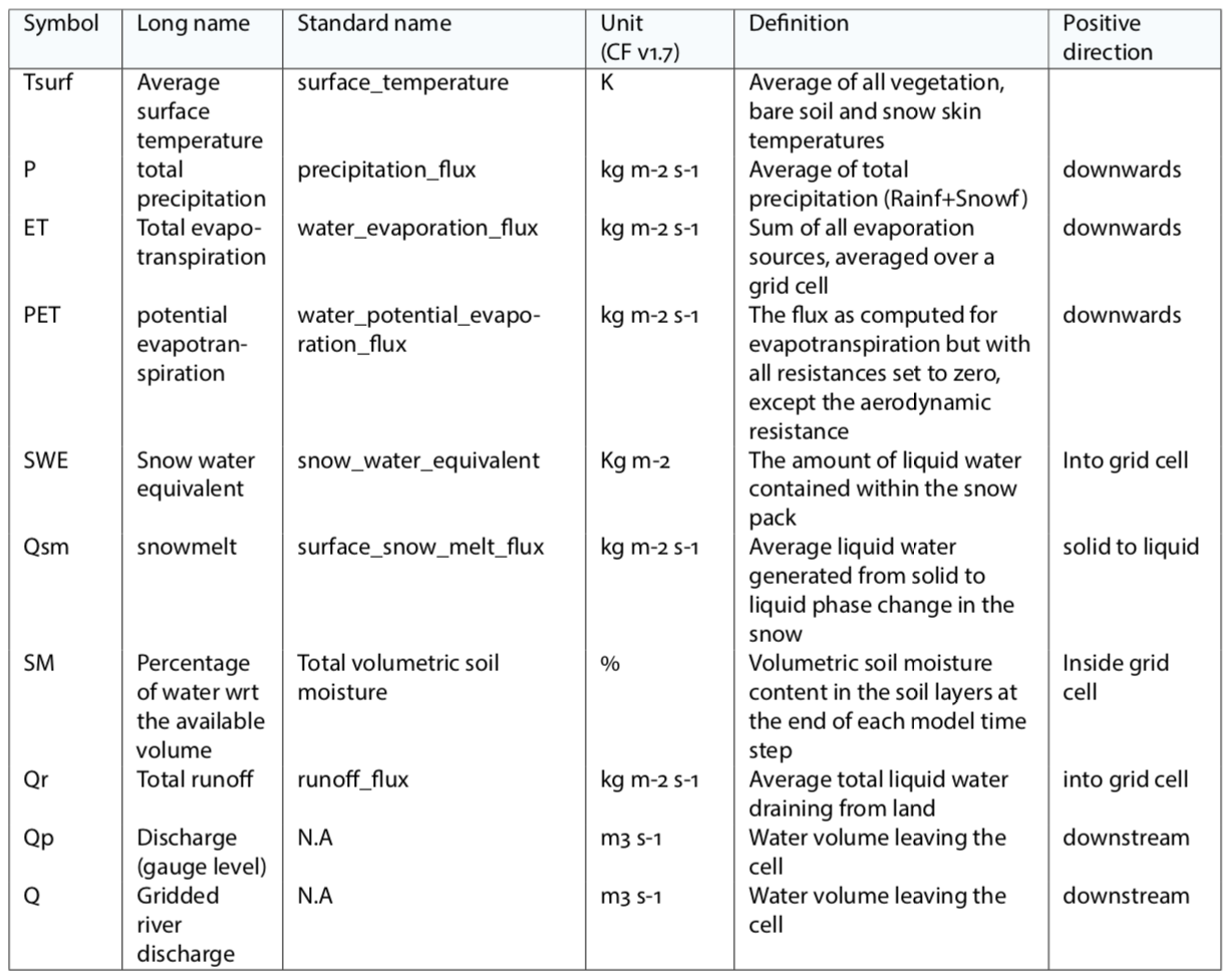
- Provide hindcasts and operational seasonal forecasts of hydrologic variables listed in Table 1 with lead time of 6 months.
- Generate a consistent set of ECVs based on hydrological simulations driven by ECMWF S5 ensemble forcing data at 0.1 deg global grid and a list of 50 selected stations.
- Provide detailed user documentation (e.g. product fact sheets, web stories) on the system: from the establishment of the modelling chain, to case studies on how the data may be used.
- Provide setup of four implemented hydrological models and routing model and tools to update the setup if new datasets from the other Lots of this ITT become available.
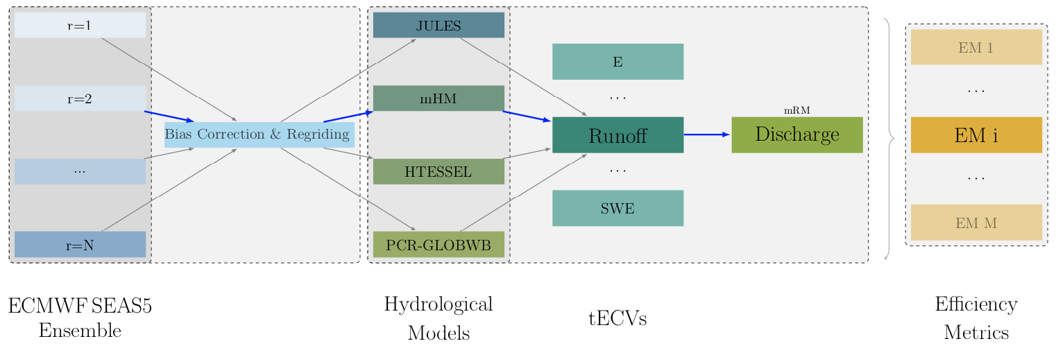
- Provide ecFlow suite for the production chain (see Figure 1).
 Table 1: Essential Climate Variables (ECVs) produced within the ULYSSES production chain. All variables are produced on a global scale at a resolution of 0.1 deg.
 Figure 1: General scheme proposed in ULYSSES to generate an ensemble of hydrologic variables at global scale.
A detailed description of the proposed technical solution can be found in the document below:
