The Terrestrial Water Dynamics team successfully attended the EGU General Assembly 2024 in Vienna! Presenting cutting-edge research and fostering collaborations, we're already looking forward to next year's EGU.
Congratulations to Francisco José Cuesta Valero for being awarded the Alexander von Humboldt Research Fellowship, and we warmly welcome him to join us in October 2021.
MoDEV project kick-off seminar was successfully held on Sep 21, 2021. Four talented and motivated phd candidates will apply novel model-data fusion methods to better understand environmental variability based on high-resolution remote sensing.
Ludwig, A., Doktor, D., and Feilhauer, H.: Is spectral pixel-to-pixel variation a reliable indicator of grassland biodiversity? A systematic assessment of the spectral variation hypothesis using spatial simulation experiments, Remote Sensing of Environment, 302, 113988, 2024
doi
Schmidt, T., Schrön, M., Li, Z., Francke, T., Zacharias, S., Hildebrandt, A., and Peng, J.: Comprehensive Quality Assessment of Satellite- and Model-Based Soil Moisture Products against the COSMOS Network in Germany, Remote Sensing of Environment, 301, 113930, 2024
doi
Almudena García-García, Francisco José Cuesta-Valero, Diego G. Miralles, Miguel D. Mahecha, Johannes Quaas, Markus Reichstein, Jakob Zscheischler and Jian Peng. Soil heat extremes can outpace air temperature extremes, Nature Climate Change
(doi)
Cuesta-Valero, F.J., Beltrami, H., García-García, A., Krinner, G., Langer, M., MacDougall, A.H., Nitzbon, J., Peng, J., von Schuckmann, K., Seneviratne, S.I., Thiery, W., Vanderkelen, I., & Wu, T.: Continental heat storage: contributions from the ground, inland waters, and permafrost thawing. Earth System Dynamics, 14, 609-627, 2023.
Mahecha, M., Bastos, A., Bohn, F., Eisenhauer, N., Feilhauer, H., Hartmann, H., Hickler, T., Kalesse-Los, H., Migliavacca, M., Otto, F., Peng, J., Quaas, J., Tegen, I., Weigelt, A., Wendisch, M., Wirth, C., (2022):
Biodiversity loss and climate extremes — study the feedbacks, Nature, 612, 30-32, 2022.
Lange M, Feilhauer H, Kühn I, Doktor D (2022):
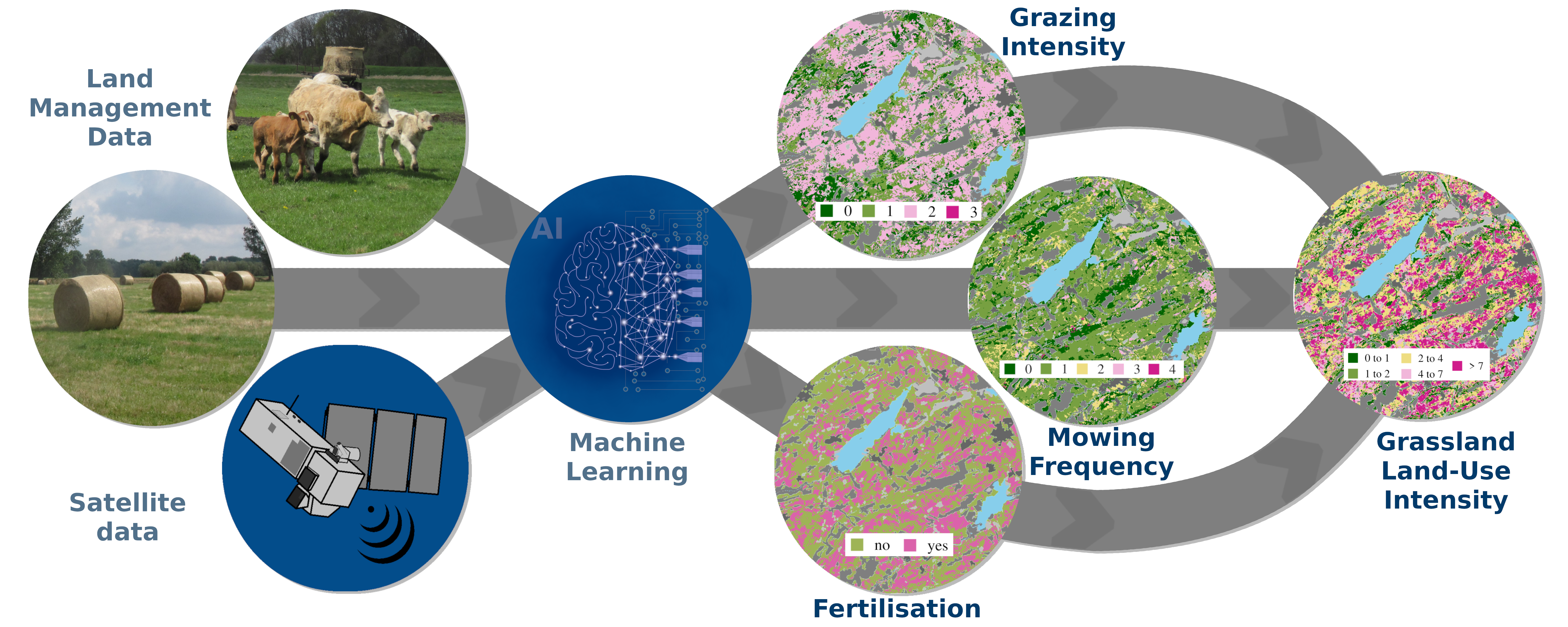
Mapping land-use intensity of grasslands in Germany with machine learning and Sentinel-2 time series.
Remote Sensing of Environment 277,112888
(doi)
Peng, J., Albergel, C., Balenzano, A., Brocca, L., Cartus, O., Cosh, M.H., Crow, W.T., Dabrowska-Zielinska, K., Dadson, S., Davidson, M.W.J., de Rosnay, P., Dorigo, W., Gruber, A., Hagemann, S., Hirschi, M., Kerr, Y.H., Lovergine, F., Mahecha, M.D., et al., (2021):
A roadmap for high-resolution satellite soil moisture applications – confronting product characteristics with user requirements.
Remote Sensing of Environment, 112162
(doi)
Balenzano, A., Mattia, F., Satalino, G., Lovergine, F.P., Palmisano, D., Peng, J., et al., (2021):
Sentinel-1 soil moisture at 1 km resolution: a validation study.
Remote Sensing of Environment, 263, 112554
full text (doi)
Huang, J., Zhang, Y., Bing, H., Peng, J., Dong, F., Gao, J., & Arhonditsis, G.B. (2021):
Characterizing the River Water Quality in China: Recent Progress and On-Going Challenges.
Water Research 201: 117309
full text (doi)
Ayalew, D.A., Deumlich, D., Šarapatka, B., Doktor, D., (2020):
Quantifying the sensitivity of NDVI-based C factor estimation and potential soil erosion prediction using spaceborne Earth observation data
Remote Sens. 12 (7), art. 1136
full text (doi)
Preidl, S., Lange, M., Doktor, D., (2020):
Introducing APiC for regionalised land cover mapping on the national scale using Sentinel-2A imagery
Remote Sens. Environ. 240 , art. 111673
full text (doi)


