Overall objectives of the project
- Optimisation and validation of satellite-based environmental data services for official water monitoring
- Making remote sensing products usable for water management practice through application recommendations and corresponding practical tools
- Harmonisation of the application of remote sensing methods across countries
- Exemplary technical implementation of corresponding operational systems for the authorities
Thematic areas
Satellite-based remote sensing of inland waters focuses on two important thematic areas relevant to water management
1. water quality:
With regard to water quality, the measurands water temperature, visibility depth, turbidity, chlorophyll and cyanobacteria are defined as target variables for satellite-based monitoring. Important fields of application are trophic classification, bathing water occurrence, and the development of water bodies on intra- and interannual time scales. Due to the available spatial resolutions of the satellite products, lakes and reservoirs as well as isolated water bodies in the lower reaches of large rivers are initially the focus of the project. An extension of the methodology to other large watercourses would be conceivable, e.g. within the framework of a supplementary observation of the practice partners with additional financial expenditure.2. water surface extent and its dynamics:
The central objective of this thematic area is, on the one hand, the spatial delimitation of water surfaces. The recording of the spatial extent of water surfaces is particularly relevant in practice in a dynamic context, e.g. for the measurement of flood areas or the level fluctuations of reservoirs and lakes. Finally, drone-based methods are also used in sample applications. They are used to record the fine-structural components of water bodies, such as bank structures, green strips or buildings, and supplement the satellite-based remote sensing products with high-resolution spatial information on decision-relevant scales.Work Packages (WP)
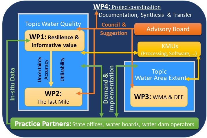
WP1 Resilience & informative value of satellite remote sensing products for water quality monitoring
The UFZ is mainly responsible for the very extensive WP 1 and is supported by the project staff at the ISF in Langenargen and at the HU in Hamburg. The results from this WP are continuously made available to WP 2, from where regular feedback is given to WP 1.
The tasks in WP 1 include:
- Compilation of water quality data from approx. 100 lakes and dams as a basis for the validation of remote sensing products.
- Comparison of methods for processing remote sensing data for selected water quality variables and their optimisation on the basis of in-situ monitoring data.
- Evaluation of the applicability of the optimised remote sensing products for water quality monitoring and water management practice
- Development of recommendations for the methodology of satellite-based remote sensing and for harmonised implementation in official practice, as well as concepts for operationalisation.
Editing: Susanne Schmidt (UFZ) and Rebecca Kutzner (LUBW)
In the AP, which is being worked on primarily by the partner at HU, the practical application of remote sensing in administrative practice in Germany is to be improved. For this purpose:
- determine the need for satellite-based remote sensing of water quality at the federal state authorities in Germany
- an overview of the requirements for the use of the remote sensing products from the Copernicus project will be compiled and the need for new products and applications will be identified
- developed concepts for the technical implementation
Editing: Werner Blohm (HU), Pia Laue (HU)
Work package 3 is implemented under the responsibility of the LfULG. The LUBW also contributes to this work package in the field of remote sensing by drone. However, the main focus of the work package is on the development and provision of a satellite image-based technical procedure for the derivation and representation of the dynamics of watercourse masks. In this way, it will be possible to analyse individual water bodies in detail on a multi-temporal basis. In addition, future users will be provided with a tool that enables a quick and comprehensive view of all water bodies under investigation. The smaller part of the work package, processed by the LUBW, is to determine fundamental questions of the application of UAV data in the context of water bodies and to test application cases. At this point, interfaces between products from drone remote sensing and the monitoring of water body area extent can be elicited and enlivened.
Important individual tasks on the way to achieving the goal are:
- Creation of a coordinated concept for professional development and technical implementation
- Algorithm development and validation as well as establishment and use of a data infrastructure
- Provision of a service for monitoring the extent of water bodies in a suitable technical form.
- In the field of drone remote sensing, determination of requirements and testing of application examples
Processing: Achim Six (LfULG)
WP4 focuses on public relations and knowledge transfer. For this purpose, user guidelines and recommendations for action are developed in discourse with water management practice. These activities are accompanied and supported by project and hands-on workshops.
Editors: Karsten Rinke, Kurt Friese, Désirée Dietrich (UFZ)
Organigram

