WP E Groundwater System
October 2017 - December 2017
In the last Quarter of the year 2017 further advancements have been made in the development of the Chaohu Groundwater Model. A number of the model setups have been run for a simulated time of around ten years. They clearly show a change in the Lake-Groundwater-Interaction during times where strong precipitation leads to a quick rise in surface water levels, while the groundwater recharge process and groundwater transport process have a slower impact on the groundwater level. This is reflected in Fig. 1, where the flow directions at two different moments in a simulation are shown. The precipitation in the days leading to the situation on the left side, were groundwater exfiltrates into the lake, was significantly lower than the precipitation in the days leading to the situation on the right side, were lake water infiltrates into the underlying ground.
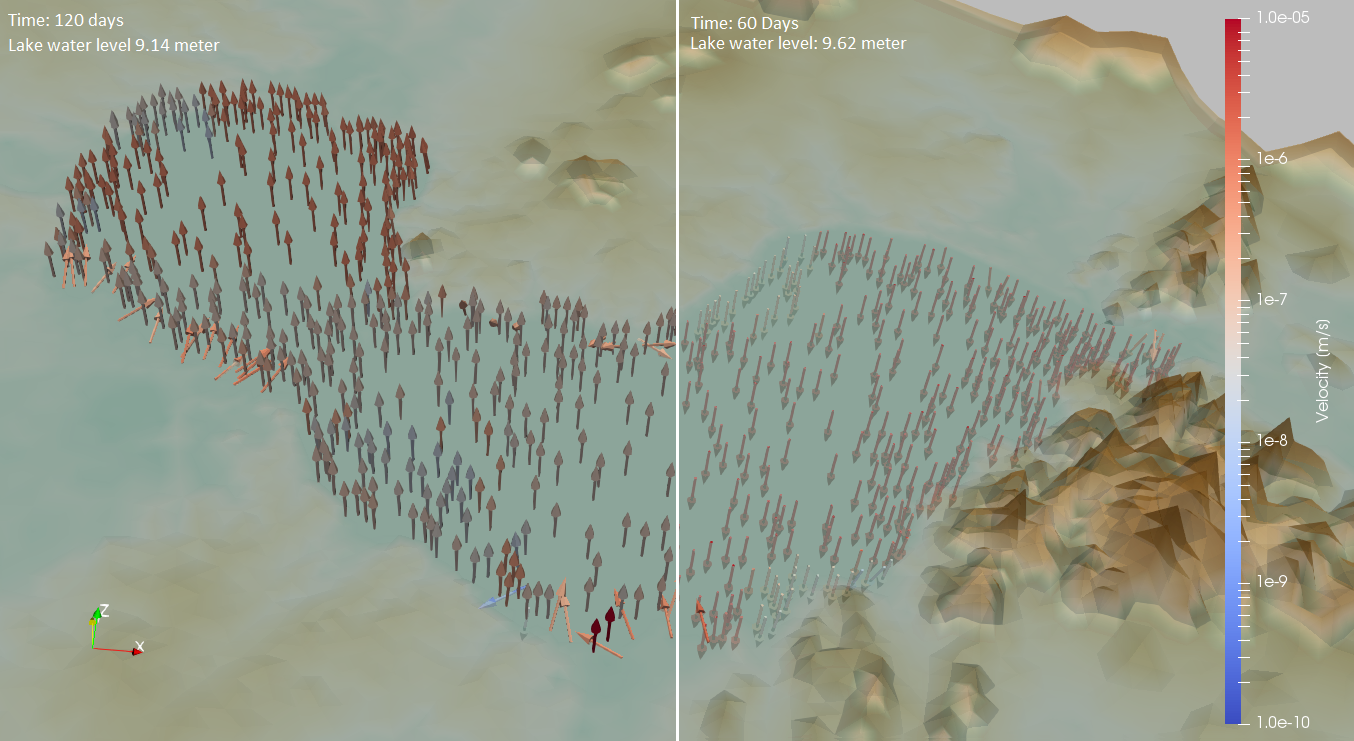
Fig. 1: Exfiltration of GW into the lake at 120 days simulated time (left) and infiltration of lake water into the subsurface at 60 days simulated time (right)
Different model setups have been created and run, to account for uncertainties in the available data and the hydrogeological and mass transport properties that this data represents. An exemplary comparison of the results of two setups in regard to the Lake-Groundwater-Interaction can be seen in Fig. 2. Here a decrease of the hydrogeological property of specific storage from one setup to the other results in an overall larger outflow of lake water into the surrounding groundwater in the observed timespan. This differences naturally also affect the mass transport by advection and are therefore of interest for the spreading Microcystin.
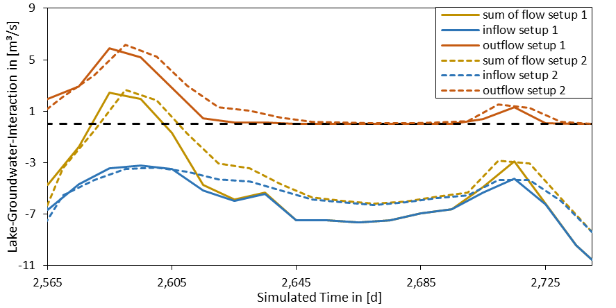
Fig. 2: Comparison of flow from Lake to GW (positive) and from GW to lake (negative) from two model setups
July 2017 - September 2017
Since the successful meeting with the Chinese Partners in May 2017, enormous efforts have been spent to implement the mass transport simulation to assess the microcystin contamination of the groundwater domain in the lake Chao area being a main focus of WP-E. Fig. 1 shows an overview of a conservative tracer substance and the diversity of the groundwater contamination along the lake, which especially can be attributed to varying river water levels.
An essential step was the setup of a transient groundwater flow model: due to the generally plain study domain, the groundwater system in this area strongly depends on surface waters and their respective variable water levels. This, in turn, governs short to medium term groundwater flow regimes (flow directions and velocities) especially in the vicinity of lake Chao. The results need further evaluation, but are a direct outcome of the sincere support and commissioning of time series for the lake Chao water levels of the Chinese cooperation partners at the NIGLAS institute (Prof. Hu).
Another fundamental step was the delineation of a suite of benchmark setups from published literature which mainly focuses on selected processes that have individually different relevance for the microcystin transport and decay. These laboratory scale test setups can be used to infer sensitive degradation and adsorption parameters of microcystin. The parameters can then be attempted to be transferred to a field-scale application. Additional efforts are currently carried out to generalize the laboratory-scale findings for a broader use in our simulations in the study area.
With the transient groundwater flow model and the preliminary information from the published laboratory experiments, we were able to drive a transient mass transport model. The setup aims to evaluate the hypothesis that lake Chao is the unique source of microcystin for the groundwater by employing both, a conservative tracer and reactive solutes in the heterogeneous groundwater domain. These first, preliminary results hint that, although slight encroachment of microcystin in near-lake groundwater reaches is happening, the lake may not be the only source for contamination. Fig. 2 shows a close-up view of a river reach in the southern part of lake Chao: the variation of hydraulic head (esp. lake water levels) are encoded with normalized concentrations of a reactive solute (degradation rates based on published experimental information) that regularly encroaches the aquifer due to varying flow conditions. Further simulation efforts are necessary to assess the microcystin transport, especially the sensitivity of conservative and reactive mass transport parameters.
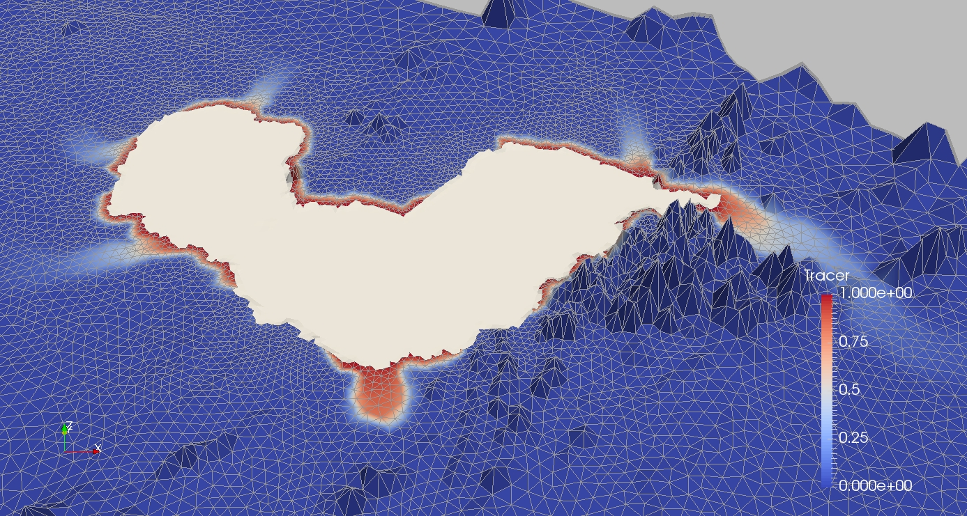
Figure 1: Result of conservative tracer simulation in Lake Chao catchment area
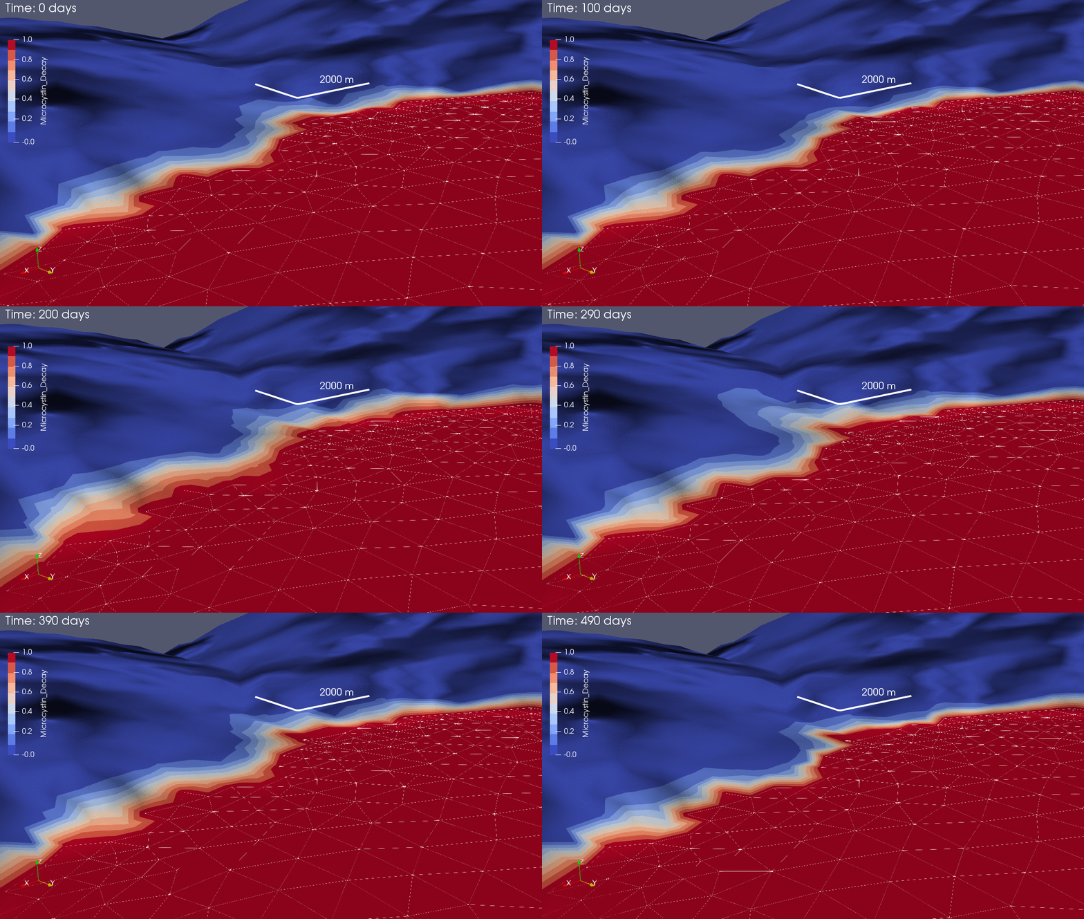
Figure 2: a close-up view of a river reach in the southern part of lake Chao
Mid 2017
In the course of the Workshop “Sino-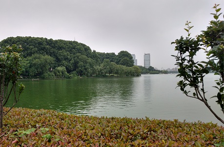 Figure 1: A view of Xuanwo Lake in central-northeast Nanjing (Photo by Marc Walther, May 2017)German Cooperation in the Major Water Program”, which took place at the Tongji University in May, we were able to present first results of TP-E to a delegation of the Saxon State Minister for Environment and Agriculture, and to expand the cooperation with the Nanjing Institute of Geography and Limnology, Chinese Academy of Sciences (NIGLAS). This lead to an additional meeting between the group working on Work Package E and the NIGLAS research team lead by Prof. Weiping Hu. The meeting took place in the city of Nanjing, the seat of the institute, shortly after the end of the Workshop.
As main result of the discussions between both teams, an exchange of measurement data and groundwater model results was agreed upon.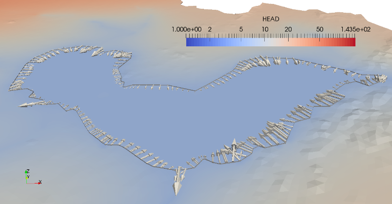 Figure 2: The groundwater flux into Chaohu Lake is around 7.96 m³/s, according to the current (June 2017) steady state model. In addition the need for further measurements in the region in regards to the groundwater situation was noted, as the current availability of data is very limited. Nonetheless the first batch of measurement data, which contain surface water level timelines, was delivered a few days after the meeting. They make it possible to create a transient groundwater model. Furthermore, based on the steady state groundwater model, a first estimation of the flux between Chaohu (Lake) and the aquifer was delivered, as requested by Prof. Hu.
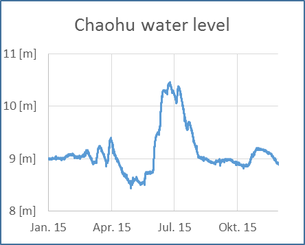
Figure 3: Chaohu water level (according to Wusong vertical Datum) near Zhongmiao (Temple of Loyalty).
Meanwhile the work on the transient groundwater model is in progress. It will allow better statements regarding the flux between the lake and the aquifer. The strong seasonal differences in precipitation and water level give reason to expect significant fluctuations regarding the direction and magnitude of the flux, which implies significant differences in comparison to the steady-state model. It will also be used to improve the understanding of the contamination of the groundwater with the algae toxin Microcystin.
March 2017
The Chaohu groundwater model is a central component of the „Work Package E“, which was added recently as a consequence of new insights from the ongoing project and from research done in the region.
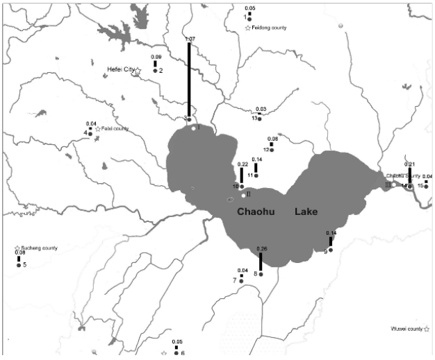
Figure: Sampling locations in Lake Chaohu watershed and their microcystin concentrations in September 2013 (Yang et al. 2016)
There are two essential tasks for the groundwater model. One task is to expand the knowledge of the connection between the urban sewage system (Work Package A) and Chaohu Lake (Work Package C). Urban wastewater is suspected to be a significant contaminator of Chaohu Lake, either by leaking sewers or by direct seepage into the groundwater. The other task is to simulate the transport, sorption and degradation of the algae toxin Microcystin in the aquifer. Microcystin is a product of regularly occurring algae blooms in Chaohu Lake and was found in worrying concentrations in the groundwater (Yang et al. 2016). Groundwater is a source for drinking water in the rural areas around the lake and is used for irrigation.
The currently used data is mostly composed of satellite images and products processed from satellite images. The main sources are the Digital Elevation Model EarthEnv-DEM90, which is derived from SRTM und ASTER satellite images, the ESA CCI Land Cover dataset, based on satellite images from the ESA Envisat mission and data from OpenStreetMap (OSM), a crowd sourced world map. The land cover is used to estimate the groundwater recharge and for the time being, the OSM data is used as source for the surface water locations.
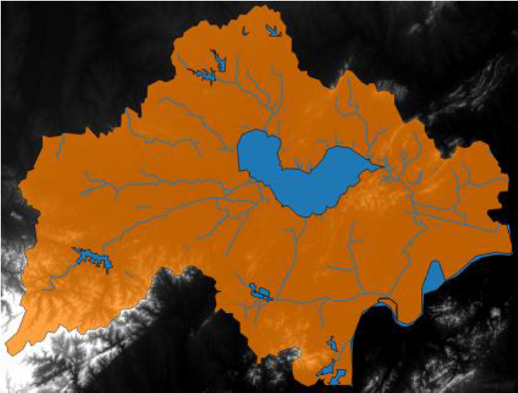
Figure: DEM and OSM data, preprocessed in QGIS
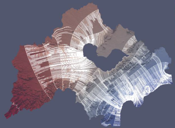
Figure: groundwater simulation results with streamlines (Pohl et al. 2017)
Accordingly, the results of the very first model, which contains hydraulic head boundary conditions for Chaohu Lake plus Yangtze (Chang Jiang) River and a freely chosen uniform groundwater recharge, show a groundwater flow from the west to the east. The next steps include the addition of more surface water boundary conditions and a better estimation of the groundwater recharge, with the help of the land cover data. Additional layers will allow groundwater flow underneath surface water boundary conditions.
Sources:
- Chen, S. & Gui, H., 2015. Hydrogeochemical characteristics of groundwater in the coal-bearing aquifer of the Wugou coal mine, northern Anhui Province, China. Journal
- Yang, Z., Kong, F. & Zhang, M., 2016. Groundwater contamination by microcystin from toxic cyanobacteria blooms in Lake Chaohu, China. Journal
- SRTM und ASTER satellite images (http://www.earthenv.org)
- ESA Envisat mission (https://www.esa-landcover-cci.org)
- OpenStreetMap (OSM) (http://www.openstreetmap.org)
- Pohl et al. (2017) Technical Report, TU Dresden, Contaminant Hydrology.


