WP D Environmental Information System

December 2017
The updated, transient Groundwater Simulation created by TP-E has been integrated into the Environmental Information System. An updated version of the promotion movie for Urban Catchments has also been recorded and edited to demonstrate the progress during off-site workshops and stakeholder meetings. We also prepared a 3D reference as well as supplemental 2D plots for sediment data from the lake for integration into the EIS (see figure below).
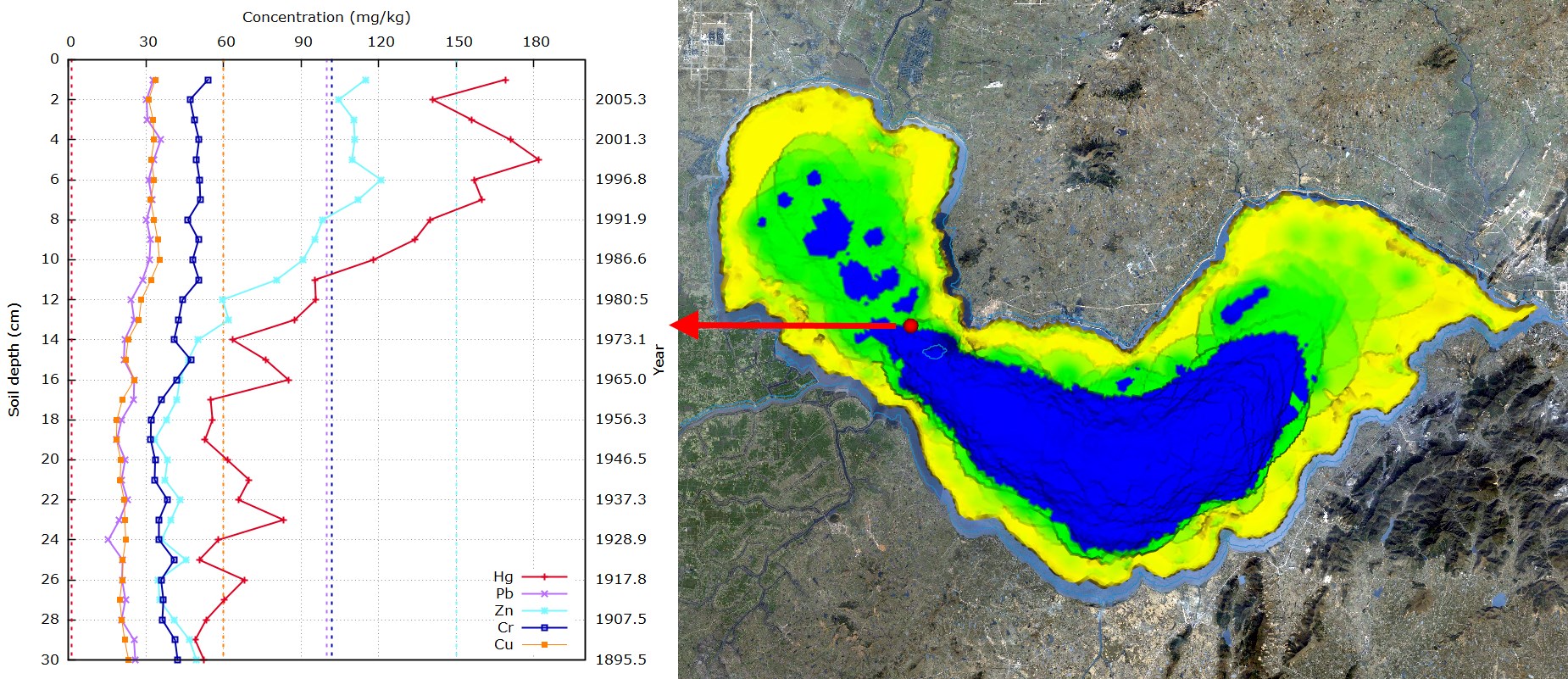
2D plots for sediment data from Chao Lake
A detailed description of the virutal geographic environment has been added as a chapter to the upcoming "Urban Catchments" project book, focussing on the data available and the our approach to integrate this data into a unified geographical context. A shorter version outlining the technical aspects of the data integration process has been propared for the next installment of the "Thermo-Hydro-Mechanical-Chemical Processes in Fractured Porous Media"-series of books.
September 2017
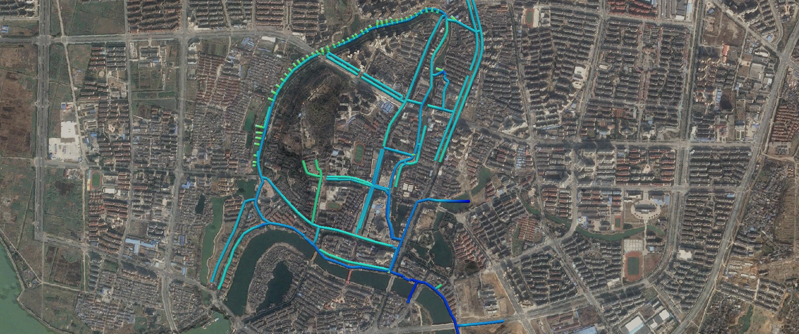
In the past months, previously integrated interfaces to simulation software packages have been extended and basic user interfaces for easier handling by non-experts have been added. A SWMM-Model for the Chaohu city centre was provided by our project partners at Tongji University and has been integrated into the virtual environment (see figure above). We also added a preliminary version of the groundwater model for the Chao Lake catchment prepared by TP-E into the system. Both groundwater head and an animated visualisation of annual changes to flow direction now give additional context to the previously collected data for the lake.
In addition to the software development, a book chapter on the Virtual Geographic Environment has been prepared for the upcoming book on water management in Chaohu. We also provided support for visiting guest researchers from Tongji University and Shandong University to teach the technical requirements for using our workflow and software to create virtual geographic environments for other regions.
June 2017
Multiple interfaces to simulation software used by researchers within the project have been added to our workflow. This includes an interface to the Stormwater Management System (SWMM) used in TP-A for the simulation of a multitude of parameters in channel and sewage networks. This includes typical hydrological parameters such as evaporation, infiltration, runoff or flow velocity, but also the concentration of numerous pollutants in the water.
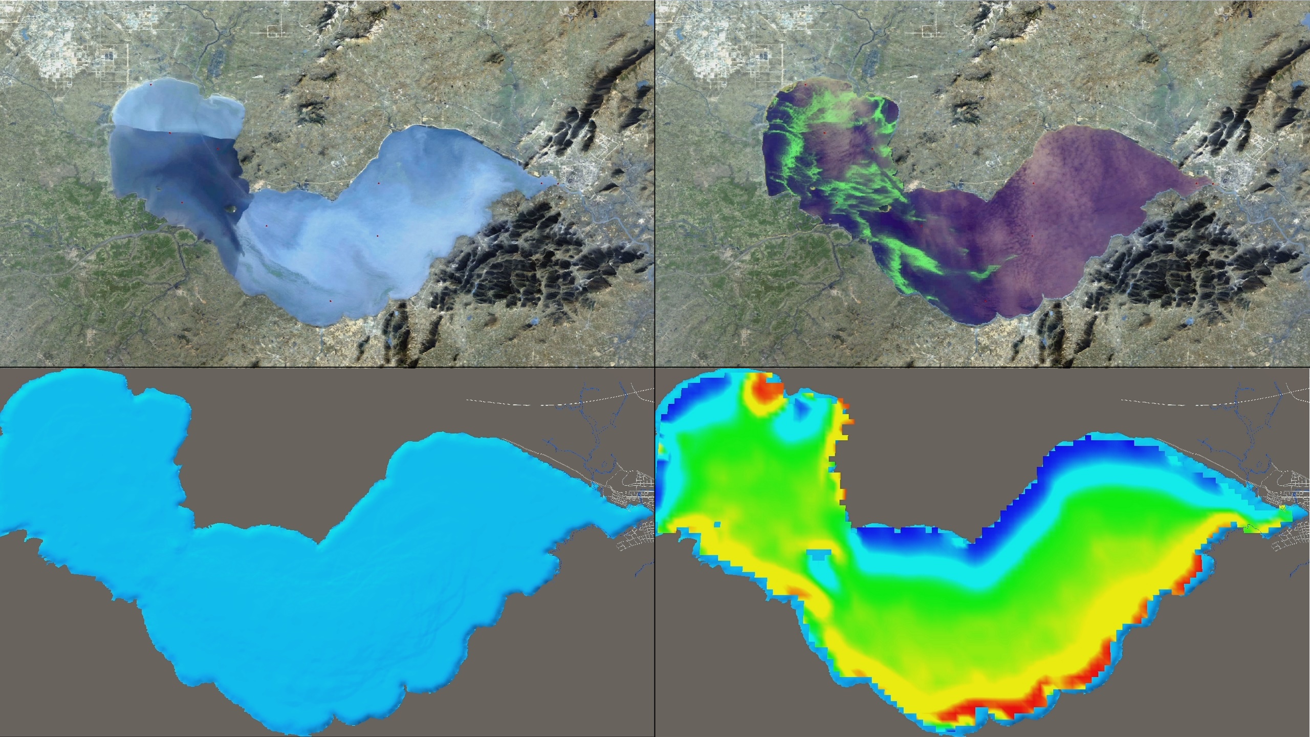
TP-C employs the http://www.getm.eu/(GETM) for studying Chao Lake. An interface to import the simulation results into the EIS allows users to assess the situation of the lake completely: The aerial image (upper left) provides a general overview, including a buoy network and the parameters observed. A high-res bathometry (lower left) shows the structure of the bottom of the lake. LANDSAT data (upper right) allows to illustrate the situation in past years, showing algae blooms and the increasing pollution of the lake. Finally, the GETM simulation data (lower right) visualizes possible future scenarios incl. the remediation potential for the lake.
A groundwater model is being developed by TP-E and is currently in the process of being integrated into the system.
A promotional video demonstrating the current state of the Environmental Information System has been put together and is now available via YouTube and YOUKU. It shows the seamless integration of monitoring and simulation data and has been presented at a number of scientific symposia and conferences in both Europe and China to demonstrate the state of the Urban Catchments project.
July 2016: UC-EIS 1.1 (Presentation at Digital Earth Summit in Beijing)
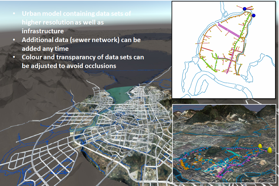
The new version of the UC EIC 1.1 includes more data about infrastructures of the City of Chaohu. On the right the river courses and road network have been added to the land use information. All data are mapped to the DEM. The upper right figure shows a detail of the sewer network which has been used for modeling (source TONGJI University, courtesy Prof. LIAO). The lower right figure depicts the new data set in the geographic context of the UC EIC (the yellows marks indicate pumping stations). Currently a SWMM interface is implemented into the OGS DataExplorer – the data integration engine for the environmental information system. Next steps of UC EIC include the integration of following data sets: high-resolution bathymetry of Lake Chao, water quality models of river courses (in cooperation with TONGJI), the complete sewer network (in cooperation with ITWH) etc. The Urban Catchments Environmental Information System has been presented at the Digital Earth Summit beginning of July in Beijing.
March 2017
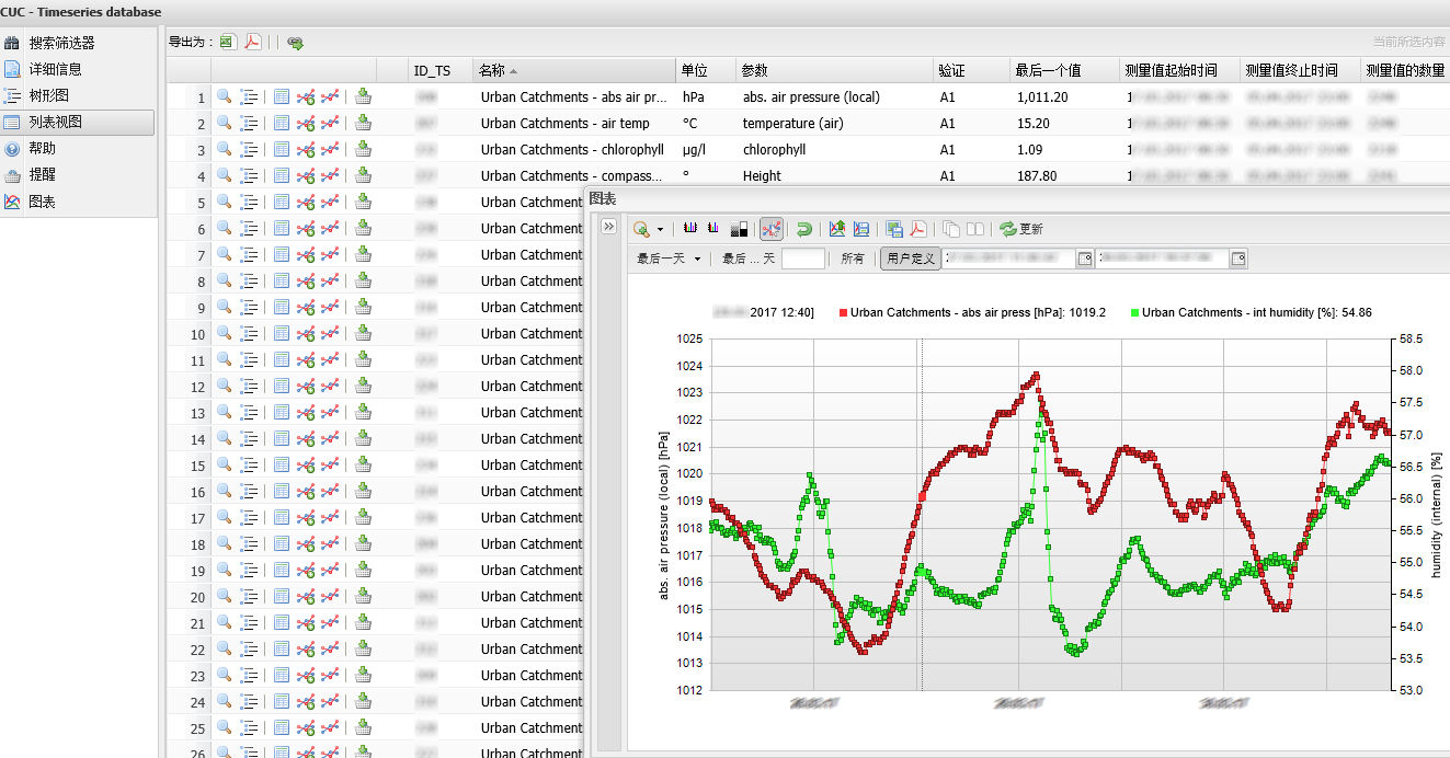
Foto: AMC & WISUTEC
For the demonstration of a measuring station which is going to be installed in the city of Chaohu, the Institute of Urban Water Management, TU Dresden, has constructed a reference system at a small stream ‘Lockwitzbach’ in Dresden, Germany. The programmable measurement and control systems are protected within a control box shown in Fig ①. The in-situ quality sensors are fixed to a concrete plate and covered by a metal cage against floating objects shown in Fig ②. After a short span of time, the device for measuring the quantity (e.g. velocity) will be also added.
January 2016: Präsentation of the Urban Catchmens Environmental Information System (UC-EIS 1.0)
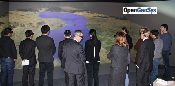
Demonstration of the Chaohu Environmental Information System (EIS) in the UFZ Visualization Centre VISLAB
April 2015: Concept of the Urban Catchments Environmental Information System (UC-EIS)
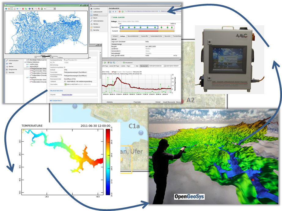
Illustration of the Environmental Information System concept

