What’s in the modules?
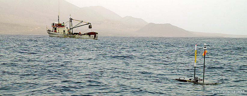
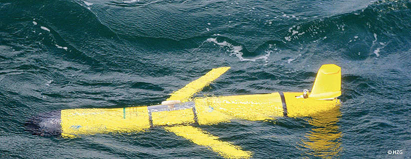
The module comprises autonomous sensor platforms that operate in the
ocean (Ocean Gliders) and at the ocean surface (Wave Gliders). Both
platforms will be equipped with physical/chemical sensor packages for
studying physical-biogeochemical coupling and the ocean’s sink/source
function for greenhouse gases. Several AUVs for multi-parameter
physical/chemical studies and acoustic/optical mapping will operate at
depths of up to five hundred meters. Small robots for physical/chemical
profiling will be used to create spatially highly resolved observations
of small-scale patterns such as fronts.
Fixed-point observatories are stationary platforms equipped with physical, hydrological, biogeochemical and biological sensor systems that serve to monitor the long-term development of environmental conditions as well as their variability on event-related time-scales. These observatories will deliver data beyond point measurements by being equipped with vertical profiling sensor elevators and autonomous underwater robots for three-dimensional surveys. Buoys and landers will be equipped with fuel cell technology to ensure a reliable, steady, and substantial power supply for energy-intensive units like cameras.
Instruments carried on manned mobile platforms are an essential observation component for oceans and coastal areas. These platforms include oceangoing and coastal research vessels, fast and mobile inflatable boats, airplanes, a zeppelin, and mobile laboratory containers. These platforms complement observations from stationary platforms and autonomous vehicles and are currently the only way to carry out targeted observations of distinct events with very high-resolution in space and time. Sensors carried by these platforms measure physical, biogeochemical and biological variables.
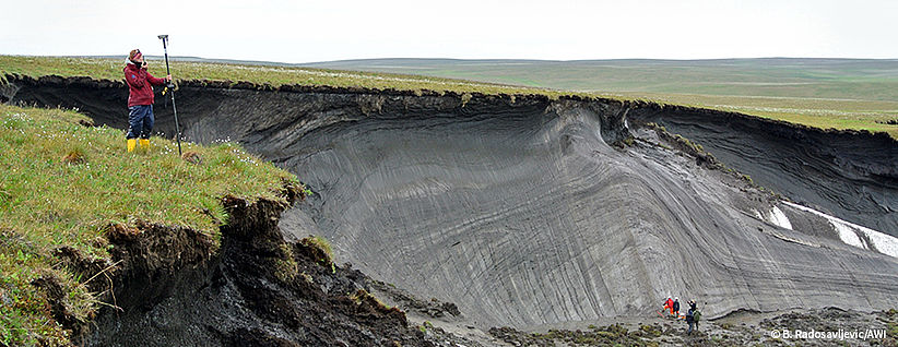
The physical characteristics of permafrost surface (microtopography), subsurface (thermal state, ice and water content, depth to frozen layer) and thaw (thermokarst, subsidence, erosion) will be quantified using terrestrial laser scanning (TLS) and structure from motion technology (SfMt) using image sequences. The upper thawed layer (1 m) will be equipped with temperature, soil moisture and heat flux sensors. A coring device (10 m) will enable access to deeper physical permafrost properties. Aquatic broadband seismic sensors will map the permafrost depth and thaw across the terrestrial and aquatic boundary, in shallow submarine regions and lakes.
The module is designed to observe the space-time variability of flow and sediment characteristics during flood as well as low flow events. It consists of equipment (ADCP, Large-Scale Particle Image Velocimetry camera, time-lapse and stereogrammetric cameras, pressure sensors, CTD sensors, sediment traps, water samplers) to monitor rivers and coastal waters. The module is deployable from upstream catchment areas to downstream river floodplains, lakes and coastal waters.
The terrestrial vegetation dynamics will be monitored with optical, multi-spectral, IR and thermal sensors installed on drones. The spatial-temporal patterns will be used to infer soil water availability within the root zone and to assess biomass productivity and fitness. Deciphering the dynamic relationships between community structure and ecosystem functions during heat waves and hydraulic extremes will be made possible by profiling the soil and water microbiome via portable genomic and transcriptomic sequencing and LC-MS/MS-based metabolomic platforms. The impact of events on water quality and aquatic ecosystems will be investigated in situ with mobile mesocosms and remote-controlled vertical profiling high-resolution stereoscopic cameras.
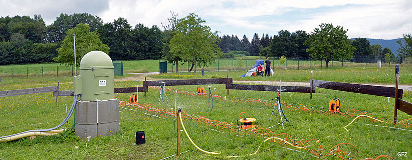
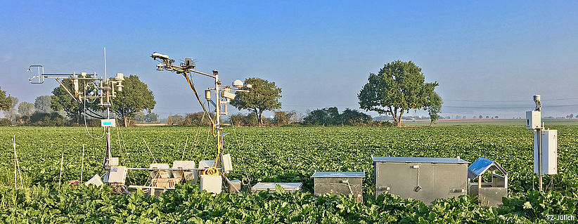
The module comprises geophysical sensor systems (ERT, GPR, cosmic-ray neutron probes, gravimeters) for monitoring changes in soil moisture and total water storage variations. The equipment setup facilitates measurement of these variables from the point scale to the catchment scale. The equipment enables assessment of catchment wetness conditions that trigger the formation of hydrological extreme events as well as event-induced changes in the water balance.
For the investigation of heat wave and flood impacts on soil and water quality, multi-parameter sensors (nutrients, turbidity, chlorophyll), stable isotope and pollutant measurements and UAV-based monitoring systems will operate as a joint platform. The use of the UAV allows a spatially continuous mapping of proxies for surface water quality.
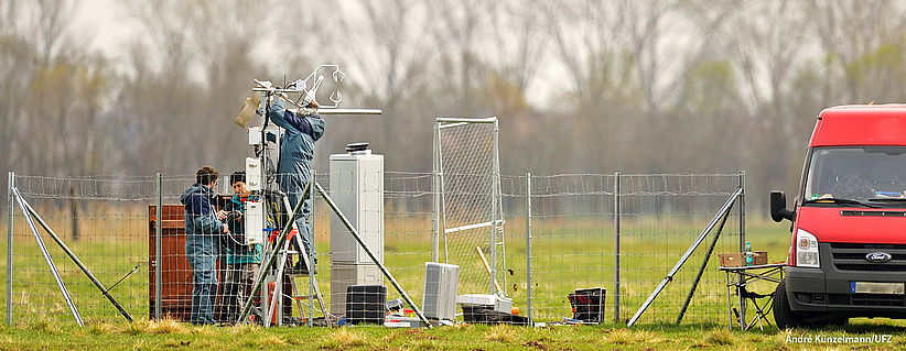
The module comprises mobile systems to measure exchange fluxes (heat, H2O, CO2 and other GHGs, including isotopic signatures) between the land surface and the atmosphere. The MoLEAF Tower units (Mobile Land Ecosystem – Atmosphere Flux Tower) will be developed to ensure swift deployment and self-contained operation with real-time data monitoring for state-of-the-art sensors (e.g. isotope-specific laser absorption analyzers, turbulence sensors). The observing systems include a climatized laboratory container on an all-terrain vehicle and a trailer-mounted pump-up instrument tower (30 m) as well as instruments, computers, power and data transmission equipment. To assess the spatial distribution of atmospheric and terrestrial variables in the tower footprints and between tower sites, miniaturized sensors will be deployed on UAVs or light aircraft.
The atmosphere dynamics infrastructure comprises transportable remote sensing instruments and in situ instrumentation for operation both on the ground and on balloons. Their coordinated operation delivers 3D information on winds from inside and outside rain clouds as well as hydrometeor distribution. A scanning X-Band radar at a wavelength sensitive to precipitation and a scanning IR-Lidar use aerosol scatter. Both can be utilized in dual-Doppler mode and provide important information for nowcasting heavy rainfall. A deployable shelter allows for longer-term operation in areas difficult to access. The balloon instrumentation includes CFH hygrometers for highly precise water vapor values from the ground to the mid-stratosphere and compact optical backscatter detectors for cloud particle observations, in addition to standard radio-sondes and ozone-sondes.
The atmospheric chemistry module provides miniaturized instrumentation for key air quality parameters such as ozone, aerosols and their precursors (NOx, VOC, oxygenated VOC). To fulfill the MOSES requirement of fast and flexible deployment, drones and small balloons are primarily used as measurement platforms. The formation of secondary organic aerosols will be quantitatively assessed by a lightweight and mobile single particle aerosol mass spectrometer. Measurements of tropospheric columns of ozone and other trace gases will be made by mobile spectrometers. These measurements will be complemented by height-resolved profile observations of CO and methane by miniaturized balloon-borne spatial heterodyne spectrometers. All systems are movable.