Soil Science and Site Ecology: Diffuse Pollution
Task
The overall goal for the catchment area of the Western Bug in Ukraine is the enhancement of the water quality of the surface waters within the area under study. The area of main concern for the workgroup Soil Science and Site Ecology is the Bug River itself, parts of which are greatly polluted by point and diffuse sources.
The assignment of the workgroup Soil Science and Site Ecology consists in the simulation of mass balances within the catchment area. The set of task diffuse pressure emphasizes on pollution from agricultural and forested areas. In general, diffuse sources are responsible for higher nutrient, pesticide and bacterial pollution. Besides the cultivation of crops, livestock farming contributes to increased nitrogen and phosphorous pressure. Surface flow and direct discharge from agricultural land may deteriorate the water quality and lead to eutrophication.
Methods, Models, Approaches
The mass- and water balance model SWAT (![]()
![]() Soil Water Assessment Tool) will be used to simulate the water quality of the Western Bug. On the one hand, it serves for the localization of the main sources. On the other hand it enables the simulation of alternative courses of actions. The aim of the workgroup Soil Science and Site Ecology is to point out strategies for the enhancement of the water quality of the Western Bug in a long-term perspective. These include:
Soil Water Assessment Tool) will be used to simulate the water quality of the Western Bug. On the one hand, it serves for the localization of the main sources. On the other hand it enables the simulation of alternative courses of actions. The aim of the workgroup Soil Science and Site Ecology is to point out strategies for the enhancement of the water quality of the Western Bug in a long-term perspective. These include:
- Effective land management; adapted, optimal fertilization
- Sustainable forest management
- Short rotation coppice (SRC)

Reduction of runoff pollution
Whether an application or implementation makes sense, can be investigated by means of scenario building and model analysis and rated according to the corresponding level of uncertainty.
Results
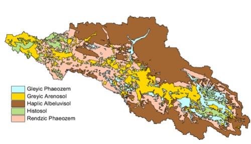
The use of water balance models requires a certain availability of spatial data. One issue among others in the area under study has been the available soil maps, in which only soil under agricultural land was classified. Soil below forests was not depicted. The first aim was thus to generate a detailed soil map of the catchment area for the Western Bug. Soil-physical parameters were also determined, which are necessary for the simulation.
On the basis of a fuzzy logic method (Zhu 1997), a new soil map has been generated for the headwater catchment of the Western Bug (see fig. 1). New soil types have been localized in relation to location, vegetation and/or land use, soil samples and mapping of 34 locations. These results were subsequently applied to the entire area under study.

Fig. 1: Soil map of the headwater catchment in the study area Western Bug
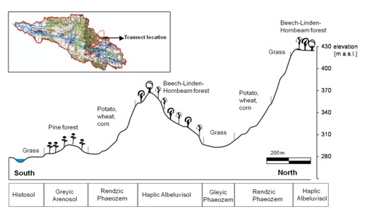
In the context of the soil investigation, a catena regarding typical vegetation and land use has been compiled (see fig. 2). In order to provide detailed input data concerning soil water characteristics for the model, soil-physical parameters have been extrapolated by means of pedotransfer functions. An excerpt of this data is shown in the table below (table 1).

Fig. 2: Catena in the headwater catchment in the study area
Table 1: Effective rooting depth and potential available water capacity (AWC) according to soil type, location and land use
| Soil Type | Landform position | Land use | Effective root depth [dm] | Potential AWC related to maximum root depth [mm] |
|---|---|---|---|---|
| Gleyic Phaeozem | Intermontane depressions, valley bottoms | Grass | 5 | 90 |
| Crop | 7 | 130 | ||
| Pine forest | 12 | 205 | ||
| Greyic Arenosol | Flat plains | Grass | 5 | 85 |
| Crop | 7 | 115 | ||
| Pine forest | 12 | 155 | ||
| Deciduous forest | 12 | 155 | ||
| Haplic Albeluvisol | Slopes | Grass | 8 | 205 |
| Crop | 10 | 260 | ||
| Pine forest | 15 | 415 | ||
| Deciduous forest | 15 | 415 | ||
| Histosol | River near Plains, valley bottoms | Grass | 4 | 110 |
| Crop | 6 | 185 | ||
| Rendzic Phaeozem | Upper slope, plateaus | Grass | 3 | 80 |
| Deciduous forest | 5 | 125 | ||
| Middle slope, steep slopes | Grass | 3 | 80 | |
| Toe slopes | Grass | 5 | 125 | |
| Crop | 7 | 170 |
Editors
Kai Schwärzel
TU Dresden
Institut of Soil Science and Site Ecology
Chair Site Ecology
Pienner Straße 19, Raum 2.35
01737 Tharandt
![]()
![]() kai.schwaerzel@forst.tu-dresden.de
kai.schwaerzel@forst.tu-dresden.de
Filipa Tavares-Wahren
Institution TU Dresden
Institut of Soil Science and Site Ecology
Chair Site Ecology
Pienner Straße 21, Raum E07
01737 Tharandt
![]()
![]() tavares@forst.tu-dresden.de
tavares@forst.tu-dresden.de
Frederike Schumacher
TU Dresden
Institut of Soil Science and Site Ecology
Chair Site Ecology
Pienner Straße 21, Raum E07
01737 Tharandt
![]()
![]() frederike.schumacher1@tu-dresden.de
frederike.schumacher1@tu-dresden.de
Supplementary material
Zhu AX (1997) A similarity model for representing soil spatial information. Geoderma 77:217–242.


.png)
.png)
