Introduction
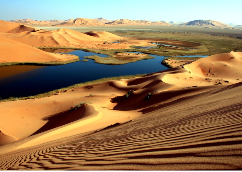
In arid regions available water resources are largely restricted to groundwater. Groundwater recharge is a result of irregular, brief periods of intense rainfall, which is heterogeneously distributed in time and space. Due to high temperatures, high plant transpiration and sparse rainfall, only a small part of this water eventually reaches the groundwater table. Therefore, quantifying groundwater resources is a key issue for the management of the limited water resources in arid regions. Field and numerical investigations show that in arid regions less than 5% of the precipitation contributes to groundwater recharge. As a matter of fact, more than 80 % of water resources in arid regions are used for irrigation in agriculture.
Therefore, developing appropriate methodologies for the estimation of groundwater recharge and sustainable water management schemes are a matter of paramount importance.

Project Area
IWAS Middle East concerns the Kingdom of Saudi Arabia covering the largest part of the Arabian Peninsula (2.2 million km²), and the Sultanate of Oman in the South-Eastern part of the Arabian Peninsula (309,500 km²). Saudi Arabia has an estimated population of 27.6 million people (2007), of which the majority lives in cities (86%) or oases. Its capital, Riyadh counts 4.1 million inhabitants and the country’s population growth rate is around 3%. While the economy relies mostly on the country’s rich oil reserves, Saudi Arabia also strives for independence from water and food imports. In order to cover the country’s needs for food and feed crops, large, water-consuming center pivot irrigation systems are installed in many parts of the hyper-arid country. Groundwater exploitation from wells (82% of water resources) reaching depths as great as 1 km, dams for rainwater harvesting and desalination plants are in place to meet the enormous water demand of around 20 billion m³ per year (2004), of which 86% are used for irrigated agriculture.
Oman’s population is around 3.2 million and it grows at a rate of 3.3 %. The majority lives in urban areas (78%), while around 5% of the population lives as Nomads. Like in Saudi Arabia, Oman’s economy is based on mineral oil exports. Other economic sectors are the exploitation of natural gas reserves, mining activities, as well as – to a small extent - agriculture. Total water consumption is approximately 2 billion m³, of which 83% is used for agriculture.
The Arabian Peninsula is characterised by a wide range of topographic elevation which is related to a wide range of precipitation with an extremely high spatial and temporal variability. Depending on the climatic and hydrogeological conditions, infiltration after rainfall is restricted to the upper-most decimeters and thus the water evaporates from the unsaturated zone. Variations in precipitation, air temperature, root zone, soil properties, faults and fractures and hydrological properties all influence the downward movement of groundwater and consequently, the recharge of groundwater. Investigations showed that according to the geologic structure and the recent low precipitation, many areas present infiltration which decreases below 1 mm/a. While precipitation is slightly higher in the South and West of the peninsula, average annual precipitation is similar in Oman (80-400 mm) and in Saudi Arabia (33-550 mm). Flood flow within the wadis is in many places regulated by dams locally enhancing groundwater recharge.
Aims and Contents of the Regional Project
Estimation of groundwater recharge is a challenging topic for hydrogeologic studies, especially when concerning arid and semi-arid environments, where groundwater resources are limited. IWAS aims at developing appropriate methodologies for the investigation of groundwater recharge processes in such environments as a managerial tool for the quantification of groundwater resources of arid regions.
An important goal of the project is to assess the impact of preferential flow on groundwater recharge as well as local and regional groundwater recharge in arid regions, such as the Arabian Peninsula, depending on the geological environment, the tectonic elements and the geomorphological setting. The existence of preferential flow paths and recharge rates can be verified by the analysis of specific (radio-) isotopes and Rare Earth Elements. Also, IWAS quantifies the impact of vegetation on groundwater recharge, and couples the relevant compartment models (groundwater-soil-plant-atmosphere).
While localised recharge may be restricted to a few millimeters per year, on the large scale this may sum up to substantial amounts allowing the development of sustainable management strategies. Therefore, highly precise large-scale recharge estimations are crucial for the planning of water resources management of the peninsula and other arid regions.
As irrigation makes up by far the largest part of water consumption, there is a substantial need to adapt water management schemes to the scarce water availability. The innovative IWAS water management and long-term planning tool (APPM: Assessment, Prognoses, Planning and Management tool) unites optimal solutions for water allocation, groundwater storage and withdrawal including saline water management with alternative, most beneficial irrigation strategies. The APPM will first be developed in Oman and it shall provide options for evaluating the adequacy of proposed locations for artificial groundwater recharge and flood protection systems. The APPM will consist of three major hydrologic components: 1) a water resources module for artificial groundwater recharge and management as well as flash flood modeling, 2) a module for irrigation control, scheduling and planning, and 3) a technical problem-orientated pipeline system (backbone) for water allocation and distribution.
Partners
Laboratory and field investigations and modeling are carried out by the Helmholtz Center for Environmental Research (Dept. Catchment Hydrology) and Dresden University of Technology. The field investigations in Saudi Arabia are supported by the Deutsche Gesellschaft für Internationale Zusammenarbeit (GIZ) in Saudi Arabia (Riyadh) and Dornier Cosulting. The numerical interpretation of the field data is conducted at the UFZ in collaboration with the University of Darmstadt (Institute of Applied Geosciences, Hydrogeology Group) and in close collaboration with the Lawrence Berkeley National Laboratory (Hydrogeology Department) in Berkeley, CA, USA.
- Technical University of Darmstadt, Institute for Applied Geosciences
- Deutsche Gesellschaft für Internationale Zusammenarbeit, International Services GmbH (GIZ) in Saudi-Arabia and Dornier Consulting
- Lawrence Berkeley National Laboratory, Earth Sciences Division
- Technical University of Munich, Experimental Physics and Astroparticle Physics
- Forschungszentrum Karlsruhe in der Helmholtz-Gemeinschaft
- Ministry of Water and Electricity (MOWE, Saudi Arabia)
- Ministry of Agriculture (Oman)
- Ministry of Regional Municipalities and Water Resources (Oman)
- Ministry of Environment and Climate Affairs (Oman)
- Sultan Quabus University of Muscat (Oman)


Contact and further information
Prof. Dr. Rudolf Liedl (TU Dresden)
![]()
![]() rudolf.liedl@mailbox.tu-dresden.de
rudolf.liedl@mailbox.tu-dresden.de
Dr. Christian Siebert (UFZ)
![]()
![]() christian.siebert@ufz.de
christian.siebert@ufz.de
Prof. Dr. Christoph Schueth (TU Darmstadt)
![]()
![]() schueth@geo.tu-darmstadt.de
schueth@geo.tu-darmstadt.de
Prof. Dr. Randolf Rausch (GIZ)
![]()
![]() randolf.rausch@gtzdco-ksa.com
randolf.rausch@gtzdco-ksa.com


.png)
.png)
