Hydrological Cycle
Introduction
Based on the scenarios developed by the climate and land use groups (work-packages 1 and 2), work-package 3 is responsible for the description and modelling of the hydrological cycle in the Federal District, using all available historical hydrological data. The goal is to simulate the consequences of the changing environment on the future water availability in that region. Existing meteorological and hydrological data will be analysed and calibrated with future climate and land use scenarios. The first goal is to study the interaction of groundwater and surface waters, with a special focus on the dry-season-problem. A further goal is to develop water balance models for surface and groundwater bodies, including the larger reservoirs (Paranoá, Santa Maria and Descoberto).
Objectives
- Collection and evaluation of hydro-geological data in the Federal District
- Development of an extensive groundwater monitoring program
- Collection and evaluation of fluviometric data (surface and groundwater runoff) in the Federal District
- Collection and evaluation of climatic and land use data in the Federal District
- Artificial Recharge: Site-analysis for practicability of groundwater recharge arrangements
- Study of CAESB catchment areas: São Sebastão and subbasin Santa Maria
- Geophysical investigations, landfill-site Brasília DF
Methods and Data
A hydrological balance model (Fig. 1) for flow prediction is developed in some of the catchments managed by the CAESB. Climate, rain and discharge data are used to create surface-runoff SWAT models for Pipiripau, Santa Maria, Descoberto, Paranoá in DF.
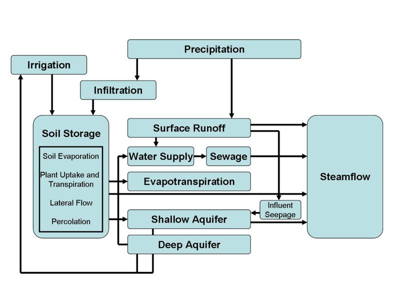
Fig. 1: Schematic pathways for water movement – hydrological balance.
The Pipiripau basin is used as a pilot area for the integrated modelling of groundwater and surface water. The Pipiripau watershed (Fig. 2) is located in the Brazilian Central Plateau and has a drainage area of approximately 21,300 hectares. The main water course is 41 km long and is a tributary of the River São Bartolomeu, one of the most important sources of water in the Federal District.
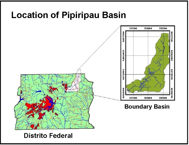
Fig. 2: Pipiripau watershed in Distrito Federal.
The main objective of this work is to develop a method for data integration of groundwater and surface water data of the Pipiripau basin. This method should consider all the characteristics of the physical environment including geological, geomorphologic, climatic, pedologic aspects as well as the type of land use and land cover.
For that, it is necessary to build a Geodatabase including all qualitative and quantitative data on surface and groundwater, with which the main hydrodynamic characteristics of circulation and storage and the hydrologic parameters can be assessed. Furthermore, the parameters that can be used as a basis for determining criteria for granting of permits can be selected; the maximum soil moisture retention according to the curve number method (CN) can be obtained and adjusted to the Cerrado (Brazilian Savannas) conditions. Additionally, it is possible to define infiltration and recharge conditions in the region through water balance and also limits for hydro-geological watersheds or management units based on criteria for homogeneous use in different aquiferous systems/subsystems. The classification of areas of groundwater use according to the pressure on the system is also a task, including aspects associated with water exploitation, impermeabilization of recharge areas and water quality.
Building the Geodatabase involves the storage of all information according to the degree of detail required by the application. Thus, the setting up of the geodatabase for the study area will be performed on a client-server system and will include the following information: slope map, isohyets map, land use and cover map, geological map, hydro-geological map, soil map, recording of outflows of actual and potential catchments, recordings from sewage treatment systems, recordings from wells, in addition to other parameters that might be used to characterize the area's hydrodynamics.
The integration of data and information and the hydrological modelling will be carried out using elements of the IWAS Toolbox.
Test sites
For a feasibility study for artificial groundwater recharge, a test site for long-term monitoring of infiltration processes was established. Near a waste water treatment plant in São Sebastião (37 km SE of Brasília) a test site with two infiltration basins (5 x 5 m) has been constructed. Pre-treated municipal waste water originating from the treatment plant serving the city of São Sebastião and its surrounding areas is used for infiltration. In this treatment plant (Fig. 3) the waste water is treated in three steps. After a first mechanical treatment step the pre-treated waste water is pumped through a temporary basin for anaerobic treatment. Following this, the water is spread over a large area of sloped meadows by a branched piping system where the main part of the treatment of waste water takes place. The waste water percolates through the upper soil layer and gets filtrated in the clayey horizons of the local latosols. To prevent an influence of vegetation on the infiltration at the test site, all plants and the top layer of root-penetrated soil was removed.
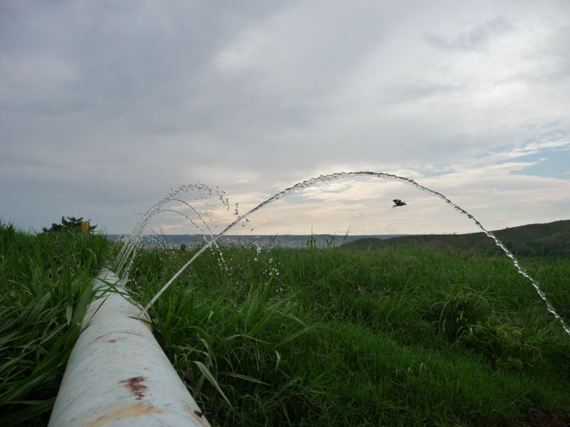
Fig. 3: Waste water treatment plant in São Sebastião near Brasília.
For the observation of the wetting front during infiltration a 3D-geoelectrical monitoring grid with 64 decoders was constructed. The grid (15 x 6 m) is made up of four decoder lines in parallel (Fig. 4). With this set-up an investigation depth of approximately 3 m below ground surface could be reached. The infiltration basins are located in the centre of the 3D monitoring grid. A dipole-dipole electrode configuration was used in this application. The monitoring of the wetting front started with a measurement of the local subsurface electrical resistivity background values. After doing this, the basins have been flooded with pre-treated municipal waste water and repeated measurements of electrical resistivity have been conducted and compared with the background values afterwards. Because of the high nutrient content of the municipal waste water, the electrical resistivity in the soil drops as a function of the infiltration rate. For further investigations, soil samples were taken and will be used for column tests in unsaturated milieu. A combined hydro-chemical and geo-electrical monitoring is planned.
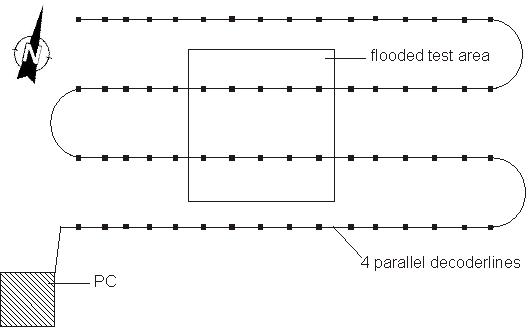
Fig. 4: Schematic overview of the geo-electrical monitoring system
Participating research groups
- Prof. H. Weiss, Helmholtz Centre for Environmental Research – UFZ – Leipzig, Department of Groundwater Remediation
- Prof. S. Koide, Universidade de Brasília (UnB), Department of Civil Engineering
- R. Santos, Companhia de Saneamento Ambiental do Distrito Federal – Brasília (CAESB)
- M. Strauch, Technische Universität Dresden (TUD), Department of Forest Science, Institute of Soil Science and Site Ecology



.png)
.png)
