Hydrological Platform
What it is about
The observation of climate induced changes in the hydrological regime is one of the major tasks within TERENO activities. The detection of scale dependencies in flowpaths, run-off generation or residence times requires scale-related approaches of observation. Therefore, a nested approach including small process plots (< 2 km²), meso-scale subcatchments (approx. 100 km²) up to the catchment scale will be established.
Where it takes place
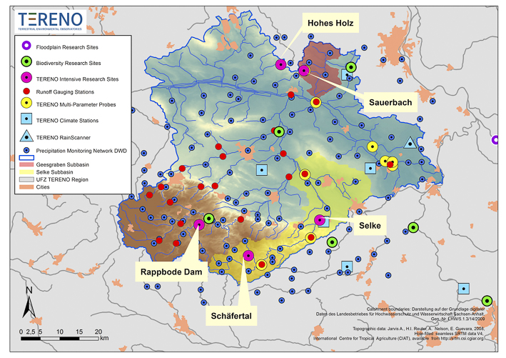
The Bode river catchment is the central study site for water-related research at the UFZ. It is a mesocale, lower mountain range catchment (total area: 3,300 km²) within the Elbe river basin. The area shows large topographic gradients (altitude: 55 - 1,100 m above mean sea level) and climatic variability (mean annual temperature approx. 9°C). Mean annual precipitation amounts to an average 660 mm with large spatial and temporal variability (450 - 1,600 mm; maximum in summer). The Geology of the Bode catchment is dominated by schist and claystone in the headwaters (ca. one third of the catchment area), and tertiary sediments with loess soils in the lower parts of the catchment (ca. two third of thecatchment area). Previous studies concentrate on runoff generation in small headwater catchments of the Bode/Selke River. Digital soil data are available at the scale of 1:50000 for the whole catchment and several long term soil survey filed sites for different soil types within the catchment. The area is dominated by agricultural use (70 % of the catchment). The middle mountain area of the Harz is dominated by forest use. Urban areas make up around 6 % (total population 370,000), industrial areas and open-pit mining areas each cover approx. 1 % of the land surface.  Map Hydrological Observatory Bode
As integral part of the TERENO observation network an integrated monitoring and research concept joining hydrological, atmospherical, biodiversity related, and soil physical research has been implemented. This will lead to scale-dependent intensive research activities on different spatial scales ranging from point sampling to remote sensing, following a nested approach. Thus, it offers the possibility for a joined processing of central research questions from the point via the plot scale up to the catchment scale; and it constitutes one region sensitive to climate change where a regional model will be calibrated and applied for predictive scenarios.
Contact ![]()
![]() Steffen Zacharias,
Steffen Zacharias, ![]()
![]() Ute Wollschläger
Ute Wollschläger
Link - More information is available at ![]()
![]() www.tereno.net
www.tereno.net