Global Ground Heat Flux Estimated from Satellite Remote Sensing Observations
Duration: 2021-10-01 to 2023-09-30
Funding: Alexander von Humboldt Foundation
Motivation
Ground surface flux is the component of the surface energy balance associated to heat diffusion into the continental subsurface by conduction, and together with sensible heat flux and latent heat flux –related to the heat exchange with the lower atmosphere due to advection and evaporation respectively, redistributes the radiation absorbed by the land surface. These three components of the energy balance are interdependent, as changes in one of them directly affect the others, and uncertainties in one of them increases the uncertainties in the rest of components.
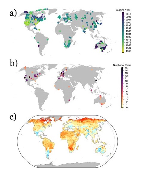
Despite the importance of ground heat flux to understand the evolution of land surface conditions, observations of this heat flux are markedly scarce, with only those provided by the FluxNet network of micrometeorological observatories (around 40-60 sites between 2004 and 2014). Thus, other sources of information are required to understand the long-term evolution of ground heat fluxes. Estimates from the global network of subsurface temperature profiles have become the main source of information about ground heat fluxes at decadal temporal scales. However, the measurements of subsurface temperature profiles are concentrated in North America and the Northern Hemisphere, with the majority of measurements in the Southern Hemisphere limited to Australia and the southern part of Africa. Furthermore, the lack of recent measurements causes that robust information about global ground heat flux is not available after 2000. Therefore, an observational reference covering broader areas is necessary in order to understand how ground heat flux evolves at the global scale, bridging the gap with estimates from subsurface temperature profiles.

Satellite remote sensing products allow to estimate variables such as land surface temperature or evaporation, which are sparsely measured. Although there have been efforts to estimate ground heat flux directly from land surface temperatures retrieved from satellite observations, large uncertainties remain among these products. Indeed, knowledge gaps persist related to the role of land cover and land properties in ground heat flux and in the determination of the radiation reaching the land surface.
Objectives

The proposed line of research explores the benefits of deriving a high-quality global estimate of ground heat flux from satellite remote sensing observations. Furthermore, the proposed research will allow to understand the dynamics of ground heat flux at global scales, as well as bridging the gap between estimates from subsurface temperature profiles and measurements from FluxNet towers. Particularly, this research addresses these concrete goals:
- Assembling accurate estimates of global ground heat fluxes by testing several techniques and satellite products.
- Understanding the role of vegetation, soil moisture, soil texture and other factors in the evolution of ground heat flux at both regional and global scales. Characterizing the daily and annual cycles of ground heat flux.
- Determining the suitability of the estimated ground heat flux for climate change analyses.
