
TiM4Water: Transitions in WATER management
Platform Project - PP5.5
A modular modeling chain to ensure sustainable water management under the influence of climate change and associated uncertainties
Multiple landscape functions are sensitive to the anticipated climate change, esp. the increasing frequency of hydro-meteorological extremes affecting the entire water and energy cycle (surface-, soil-, and groundwater). Thus, climate adaption is particularly urgent in all fields of water resource management (WRM) to assure multifunctionality and has to account for the heterogeneity in the environmental site-conditions. To support this task, PP5.5 tackles management transitions aiming at a climate-adapted WRM, develops tools and workflows for integrating them in landscape simulations, and for predicting their ability to mitigate adverse climate change effects on landscape functions.
Purpose of the Platform Project
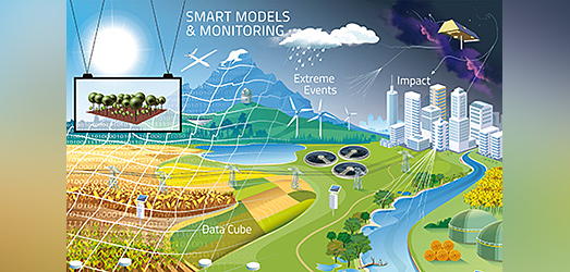
According to projections, climate change will be associated with a significant increase in the frequency and intensity of extreme events like heavy rainfalls, droughts and heatwaves with previously unpredictable consequences and feedbacks. Such events affect the entire hydrological cycle of the Earth with interdependent consequences for the atmosphere, terrestrial and limnic systems. Germany and Europe will have to prepare for very unevenly distributed precipitation and increased extreme events in the future and therefore a chain of intelligent, model- and data-based decision-making tools is needed to manage all water resources appropriately in terms of surplus and demand as well as quality requirements.
The hydrological cycle, i.e. the system composed of precipitation, snow deposition and melting, evaporation, percolation, and runoff, is massively influenced by the physiographic characteristics of the land surface and its land cover/use. Water bodies, aquifers and glaciers constitute large natural freshwater reservoirs, while soils and vegetation interact with this cycle through infiltration, plant water uptake, transpiration, and infiltration. The interactions of the individual subsystems are complex but central for its functioning. Anthropogenic activities and emissions are disrupting theses natural interactions. For this fundamental reason, and considering the ongoing climate changes, our way to interact with it (i.e., to manage) need to be reconsidered in a holistic way. This means that all its components must be examined together before a decision is taken.
Scientific Goals and Approaches
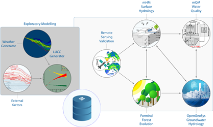
Hence, we aim to develop a seamless hydrological modeling chain ranging from sub-seasonal to decadal time scales and applicable at multiple spatial resolutions. Key components of this chain are climate model outputs downscaled to the target resolution, the hydrological model mHM (including routing mRM), a lake/reservoir model, the OpenGeoSys (OGS) groundwater model, several impact indicators (e.g., SMI) and several impact models targeting a given aspect of the water resources management including economic costs and risks.
In general, we develop software and digital workflows to explore and test possible water resource management options for the future. In cooperation with other Integration Platform Projects (see below) we furthermore stress-test potential decision making choices or key infrastructure design indicators under potential future global climate/social scenarios and considering the propagation of uncertainties along the modeling chain.
Recent Tasks and Fields of Activity
Within the modeling chain, we use ground-based, airborne, and satellite-based monitoring data. Given the global and regional nature of hydrological cycle processes, remote sensing, especially of water and energy fluxes, is very useful for monitoring hydrological cycle mechanisms and their short- or long-term changes. Moreover, additional approaches combining ground-based measurements with remote sensing products are also being pursued, e.g., soil moisture products combined with cosmic neutron radiation observations (CRNS) or in situ SAPFLUXNET transpiration measurements combined with large-scale environmental factors.
The modules in this modeling chain provide the basic framework for examining potential water management strategies related to hydraulic infrastructure in the context of developing master structural plans for cities and regions. Such plans include all socioeconomic sectors in a region, like drinking water supply , irrigation-dependent agriculture, industrial water use, energy supply, crop production, commerce, tourism, and others. Water managers need to allocate and manage water resources for these sectors and plan the infrastructure to maintain them. The key question within this framework is: how to manage and plan future infrastructures under deep uncertainty of the future climate for the region of concern?WP1 - Exploring robust
integrated water-management strategies
In this work package we develop models and methods to stress-test potential decision making choices (e.g., reservoir management rules) or key design indicators (e.g., the 100 yr return period for a given location) under potential future global climate/social scenarios and considering the propagation of uncertainties of the modeling chain.
WP2 - Satellite-based water and energy fluxes
In this WP we aim to develop products that could be used as forcing for hydrological models and to identify transition areas over Germany thus reducing the computational resources required to run hydrological models along the model chain, which are e.g.
- high-resolution soil moisture estimation from the synergy of multi-source data
- predictions of the vegetation transpiration from sap flow measurements using machine learning
- estimates of latent and sensible ground heat fluxes at the land surface derived from satellite products.
WP3 - Groundwater
Within WP3 we are developing modeling software and scenario analysis tools in which predictive models such as mHM can be embedded, and equipping it with digital workflows for decision support for cross-scale planning of the quantitative management of groundwater as well as its influence on the adjacent surface waters.

