INTEGRATED PROJECT (IP)
Water and matter flux dynamics in catchments
Relevance and background
Freshwater is a crucial, life-sustaining resource for humankind. However, human activities have severe impacts on water and matter fluxes at local, regional or even global scales affecting water quantity and quality as well as related ecosystem services. Climate change projections predict significant changes to the components of the water cycle within the next decades, but with considerable uncertainty regarding magnitude, and even the direction of the change. For a long-term, sustainable management of our water resources we need a mechanistic understanding of anthropogenically and naturally induced changes to water and matter cycles. To predict future states of our water resources, a quantitative assessment of water, matter and energy fluxes within the environment will be of utmost importance. Facing significant future changes in the scientific, political, and economical boundary conditions in Germany, Europe, and the world, tools are required that allow reliable and useful observations and robust predictions over long time scales, up to regional scales as well as for a variety of different catchments to be able to advise adequate management strategies. This IP produces significant contributions to develop those tools.
Scientific challenges
Matter fluxes in catchments and landscapes are the integral result of a multitude of hydrological, biogeochemical and ecological processes operating at small scales. It is utterly impossible to resolve these processes in all detail at larger scales and to describe water and matter fluxes purely based on first principles. However, structural characteristics of catchments at hierarchical scales distinctly define how water and matter are mobilized, transported and transformed. Therefore, we need to develop methodologies to identify the relevant structural organization of catchments that dominantly controls catchment water and matter dynamics. A crucial question is what detail is ultimately needed for a robust prediction of fluxes. A major research challenge in this context is to find robust, transferable functional and structural indicators and relationships, which could lead to a concept for linking structure and function (e. g. to describe mobilization, transformation, transport).
Current research, though, is too often focused on single catchments and their peculiar behavior. Alternatively, new, general catchment classifications with respect to their matter flux and turnover dynamics need to be developed. Based on such a classification, quantitative descriptions of adequate complexity (ranging from simple algebraic equations and relationships to highly complex numerical models) can be derived to predict catchment matter fluxes across scales. Such descriptions will allow improving matter flux predictions for large catchments. This could lead to a toolbox of models that are solidly grounded in a consistent mechanistic understanding of how large scale behavior emerges from small scale processes.
The need for transferability of these descriptions/models across different climate zones, regions and catchments poses another great challenge. Addressing this challenge calls for robust model parameterisation and regionalisation schemes, which are consistent across spatial and temporal scales and applicable in different catchments for different conditions. Differences in scaling behavior of terrestrial and riverine transport and transformation processes need to be understood to link processes across scales. The models also need to be able to operate in areas with limited data availability and to make reasonably accurate predictions outside the calibration range, if they are to be used to assess the effect of global change (e. g. climate warming, land use change).
To successfully address these scientific challenges requires coherent data bases across different catchments based on new high resolution (in space and time), as well as integrative measurements of state variables for model/concept development and validation. Such data can be obtained from new, "intelligent" monitoring strategies for water quality variables and water-matter flux relationships, which should be closely linked to model development. This also entails a continuing, adaptive development of already existing observatories (e. g. TERENO, MOSES, eLTER) as well as new observatories to specifically address integrative research questions.
Organization and methodological framework
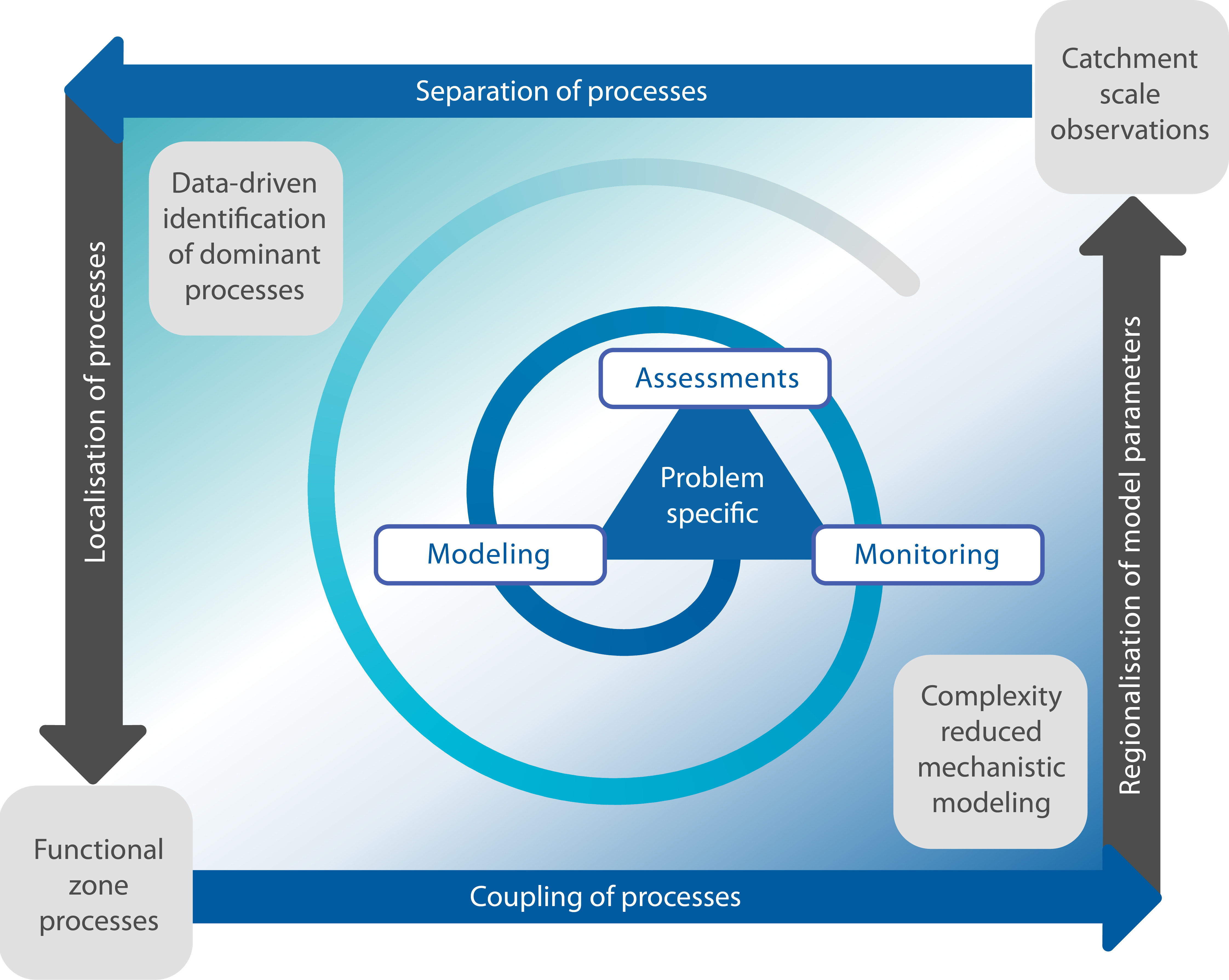
To meet the scientific challenges the IP works in individual projects addressing specific questions and problems. Work in the projects typically follows a general, overarching methodological framework, which combines data-driven integral assessments at larger scales (top-down) with mechanistic process studies at smaller scales (bottom-up) to develop tailored modeling, monitoring and assessment schemes for specific questions and applications (Fig.1). The individual projects usually encompass the entire domain of this framework but may also address more specific aspects within the framework (e.g. dedicated process studies in key functional zones).

