MARZIPAN

Project title: Rezeption der Vegetationszonierung von Mangroven zur simultanen Deduktion der Aquiferstruktur sowie zur Weiterentwicklung von Konzepten der unterirdischen Konkurrenz von Pflanzen bei individuenbasierter Modellierung - MARZIPAN
(Project title – English translation: Adopting mangrove vegetation zonation patterns to gain information on subsurface aquifer structures and advance belowground plant competition concepts in individual-based modelling - MARZIPAN)
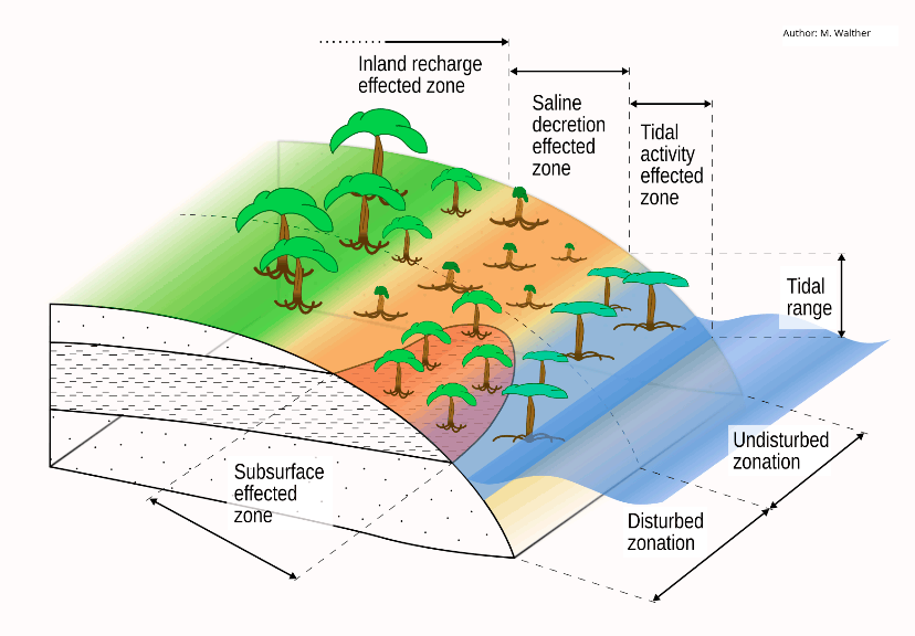
Short project description:With the proposed project, we intend to extend the knowledge and process understanding of the interactions between vegetation and subsurface hydrodynamics by developing and employing a new, fully coupled plant-soil water modelling approach for mangrove ecosystems. Specifically, we want to gain insight into the relationships between (i) visible vegetation patterns like allometry, species composition and zonation and (ii) subsurface aquifer structures and potential gradients by tidal and ground water influence. The fully coupled approach will allow us to benefit equally on both sides: for (i), the new approach will help to understand the physical mechanisms of below-ground plant interaction and open the way for a new plant interaction approach for individual based models considering plant properties and abiotic soil parameters; for (ii), adopting vegetation zonation patterns will enable us to gain information on subsurface aquifer structures and parametrisation.
As a pilot study case we propose the mangrove ecosystem. We hypothesise, that salinity gradients are the obvious link between patterns on the single plant and plant community scale, and - due to their impact on physical properties of the soil water - the hydrodynamic processes in the soil and groundwater matrix. In our approach salinity at the interface between roots and groundwater will on the plant side control water uptake (osmotic potential) and shape plant growth and allometry. Water uptake (osmotic salt exclusion) will increase salinity. Salinity (density gradients) will add to tidal and groundwater gradients as a driver for groundwater flow processes and vice versa temporally and spatially emerge as a boundary condition for plant development. Zonation and its disturbance should thus be attributable to subsurface heterogeneity.
The water potential concepts in the BETTINA plant growth model provide an effective interface to the hydrodynamic processes in the soil matrix which can be described by OpenGeoSys. With this combination, we will be able to reliably predict species distribution and allometric characteristic of plants (tree size, root diameter etc.) from abiotic boundary conditions governed by soil and groundwater flow and transport processes. This will allow us to jointly advance in both, ecological plant community and groundwater modelling: firstly, we will be able to conclude reversely from vegetation parameters as zonation patterns or tree dimensions on domain properties and the heterogeneity of the shallow groundwater system (groundwater view); secondly, we will develop a more sophisticated conceptual competition surrogate approach, which will, in contrast to existing ones like Field of Neighbourhood, take into account characteristics of the abiotic environment or anisotropic conditions.
Project duration: 06/18 – 05/21
Funding organisation: DFG

Project partners:
- Technische Universität Dresden
- University of Queensland, Australia – associated partner
- Nanjing Forestry University, China – associated partner
The research for this project is being conducted in close cooperation with the Chair of Forest System Analysis at the Technische Universität Dresden.
At the Department of Environmental Informatics, research for this project is being conducted at the workgroup Complex Groundwater Systems.
Project website: https://tu-dresden.de/bu/umwelt/hydro/igw/das-institut/mitarbeiter/marc-walther#section-4
This research was also part of the OpenGeoSys initiative (http://www.opengeosys.org/).
