The LUCID model
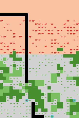
 LUCID land use layer, showing the spatial differentation of land use categories (pastures, enclosures, croplands) and herd location(red/green symbolds).
The Land Use Competition in Drylands (LUCID) model is a joint effort of the Helmholtz Centre for Environmental Research - UFZ and the International Livestock Research Institute (ILRI) to use simulation modeling as a tool for supporting land use planning processes, and to address decision-making around competition among alternative land uses in pastoral and agro-pastoral drylands.
LUCID allows for manipulation of particular parameters and relationships in the model for easy development of alternative scenarios. Currently, the model is a prototype that is still under active development.
We provide here a link to download a version of the model for testing purposes that corresponds to the following ILRI project report released in December 2016 and available for download here:
The LUCID Model and Its Role in Supporting Land Use Planning Processes in Southern Ethiopia
Gunnar Dressler1, Lance W. Robinson2, Birgit Müller1, and Niklas Hase1
1. Helmholtz Centre for Environmental Research - UFZ
2. International Livestock Research Institute
Download the LUCID report (968.3 KB)
For questions, please contact gunnar.dressler@ufz.de or L.Robinson@cgiar.org
Download of the current LUCID model version:
The model has been developed using NetLogo 5.3.1. To test the model, you need to install NetLogo, which is available for free download at https://ccl.northwestern.edu/netlogo/download.shtml.
