CHS Conference Posters
Filter:
e.g. EGU, Attinger, 2014, drought, ...
or by working group: WG-LSH, WG-REP, WG-SSH
or by working group: WG-LSH, WG-REP, WG-SSH
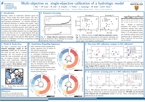
Multi-objective vs. single-objective calibration of a hydrologic model
AGU 2015 Juliane Mai, Matthias Cuntz, Matthias Zink, David Schaefer, Stephan Thober, Luis Samaniego, Mahyar Shafii, and Bryan Tolson (WG-LSH, WG-REP)Abstract:
Hydrologic models are traditionally calibrated against discharge. Recent studies have shown however, that only a few global model parameters are constrained using the integral discharge measurements. It is therefore advisable to use additional information to calibrate those models. Snow pack data, for example, could improve the parametrization of snow-related processes, which might be underrepresented when using only discharge. One common approach is to combine these multiple objectives into one single objective function and allow the use of a single-objective algorithm. Another strategy is to consider the different objectives separately and apply a Pareto-optimizing algorithm. Both methods are challenging in the choice of appropriate multiple objectives with either conflicting interests or the focus on different model processes.
A first aim of this study is to compare the two approaches employing the mesoscale Hydrologic Model mHM at several distinct river basins over Europe and North America. This comparison will allow the identification of the single-objective solution on the Pareto front. It is elucidated if this position is determined by the weighting and scaling of the multiple objectives when combing them to the single objective.
The principal second aim is to guide the selection of proper objectives employing sensitivity analyses. These analyses are used to determine if an additional information would help to constrain additional model parameters. The additional information are either multiple data sources or multiple signatures of one measurement. It is evaluated if specific discharge signatures can inform different parts of the hydrologic model. The results show that an appropriate selection of discharge signatures increased the number of constrained parameters by more than 50\% compared to using only NSE of the discharge time series. It is further assessed if the use of these signatures impose conflicting objectives on the hydrologic model. The usage of signatures is furthermore contrasted to the use of additional observations such as soil moisture or snow height. The gain of using an auxiliary dataset is determined using the parametric sensitivity on the respective modeled variable.
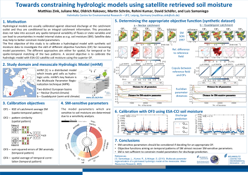
Towards constraining hydrologic models using satellite retrieved soil moisture
AGU 2015 Matthias Zink, Juliane Mai, Martin Schrön, Oldrich Rakovec, David Schäfer, and Luis Samaniego (WG-LSH)Abstract:
Hydrological models are usually calibrated against observed discharge at the catch- ment outlet and thus are conditioned by an integral catchment information. This pro- cedure ensures the fulfillment of the catchment’s water balance but can lead to high predictive uncertainties in model internal states, like soil moisture, or a lack in spatial representativeness of the model. However, some hydrologic applications, as e.g. soil drought monitoring and prediction, rely on this information.
Within this study we propose a framework in which the mesoscale Hydrologic Model (mHM) is calibrated with soil moisture data from various sources. The aim is to con- dition the model on soil moisture (SM), while preserving good performance in discharge estimation. We identify the most appropriate objective functions by conducting synthetic experiments. The best objective function is determined based on i) deviation of synthetic and simulated soil moisture, ii) nonparametric comparison of SM fields (e.g copulas), and iii) by euclidian distance of model parameters. Those objective functions performing best are used to calibrate mHM against satellite soil moisture products (e.g. ESA-CCI) and local in situ observations. This procedure is tested in 3 distinct European basins ranging from snow domination to semi arid climatic conditions.
The results of the synthetic experiment indicate that objective functions focusing on the temporal dynamics of SM are preferable to objective functions aiming on spatial patterns or catchment averages. The best performance in the sense of parameter distance is achieved using temporal correlation or the sum of squared distances from soil moisture anomalies of observed and estimated soil moisture. By comparing the copulas of the different objective functions no significant differences between the methods is observed. Employing satellite data, in a consecutive step, the calibrated model is able to catch soil moisture dynamics but deteriorates the discharge signal.
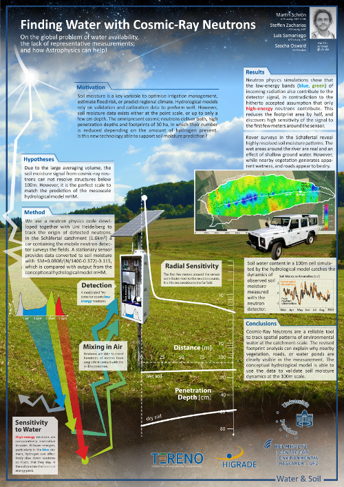
Finding Water with Cosmic-Ray Neutrons
HIGRADE 2015 Martin Schrön, Steffen Zacharias, Luis Samaniego, Sascha Oswald (WG-LSH)Abstract:
Water is not homogeneously distributed in soils and vegetation. Any point measurement would not be representative enough for a field site. And any pixel from satellite remote sensing products is much too coarse and shallow. However, agricultural decisions and regional hydrological models can only be supported with representative data at the hectometer to kilometer scale.
Cosmic-ray neutrons are the solution everyone has waited for: Small particles, that are omnipresent in nature, form a mixed gas in air. Its density depends on the amount of water in the vicinity of several tens of hectares and 0.5m soil depth, because hydrogen is most efficient in slowing and capturing the fast moving neutrons. Together with the UFZ and TERENO we installed several stationary neutron detectors in agricultural fields, forests, urban area and even a lake, to test their performance to monitor temporal water dynamics. Additionally, mobile campaigns have been performed regularly with large detectors in cars and gyrocopters. These surveys catch spatial soil moisture and vegetation patterns to support process understanding for catchment hydrology.
Both, the time serieses and spatial data are used to validate and calibrate the regional hydrological model mHM at the Schäfertal test site (a sub-basin of the Selke). Thereby the model performance to predict soil moisture can be improved and its parameters could "learn" to perform well also in larger, ungauged catchments. Cosmic-ray neutrons are the most promising tool to represenatively observe soil moisture variability at relevant scales. The information is essential for farmers and modelers to reliably predict soil moisture states and their effects to drought conditions and flood risk.
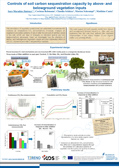
Controls of soil carbon sequestration capacity by above- and belowground vegetation inputs
SOM 2015 Sara Marañón-Jiménez, Claudia Schütze, Corinna Rebmann, Marion Schrumpf, Matthias Cuntz (WG-REP)Abstract:
Vegetation productivity can potentially compensate the increase on atmospheric CO2 concentrations by the
stimulation of photosynthesis. However, the capacity of ecosystems to offset the rise of CO2 in the atmosphere
will depend on nutrient availability and on vegetationsoil microbial interactions. Changes in vegetation
productivity and carbon allocation patterns would alter the detritus inputs to the soil, which can potentially lead
to changes on microbial activity and biogeochemical processes. Specifically, the extra supply of fresh organic
matter both from aboveand belowground detritus inputs (i.e.: litter and root exudates) into the soil may
activate the microbial mineralization of the stable fraction of soil organic matter (i.e.: priming effect). These soil
carbon losses can be especially sensitive to environmental changes such as temperature and moisture. The
magnitude of aboveand belowground inputs is ultimately controlled by C allocation patterns in response to
atmospheric CO2 and soil nutrient availability, however, their relative role and interactions controlling soil C
sequestration capacity has not been specifically assessed before. We hypothesize that: 1) Above and
belowground vegetation interact controlling soil CO2 emissions. 2) The activation of soil organic matter
mineralization by labile organic substrates (i.e.: priming effect) depends on the amount and quality of the
detritus inputs. 3) The higher availability of fresh detritus inputs enhances the soil respiration sensitivity to
temperature.
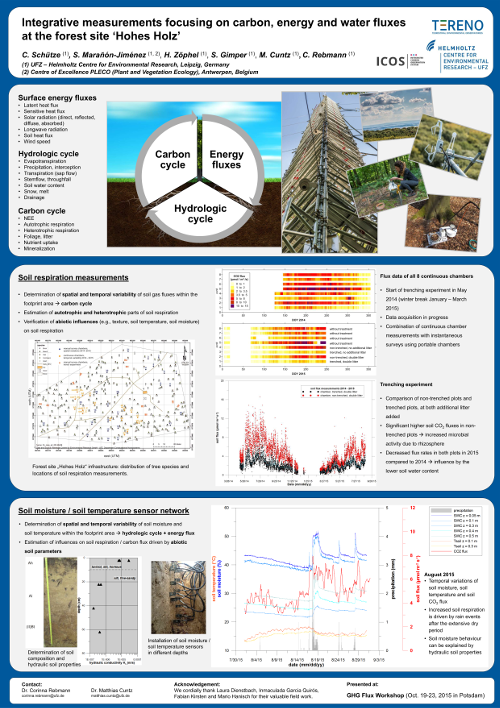
Integrative measurements focusing on carbon, energy and water fluxes at the forest site ‘Hohes Holz’
GHG-Flux 2015 Claudia Schütze, Sara Marañón-Jiménez, Hendrik Zöphel, Sebastian Gimper, Matthias Cuntz, Corinna Rebmann (WG-REP)Abstract:
The reduction of greenhouse gas (GHG) emissions and the optimization of carbon sequestration by ecosystems have become priority objectives for current climate change policies. In this context, the long term research project TERENO and the international research infrastructure ICOS were created. Within these projects different ecosystems are investigated with respect to their energy and matter fluxes under the influence of environmental changes. The eddy covariance technique allows obtaining an integrative estimation of the ecosystem carbon and water balance within the footprint of the tower. Furthermore, the assessment of accompanying parameters in response to environmental variables needs to be accounted with increased resolution to determine the specific heterogeneity of the stand. The investigations of these multiple controlling and interacting mechanisms will help to improve the understanding of the complex processes relevant to the energy, hydrologic and carbon cycles.
Different ecosystems within the same climatic region are under investigation: (I) a forest (Hohes Holz), (II) a grassland (Großes Bruch) and (III) an agricultural site. At the 1500 ha large forest site a comprehensive system of instrumentation provides continuous data for the evaluation of energy, water and carbon exchange of the complex ecosystem including a 50 m high eddy covariance (EC) tower for micrometeorological investigation in different heights above and below canopy, throughfall and stemflow sensors, a soil moisture/temperature sensor network, a soil respiration chamber system, sap flow sensors, and ancillary analysis of trees and understorey vegetation.
Eddy covariance measurements will allow the assessment of the carbon (Net Ecosystem Exchange, NEE) and water balance at the ecosystem scale. In order to achieve higher accuracy in the partitioning between net primary productivity (NPP) and heterotrophic respiration, NEE estimated by eddy covariance needs to be validated with ancillary field measurements. The design and evaluation of global-scale carbon models requires field estimates of NPP and their response to global change and perturbations. Tower-based data of NEE will be therefore complemented and validated with field measurements of C stocks and allocation in biomass and soil, leaf area index estimations, soil respiration measurements (both with continuous measurements and manual survey campaigns) and with the determination of the C emissions from litter and coarse woody debris decomposition. Water flux assessment includes forest floor interception and soil moisture measured in high spatial and temporal resolution using a wireless sensor network.
The Helmholtz Centre for Environmental Research – UFZ is running permanent ecosystem stations above different land use types in the Bode catchment within the foreland of the Harz mountains.
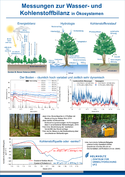
Tower Inauguration 2015 Corinna Rebmann, Matthias Cuntz, Claudia Schütze, Hendrik Zoephel, Sebastian Gimper, Luis Samaniego, Sabine Attinger (WG-LSH, WG-REP, WG-SSH)Abstract:
The Helmholtz Centre for Environmental Research – UFZ is running permanent ecosystem stations above different land use types in the Bode catchment within the foreland of the Harz mountains.
At the field site ‘Hohes Holz’, the energy and trace gas exchange between the ecosystem and the atmosphere is determined with the help of the eddy covariance technique. Therefore a 50m high tower was erected in spring 2014. Since June 2014 measurements in several heights at the tower are running. The variables determined at the tower and close to the soil surface are needed to describe the processes involved in energy and trace gas exchange. Soil respiration, sap flow, soil moisture as well as descriptive determinations of the vegetation characteristics were already performed since 2012. All components that contribute to the carbon and water balance as well as their variability will be investigated in detail for this deciduous forest ecosystem. As such, a soil moisture network is distributed within an area of about 1 ha. Soil respiration is measured at about 25 locations bi-weekly to reflect spatial heterogeneity, continuous measurements are performed at 8 locations (partly treated) to reflect variability in time.
At the field site ‘Hohes Holz’, the energy and trace gas exchange between the ecosystem and the atmosphere is determined with the help of the eddy covariance technique. Therefore a 50m high tower was erected in spring 2014. Since June 2014 measurements in several heights at the tower are running. The variables determined at the tower and close to the soil surface are needed to describe the processes involved in energy and trace gas exchange. Soil respiration, sap flow, soil moisture as well as descriptive determinations of the vegetation characteristics were already performed since 2012. All components that contribute to the carbon and water balance as well as their variability will be investigated in detail for this deciduous forest ecosystem. As such, a soil moisture network is distributed within an area of about 1 ha. Soil respiration is measured at about 25 locations bi-weekly to reflect spatial heterogeneity, continuous measurements are performed at 8 locations (partly treated) to reflect variability in time.
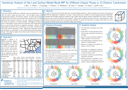
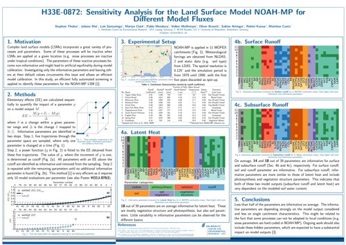
Sensitivity Analysis of the Land Surface Model Noah-MP for Different Output Fluxes in 12 Distinct Catchments
EGU 2015 Juliane Mai, Stephan Thober, Luis Samaniego, Oliver Branch, Volker Wulfmeyer, Martyn Clark, Sabine Attinger, Rohini Kumar, Matthias Cuntz (WG-LSH, WG-REP, WG-SSH)Abstract:
Land Surface Models (LSMs) use a plenitude of process descriptions to represent the carbon, energy and water cycles. They are highly complex and computationally expensive. Practitioners, however, are often only interested in specific parts of the model such as latent heat or surface runoff. In model applications like parameter estimation, the most important parameters are then chosen by experience or expert knowledge. Hydrologists interested in surface runoff therefore chose mostly soil parameters while biogeochemists focus on carbon fluxes and hence on vegetation parameters. However, this might lead to the omission of parameters that are important, for example, through strong interactions with the parameters chosen. It also happens during model development that some process descriptions contain fixed values, which are supposedly unimportant parameters. However, these hidden parameters remain normally undetected although they might be highly relevant during model calibration.
Sensitivity analyses are used to identify informative model parameters for a specific model output. Standard methods for sensitivity analysis such as Sobol indexes require large amounts of model evaluations, specifically in case of many model parameters. We hence propose to first use a recently developed inexpensive sequential screening method based on Elementary Effects that has proven to identify the relevant informative parameters. This reduces the number parameters and therefore model evaluations for subsequent analyses such as sensitivity analysis or model calibration.
In this study, we quantify parametric sensitivities of the land surface model Noah-MP that is a state-of-the-art LSM and used at regional scale as the land surface scheme of the atmospheric Weather Research and Forecasting Model (WRF). NOAH-MP contains multiple process parameterizations yielding a considerable amount of parameters (~100). Sensitivities for the three model outputs (a) surface runoff, (b) underground runoff and (c) latent heat are calculated on twelve Model Parameter Estimation Experiment (MOPEX) catchments ranging in size from 1020 to 4421 km2. This allows investigation of parametric sensitivities for distinct hydro-climatic characteristics, emphasizing different land-surface processes.
The sequential screening identifies the most informative parameters of Noah-MP for different model output variables. The number of parameters is reduced substantially for all of the three model outputs to approximately 25. The subsequent Sobol method quantifies the sensitivities of these informative parameters. The study demonstrates the existence of sensitive, important parameters in almost all parts of the model for the three output variables. This contrasts to the choice of only soil parameters in hydrological studies and only plant parameters when using Eddy covariance data. The sequential screening identified several important hidden parameters that carry large sensitivities and have hence to be included during model calibration.
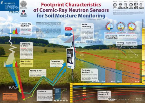
Footprint Characteristics of Cosmic-Ray Neutron Sensors for Soil Moisture Monitoring
EGU 2015 Martin Schrön, Markus Köhli, Marek Zreda, Peter Dietrich, and Steffen Zacharias (WG-LSH)Abstract:
Cosmic-ray neutron sensing is a unique and an increasingly accepted method to monitor the effective soil water
content at the field scale. The technology is famous for its low maintenance, non-invasiveness, continuous
measurement, and most importantly, for its large footprint. Being more representative than point data and finer
resolved than remote-sensing products, cosmic-ray neutron derived soil moisture products provide unrivaled
advantage for mesoscale hydrologic and land surface models.
The method takes advantage of neutrons induced by cosmic radiation which are extraordinarily sensitive to hydrogen and behave like a hot gas. Information about nearby water sources are quickly mixed in a domain of tens of hectares in air. Since experimental determination of the actual spatial extent is hardly possible, scientists have applied numerical models to address the footprint characteristics.
We have revisited previous neutron transport simulations and present a modified conceptual design and refined physical assumptions. Our revised study reveals new insights into probing distance and water sensitivity of detected neutrons under various environmental conditions. These results sharpen the range of interpretation concerning the spatial extent of integral soil moisture products derived from cosmic-ray neutron counts. Our findings will have important impact on calibration strategies, on scales for data assimilation and on the interpolation of soil moisture data derived from mobile cosmic-ray neutron surveys.
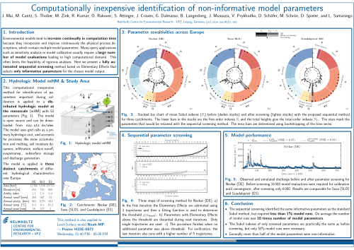
Computationally inexpensive identification of non-informative model parameters
AGU 2014 Juliane Mai, Matthias Cuntz, Stephan Thober, Matthias Zink, Rohini Kumar, Oldrich Rakovec, Sabine Attinger, John Craven, Giovanni Dalmasso, Ben Langenberg, Jude Musuuza, Vladyslav Prykhodko, David Schaefer, Martin Schrön, Diana Spieler, and Luis Samaniego (WG-LSH, WG-REP, WG-SSH)Abstract:
Sensitivity analysis is used, for example, to improve the efficiency of model calibration by discarding insensitive parameters or to detect weaknesses in model formulation and structure. A variety of methods are available for global sensitivity analysis of computational models. They can broadly be divided into derivative-based and variance-based approaches. Derivative-based sensitivity methods highlight key processes for output fluxes and are therefore used to identify major components of a model or detect model weaknesses. Variance-based techniques on the other hand emphasize uncertain processes or process descriptions in the model. Hence, these methods are used to identify parameters which induce the largest variability in the model output and are thus important during calibration. They unfortunately require a large number of model evaluations, but evaluations of complex environmental models are expensive. Therefore, we developed an inexpensive method which applies the Elementary Effects method sequentially and automatically determines informative and non-informative parameters.
This computational inexpensive method for identification of parameters important during calibration is applied to a distributed hydrologic model at the mesoscale (mHM) with 52 parameters. The model is applied in three distinct catchments of different hydrological characteristics over Europe, i.e. Neckar (Germany), Sava (Slovenia), and Guadalquivir (Spain).
The method identifies the same informative parameters as the standard Sobol method but with less than 1% of model runs. In Germany and Slovenia 22 of 52 parameters are informative mostly in the formulations of evapotranspiration, interflow and percolation. In Spain 19 of 52 parameters are informative with an increased importance of soil parameters. The proposed screening method required only 433, 413, and 406 model runs while the standard Sobol method required 75 600, 43 200, and 70 200 in Germany, Slovenia, and Spain, respectively.
We show further that the Sobol indexes calculated only for the subset of informative parameters are practically the same as the Sobol indexes before the screening but the number of model runs is reduced by more than 50%.
The model mHM was then calibrated twice in the three test catchments. First all 52 parameters are taken into account and then only the informative parameters are calibrated while all others are kept fixed at their initial value. In the German catchment the Nash-Sutcliff efficiencies (NSE) were 0.87 and 0.83, in the Slovene basin 0.89 and 0.88, and in the Spanish catchment they were 0.86 and 0.85, respectively.This minor loss of at most 4% in model performance comes along with a substantial decrease of at least 65% in model evaluations, i.e. iterations of the optimization algorithm. The model performs equally well during validation periods in all three catchments, which proves that the proposed method retained all informative model parameters. In summary, we propose an efficient screening method to identify non-informative model parameters that can be discarded during further applications. We have shown that sensitivity analysis keeps its information content even after screening. We could further demonstrate no loss of model performance after screening and subsequent calibration. However, model evaluations could be reduced by at least 50% in both applications.
Sensitivity Analysis for the Land Surface Model NOAH-MP for Different Model Fluxes
AGU 2014 Stephan Thober, Juliane Mai, Luis Samaniego, Martyn Clark, Pablo Mendoza, Volker Wulfmeyer, Oliver Branch, Sabine Attinger, Rohini Kumar, Matthias Cuntz (WG-LSH, WG-REP, WG-SSH)Abstract:
The land-atmosphere fluxes of water, energy and carbon, as computed by the Land Surface Model (LSM), are a critical component of Earth System Models and Numerical Weather Prediction models. Processes and parameters of LSMs are validated mostly against point measurements, for example from Eddy-covariance towers, with much attention given to biophysical processes and vegetation parameters. River discharge on the other hand is not considered very often although it provides an integrated signal of the hydrologic cycle over a catchment. Sensitivity analyses of hydrologic models have shown that soil parameters have then the largest impact on modeled river discharge. In this study, we quantify parametric sensitivities of the land surface model NOAH-MP simultaneously for model outputs at different spatial resolutions. NOAH-MP is a state-of-the-art LSM, which is used at regional scale as the land surface scheme of the atmospheric Weather Research and Forecasting Model (WRF). NOAH-MP contains multiple process parameterizations (hence MP), yielding a considerable amount of parameters (> 500). Standard methods for sensitivity analysis such as Sobol indexes require too many model evaluations in case of many parameters. We therefore use first a recently developed inexpensive screening method based on Elementary Effects that has proven to identify the same informative parameters as the Sobol method but requires only 1% of model evaluations. This reduces the number of parameters to a feasible amount for a thorough sensitivity analysis. The study is conducted on twelve Model Parameter Estimation Experiment (MOPEX) catchments. This allows investigation of parametric sensitivities for distinct hydro-climatic characteristics, emphasizing different land-surface processes. The river basins range in size from 1020 to 4421 km², allowing fast model evaluation. The screening and sensitivity analysis identifies the most informative parameters of NOAH-MP for different model output variables. These parameters can subsequently be used in model calibration and adaptation for better representation of land-atmosphere fluxes at different scales. The long-term objective is to establish flux preservation at multiple resolutions in NOAH-MP to allow assimilation of observations at their representative scale.
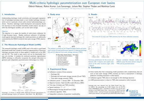
Multi-criteria hydrologic parameterization over European river basins
AGU 2014 Oldrich Rakovec, Rohini Kumar, Luis Samaniego, Juliane Mai, Stephan Thober and Matthias Cuntz (WG-LSH, WG-REP)Abstract:
Understanding hydrologic model uncertainty and meaningful representation of hydrological processes leads to more reliable hydrologic forecasts, which can be in particular critical under extreme hydrometeorologic conditions. Therefore, hydrologic model development and evaluation should not only focus on the simulated streamflow (model output), but also on other key land surface variables. However, scale discrepancy between available observations and modeling resolution is often neglected.
In this study we introduce multiscale and multivariable parameter estimation approach to bridge the scaling gap. The basic components of this framework include the mesoscale hydrologic model (mHM 5.1, http://www.ufz.de/mhm) and the multiscale parameter regionalization (MPR) technique. This framework enables assimilation of various sources of information at their native spatial scales. Additionally, it allows to scrutinize model simultaneously at multiple spatial scales.
The application of this framework is demonstrated over 7 large European basins and evaluated for 350 smaller basins. Besides traditional calibration of hydrologic model against observed discharge, model parametrization is further constrained by a range of other variables available at different spatial scales: GRACE terrestrial water storage content (1° × 1° resolution), eddy flux data (≈500 m footprint) and ESA soil moisture product (0.25° × 0.25° resolution). Initial results shows that model parameterization constrained by streamflow only can not be outperformed. However, while parameterization based on complementary data sets leads to slight deterioration in streamflow performance, this marginal loss is balanced by improved simulation of other model states and fluxes. This becomes beneficial especially during the forecast applications, for which correct model initialization is crucial.
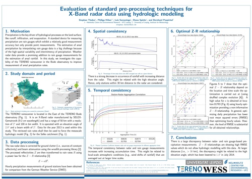
Evaluation of standard pre-processing techniques for X-Band radar data using hydrologic modeling
TERENO 2014 Stephan Thober, Philipp Kilian, Luis Samaniego, Diana Spieler, and Bernhard Pospichal (WG-LSH)Abstract:
Precipitation is the key driver of hydrological processes on the land surface; like runoff, infiltration, and evaporation. A standard device for measuring precipitation are rain gauges which exhibit a relatively good measurement accuracy but only provide point measurements. The estimation of areal precipitation by interpolating rain gauge data is a big challenge because of the high spatial variability and intermittency of precipitation. Weather radar data provide a promising addition to rain gauge measurements for the estimation of areal rainfall. They are able to better resolve the spatial variability of precipitation at the expense of measurement accuracy. In this study, the impact of different precipitation products obtained separately by rain gauge and radar data on hydrologic fluxes like runoff is going to be assessed. The study domain covers the Selke river catchment located in the TERENO Harz observatory. The study period encompasses the calendar year 2013. Hourly rain gauge data is made available by the German Weather Service (DWD), which is interpolated using external drift kriging. The radar data is obtained from the TERENO rain scanner located within the observatory. Raw reflectivity data from this X-Band radar is corrected for ground clutter and attenuation as well as transformed to precipitation rates using standard procedures available from the literature. Both precipitation products are then used to force the mesoscale hydrologic model (mHM) to produce river discharge. It is expected that the precipitation products will generate different streamflow discharges. Preliminary comparisons of the two precipitation products highlight that the discharge produced by the rain gauge interpolation show a closer match than the one obtained from the radar to the observed one. This study provides the first insights on the potential utility of assimilating discharge data to improve radar based precipitation estimates.
Impact of meteorological forcing datasets on regional scale water fluxes and drought characteristics over Germany
EGU 2014 Rohini Kumar, Luis Samaniego, Ben Livneh, Matthias Zink, and David Schäfer (WG-LSH)Abstract:
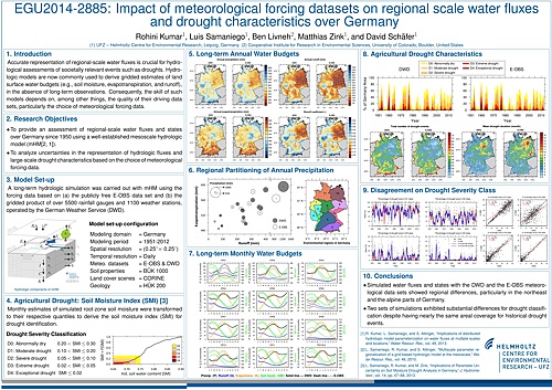
Accurate representation of regional-scale water fluxes is crucial for hydrological assessments of societally relevant events such as droughts. Hydrologic models are now commonly used to derive gridded estimates of land surface water budgets, i.e. soil moisture, runoff, in the absence of long-term observations. Consequently, the skill of such models depends on the quality of their driving data, particularly the choice of meteorological forcing data. In this study, we provide a comprehensive assessment of regional-scale water fluxes and states over Germany since 1950 using a well-established mesoscale hydrologic model (mHM). The goal is to analyze uncertainties in the representation of hydrologic fluxes and large-scale drought characteristics based on the choice of meteorological forcing data. A long-term (1950-2012) country wide hydrological simulation of the land surface water budgets at a 0.25° spatial resolution was carried out with mHM using (a) the publicly free E-OBS data set (v8.0) from the European Climate Assessment & Dataset project and (b) the gridded product based on the relatively dense station network (over 5500 rainfall gauges and 1100 weather stations) operated by the German Weather Service (DWD). These simulations serve to characterize historical agricultural and hydrological drought events based on soil moisture (SMI), and surface runoff (SRI) indices, respectively. Simulated water fluxes and states (e.g., runoff, evapotranspiration, soil moisture) with different meteorological data sets generally showed a high degree of correspondence to each other at annual and seasonal time scales. However, substantial regional differences emerged in the northeast part of Germany (in the Elbe river basin), where the E-OBS-based simulations produced drier conditions than those of the DWD based simulation. Despite similar covariances between both data sets for major historical drought events (1953-54, 1959-60, 1962-65, 1972-74, 1975-78, 1991-93, 1995-97, 2003-05), other drought statistics such as the severity, duration, areal extend, persistence varied substantially, with more severe, persistent E-OBS derived droughts than those using the DWD product. For some interior regions of Germany, differences in drought indices were so great that they failed to identify a common drought event roughly 40 to 60% of the time, with poor agreement (r²= 0.4-0.8) in drought severity classification. These results emphasize the importance of meteorological uncertainty in drought monitoring.
Uncertainty of hydrological forecasts with respect to initial conditions and meteorological forcing for two major flood events in Germany
EGU 2014 Stephan Thober, Andy Wood, Luis Samaniego, Martyn Clark, Rohini Kumar, and Matthias Zink (WG-LSH)Abstract:
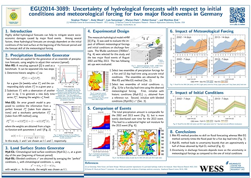
Major flood events are causing severe socio-economic damages. In Germany alone, the havoc wreaked by the 2002 and 2013 floods along the Elbe and Danube river amounted to more than 11 bn EUR. Highly skilled hydrological forecasts can help to mitigate such damages. Among several factors, these hydrological forecasts are strongly dependent on the initial conditions of the land surface at the beginning of the forecast period and the forecast skill of the meteorological forcing. Prior research has investigated how uncertainties of the initial conditions and meteorological forcing impact hydrological forecasts. In these studies, uncertainty is investigated by coupling an ensemble of basin initial conditions (e.g., snow, soil moisture) with an ensemble of meteorological forecasts (e.g., precipitation). However, most previous hydrological predictability studies focus on seasonal forecasts (e.g., forecasts of June-July-August flow volume, initialized on April 1st), and neglect the errors in meteorological forecasts at lead times from 1-14 days. In this study, an error growth model is proposed to investigate hydrological predictability at lead times of 1-14 days. This error growth model calculates a time-dependent weighted average between the perfect forecast and a stochastic perturbation of this. The time-dependent weights are derived from a logistic function. This error growth model thus attributes high weights to the perfect forecast for short lead times (e.g., less than five days) and low weights for longer lead times (e.g., more than five days). For longer lead times, more weight is given to the stochastic perturbation of the forecast and, hence, the ensemble spread is larger for these lead times resembling a higher uncertainty. Analogous to the error growth model, the initial conditions are calculated as a weighted average between the perfect condition and a historic condition of the land surface. The proposed framework is tested in Germany for the 2002 and 2013 flood events along the Elbe and Danube river. The mesoscale Hydrologic Model - mHM is used to evaluate the impact of varying initial conditions and meteorological forcing. The original meteorological data used to generate ensemble forcing is provided by the German Weather Service (DWD). Common metrics such as mean absolute error (MAE) and continuous ranked probability skill scores (CRPSS) are employed to evaluate the forecast skill. Moreover, the elasticity is quantified which is defined as the change in runoff skill per unit change either in forcing or initial condition skill. The analysis helps to understand the relative importance of basin initial conditions and meteorological forecasts for extreme floods in Germany. Results indicate that initial land surface conditions have great impact in hydrological forecast skill for short lead times (e.g., 16.9% chance of reaching actual peak discharge with historic land surface condition). For longer lead times, however, the hydrological forecast skill becomes more dependent on the forecast skill in the meteorological forcing.
Parameterization of PET approaches for distributed hydrologic modeling
EGU 2014 Matthias Zink, Juliane Mai, Luis Samaniego , and Matthias Cuntz (WG-LSH, WG-REP)Abstract:
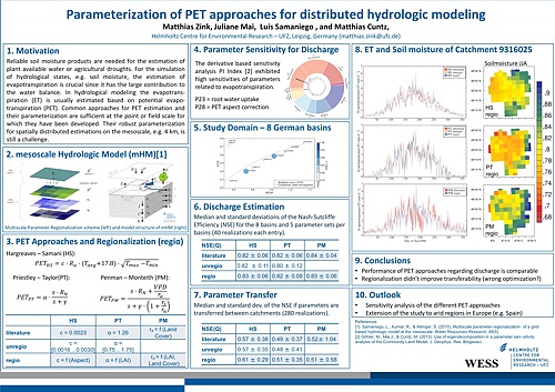
Reliable soil moisture products are needed for the estimation of plant available water or agricultural droughts. For the simulation of hydrological states, e.g. soil moisture, the estimation of evapotranspiration is crucial since it has the largest contribution to the water balance besides precipitation. In hydrological modeling the evapotranspiration is usually estimated based on potential evapotranspiration (PET). The common approaches for PET estimation and their parameterization are sufficient at the point or field scale for which they have been developed. But for spatially distributed estimations on the mesoscale, e.g. 4 km, their robust parameterization is still a challenge in current research. The aim of this study is to find scale and location independent parameters for three different potential evapotranspiration formulations, which are applied in the mesoscale Hydrologic Model (mHM). PET is estimated using the 1) Hargreaves-Samani, 2) Priestley-Taylor, and 3) Penman-Monteith equations. The Hargreaves-Samani method is a temperature driven approach, whereas the other two methods are based on radiation. For estimating the parameters of the above mentioned PET formulations, the Multiscale Parameter Regionalization technique is used. This technique accounts for subgrid variabilities by connecting morphological terrain properties, which are available in a higher resolution than the model resolution, with the parameters for the particular PET approach. The parameters, which needed to be estimated, are the coefficient of the Hargreaves-Samani equation, the Priestley-Taylor coefficient, and the aerodynamic and bulk surface resistance for the Penman-Monteith equation. The Hargreaves-Samani coefficient is regionalized based on the aspect of the terrain. The Priestley-Taylor coefficient as well as the aerodynamic and bulk surface resistance have been estimated using static land cover information combined with leaf area index (LAI) development curves and thus an approximation for vegetation information. This new parameterized PET approaches are evaluated in six different German river basins ranging from 6,000 km2 to 38,000 km2 including a spatial variety from catchments in the northern German lowlands to alpine catchments in the south. The comparison of the results is focusing on evapotranspiration, soil moisture and discharge. Whereas only slight changes in the discharge hydrograph have been observed in the comparison of the three PET equations, the impact on soil moisture is significant. Especially during the summer period the soil moisture is lower for the Priestley-Taylor and Penman-Monteith formulation compared to the Hargreaves-Samani equation. This effect is due to higher estimates in PET for those two methods. Furthermore a validation against eddy covariance measurements showed that the dynamics of evapotranspiration is captured well by the three methods.
The role of temporal disaggregation and land surface initial conditions for hydrological forecasting
AGU 2013 Stephan Thober, Matthias Zink, Rohini Kumar, and Luis Samaniego (WG-LSH)Abstract:
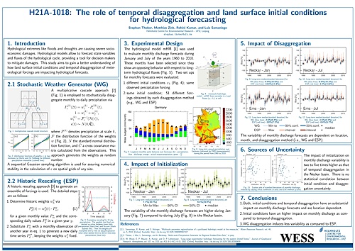
The ability of hydrological forecasts to exhibit a close match with reality is crucial for correctly estimating the extent of natural catastrophes like floods and droughts. The largest part of the uncertainty in hydrological forecasts stems mainly from the highly uncertain states of the meteorological forcings including their spatio-temporal disaggregation and the uncertainty of land surface initial conditions. In this study, we analyze the effects of different temporal disaggregation methods for precipitation downscaling and the role of initial conditions (ICs) on streamflow predictions. The ensemble streamflow prediction system (ESP) is one of the state of the art hydrological prediction methods. Within this framework one of the main assumptions is that the observed past is a valid representative for future conditions. In other words, the forecasted monthly values are temporarily dissaggregated by selecting an observed month and rescaling the daily values such that the forecasted monthly value is preserved. In this study, we provide an alternative stochastic disaggregation (SD) method based on a multiplicative cascade model which preserves the observed spatial structure. We hypothesize that the SD method leads to less uncertain predictions of water fluxes than those obtained by the classical ESP disaggregation. Ensembles of water fluxes and states were generated with both disaggregation schemes using the process based mesoscale hydrological model (mHM) over entire Germany at a spatial resolution of 4x4km2. The ability of these approaches were tested in a hindcast mode for the time period of 1961-2010 and varying ICs. Results obtained with the SD approach showed that this technique is able to preserve the observed precipitation distribution functions as well as its spatio-temporal structure and intermittency. The rescaling step of historical observed values in the classical ESP disaggregation, on the contrary, tends to destroy the spatial structure of observed daily precipitation, which leads to over/underestimation of streamflow forecasts. The proposed SD approach therefore provides a valuable alternative disaggregation scheme to the classical scheme used in the ESP framework. One examplary temporal disaggregation of a 32d timestep via the SD method.
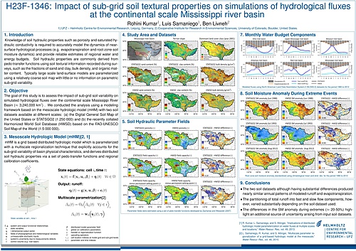
Impact of sub-grid soil textural properties on simulations of hydrological fluxes at the continental scale Mississippi river basin
AGU 2013 Rohini Kumar, Luis Samaniego, Ben Livneh (WG-LSH)Abstract:
Knowledge of soil hydraulic properties such as porosity and saturated hydraulic conductivity is required to accurately model the dynamics of near-surface hydrological processes (e.g. evapotranspiration and root-zone soil moisture dynamics) and provide reliable estimates of regional water and energy budgets. Soil hydraulic properties are commonly derived from pedo-transfer functions using soil textural information recorded during surveys, such as the fractions of sand and clay, bulk density, and organic matter content. Typically large scale land-surface models are parameterized using a relatively coarse soil map with little or no information on parametric sub-grid variability. In this study we analyze the impact of sub-grid soil variability on simulated hydrological fluxes over the Mississippi River Basin (≈3,240,000 km2) at multiple spatio-temporal resolutions. A set of numerical experiments were conducted with the distributed mesoscale hydrologic model (mHM) using two soil datasets: (a) the Digital General Soil Map of the United States or STATSGO2 (1:250 000) and (b) the recently collated Harmonized World Soil Database based on the FAO-UNESCO Soil Map of the World (1:5 000 000). mHM was parameterized with the multi-scale regionalization technique that derives distributed soil hydraulic properties via pedo-transfer functions and regional coefficients. Within the experimental framework, the 3-hourly model simulations were conducted at four spatial resolutions ranging from 0.125° to 1°, using meteorological datasets from the NLDAS-2 project for the time period 1980-2012. Preliminary results indicate that the model was able to capture observed streamflow behavior reasonably well with both soil datasets, in the major sub-basins (i.e. the Missouri, the Upper Mississippi, the Ohio, the Red, and the Arkansas). However, the spatio-temporal patterns of simulated water fluxes and states (e.g. soil moisture, evapotranspiration) from both simulations, showed marked differences; particularly at a shorter time scale (hours to days) in regions with coarse texture sandy soils. Furthermore, the partitioning of total runoff into near-surface interflows and baseflow components was also significantly different between the two simulations. Simulations with the coarser soil map produced comparatively higher baseflows. At longer time scales (months to seasons) where climatic factors plays a major role, the integrated fluxes and states from both sets of model simulations match fairly closely, despite the apparent discrepancy in the partitioning of total runoff.
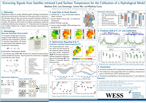
Calibration of a hydrological model using patterns of satellite derived land surface temperature
AGU 2013 Matthias Zink, Luis Samaniego, Juliane Mai, and Matthias Cuntz (WG-LSH, WG-REP)Abstract:
Hydrological models are usually calibrated against discharge and thus rely on gauging station information for estimating hydrological fluxes and state variables within the catchment of interest. But gauging data are rarely available and do only deliver information about spatially integrated signals of water fluxes within a catchment. In contrast, satellite data which include spatial distributed information are broadly available. Since satellite derived soil moisture and evapotranspiration data are prone to large uncertainty, more certain land surface temperature data are used in this study. The objective of this study is to assess the predictive skill of satellite derived land surface temperature Ts regarding discharge by calibrating the distributed hydrological model mHM using Ts. Since mHM was not capable for estimating Ts, an additional module using the energy balance has been developed. By providing net radiation (Rn) as an input, using evapotranspiration (ET) as residual of the water balance and assuming that soil heat flux and storage terms are negligible, the remaining term of the energy balance is sensible heat (H). By rearranging the sensible heat formulation and substituting H with the before mentioned remainder (Rn-ET), Ts can be estimated. Since comparison of ground measurements with satellite Ts shows an inherent bias (~4.1K), classical quantitative distance measures like mean squared error would yield unreliable calibration results. Though, it is assumed that the spatial distribution of Ts is trustworthy. Hence, a non-parametric, local pattern matching technique has been developed and used for the calibration of the model. This methodology has been tested in six different German river basins ranging from 6,000 km2 to 38,000 km2 including a spatial variety from catchments in the northern German lowlands to alpine influenced catchments in the south. The calibration of the six catchments against Ts leads to Nash Sutcliffe efficiencies (NSEs) of the estimated discharge between 0.3 and 0.6 (medians of 20 optimization runs per basin). While high flows are matched satisfactorily, the prediction of low flows is weak. Conducting cross location experiments which means the application of optimal parameter sets of the five catchments within the sixth yield stable NSEs ranging between 0.3 and 0.6. Furthermore, a change of the spatial distribution of ET within the catchments is observed compared to calibration against discharge. For a relatively homogeneous catchment (regarding soils and land cover) in the north of Germany, the spatial variability of ET decreases compared to results of optimization against discharge. Further, model parameters related to ET are better constrained. In summary, the proposed method shows that satellite derived land surface temperature does not only have an impact on the patterns of ET but also has a predictive skill regarding discharge. Hence, if no discharge data are available, this approach can be used to get an estimate of discharge especially when focusing on high flows.
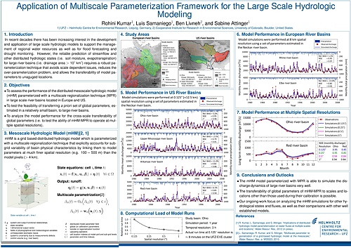
Application of Multiscale Parameterization Framework for the Large Scale Hydrologic Modeling
AGU 2012 Rohini Kumar, Luis Samaniego, Ben Livneh, and Sabine Attinger (WG-LSH, WG-SSH)Abstract:
In recent decades there has been increasing interest in the development and application of large scale hydrologic models to support the management of regional water resources as well as for flood forecasting and drought monitoring. However, the reliable prediction of distributed hydrologic states (i.e. soil moisture, runoff, evapotranspiration) for large river basins (i.e. 100 000 km2) requires a robust parameterization technique that avoids scale dependent issues, reduces the over-parameterization problem, and allows the transferability of model parameters across locations (e.g. to unaguged basins). In this study, we show the ability of the recently developed Multiscale Parameter Regionalization (MPR) technique (Samaniego, et. al. 2010), integrated within a grid based hydrologic model (mHM), to address the above problems. The MPR technique explicitly accounts for sub-grid variability of basin physical characteristics by linking them to model parameters at much finer spatial resolution (e.g. 100–500 m) than the model pixels (> 1 km). The application of the multiscale parameterization framework was tested in four large scale river basins; two in Central Europe (the Rhine and the Elbe river basins), and two in North America (the Ohio and the Red river basins). Model runs were performed at 3h time scale on four spatial resolutions, ranging from a grid size of approximately 7 km to 50 km, for the period from 1960 to 2000. Results of the study indicated that it is possible to transfer a priori set of global parameters, estimated in a relatively small German river basin (Neckar river, 10 000 km2), to all four large river basins including the remote North American basins. The values of Nash Sutcliffe efficiency for the daily and monthly streamflow simulations were, on average, above 0.80. Similar results were obtained from simulations at four spatial resolutions (0.0625°, 0.125°, 0.25°, and 0.5°), which indicated the possibility for the cross-scale transferability of global parameters, without a significant loss of model performance. Further tests were conducted to assess the influence of different precipitation and potential evapotranspiration datasets on simulated hydrologic states and fluxes from mHM, as well as their comparisons with other well established models including those that participated in the second phase of the North-American Land Data Assimilation System (NLDAS-2).
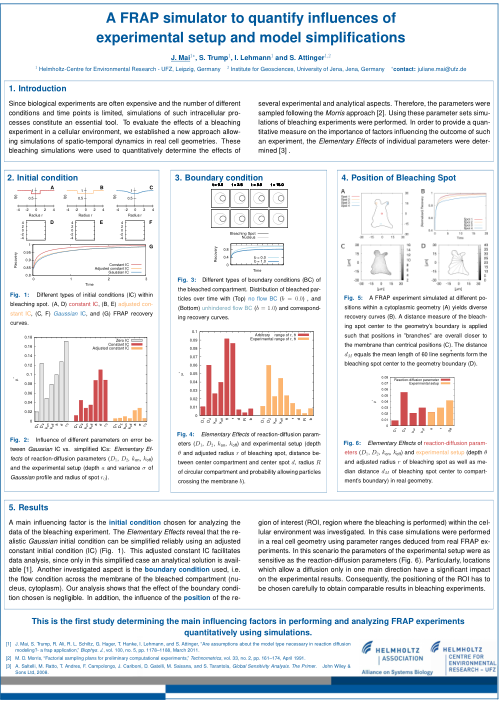
A FRAP simulator to quantify influences of experimental setup and model simplifications
SBHD 2012 Juliane Mai, Saskia Trump, Irina Lehmann and Sabine Attinger (WG-SSH)Abstract:
The interest in molecular interaction and dynamics in living cells is steadily increasing. Several experimental approaches based on fluorescent microscopy have been developed over the years. One of the most widespread techniques to investigate molecular mobility in living cells, is fluorescence recovery after photobleaching (FRAP).
To evaluate the effects of a bleaching experiment in a cellular environment, we established a new approach allowing simulations of spatio-temporal dynamics in real cell geometries. These simulations were used to quanitatively determine the effects of several experimental and analytical aspects.
The computational feasibility of FRAP analysis requires different assumptions which usually not hold in the environment of a living cell. The compartment bleached in a FRAP experiment has a finite extension as opposed to the commonly used hypothesis of infinity.
Another simplification often considered when analyzing FRAP data is complete destruction of all fluorescent particles in the ROI immediately after bleaching. In many cases, this is an oversimplification of the experimental observation. It is easy to imagine that by these model assumptions only approximate model functions describing the time course of the fluorescence recovery within the ROI can be deduced, which will lead to inaccurate parameter values (i.e. diffusion coefficients and reactions rates).
We investigated the quantitative influence of the most commonly used model assumptions (i.e. the initial distribution within the ROI and boundary conditions relating membrane features) as well as the influence of the experimental setup (i.e. the simplification of 3D to 2D processes, the position of the bleaching spot, and the geometry of the bleached compartment).
The results of such an analysis enables a guidance for the experimentalists to use optimal experimental setups as well as to determine the quality of deduced FRAP parameter sets.
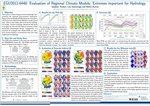
Evaluation of Regional Climate Models: Extremes important for Hydrology
EGU 2012 Stephan Thober, Luis Samaniego and Rohini Kumar (WG-LSH)Abstract:
Well parameterized precipitation-runoff models are often able to reproduce past hydrographs and other state variables quite satisfactorily. In general, extreme events like floods are often linked with heavy rainfall events, persistently long wet spells, rapid temperature increases in winter, among other extreme or rare situations. Getting information to force hydrologic models in future times is not a trivial task. A common approach is to downscale meteorological variables from Regional Climate Models (RCMs) to the desired spatial and temporal resolution required for these models. Therefore, it is crucial that extreme events are well represented in the RCM’s outputs. A significant effort on the evaluation of RCMs has been focused during the past decades to the mean behavior of RCM trajectories and foremost to the identification and correction of model biases. To compare RCMs with each other, it was common to rank them according to their performance. In more recent literature this procedure was enhanced by taking Multi-Model approaches into consideration, where the mean of an ensemble of RCMs is in general better than a single RCM output. Furthermore it has been of interest to evaluate extremes and to correct them. Most studies evaluating RCMs over Europe use either the EObs data set or reanalysis data as reference. In this study, we also investigate the performance of RCMs with respect to extreme statistics relevant for hydrological projections. In addition to quantifying biases of the RCMs, we focus on the evaluation of the spatio-temporal structure of observed extreme statistics given below. Principal Component Analysis (PCA) was used to evaluate the dimensionality of the selected variables and a bootstrapping technique to test the null hypothesis that observed and simulated extreme values come from the same population. To the best of our knowledge, these techniques have not been used in this context. In addition to that, temporal trends and Taylor diagram for all statistics we considered. Reanalysis data from thirteen different RCMs from the ENSEMBLES project covering Germany were chosen for the period from 1961 to 2000. A high resolution data set derived by the interpolation of a dense station network operated by the German Weather Service (DWD) was used as a reference (over 5500 rainfall gauges and 1100 weather stations). This study focuses on extreme variables derived from daily precipitation and temperature, such as 95 percentiles of annual and seasonal total precipitation, 95 percentile of daily temperature, frequency of heavy rainfall, cold and hot days per year. Preliminary results showed that it is very unlikely that the RCM derived statistics and the respective observations are coming from the same populations with a p-values of 1%. PCA, on the contrary, showed that some RCMs are able to represent the overall variability of the observed field in a satisfactory manner (for example for summer and winter total precipitation). A preliminary conclusion of this study indicated that RCM outputs did not preserve the spatio-temporal structure of observed extremes to the level required for operational purposes in hydrological predictions.
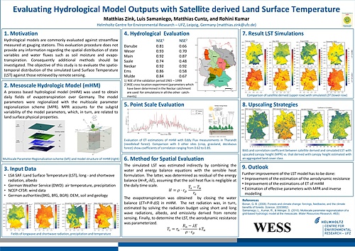
Evaluating Hydrological Model Outputs with Satellite derived Land Surface Temperatur
EGU 2012 Matthias Zink, Luis Samaniego, Matthias Cuntz, and Rohini Kumar (WG-LSH, WG-REP)Abstract:
A combined investigation of the water and energy balance in hydrologic models is needed for a better understanding of exchange, transport, and feedback processes in the soil-vegetation-atmosphere system. These models, however, are often only evaluated at gauging stations. While this evaluation does not provide any information about the spatial distribution of hydrological variables, such as evapotranspiration and soil moisture, additional methods have to be found. The objective of this study is to indirectly evaluate such variables using satellite derived Land Surface Temperature (LST) fields. Therefore, we calculate the Land Surface Temperature with the hydrological model mHM from the sensible heat formulation. The sensible heat is determined as residual of the energy balance, assuming that the soil heat flux and the storage term is negligible at the daily time scale. Additionally, the evapotranspiration is determined due to solving the water balance with mHM. Furthermore, the remaining term of the energy balance, the net radiation, is obtained by solving the radiation budget using long and shortwave incoming radiation, albedo and emissivity data from the Land Surface Analysis - Satellite Application Facility (LSA-SAF, landsaf.meteo.pt). Finally, to determine the LST, the aerodynamic resistance is parameterized to solve the sensible heat formulation. The calculated fields of land surface temperature are evaluated against those provided by LSA-SAF for a period from 2005-2010. The study is carried out in Germany, whereas sets of good performing global transfer parameters are estimated in seven German river basins: Danube, Ems, Main, Mulde, Neckar, Saale and Weser. The average Nash Sutcliffe Efficiencies exceeds 0.7 in the validation period from 2005 to 2010. Preliminary results indicate that the estimated mHM LST agrees quite well with the satellite observations. This result indirectly indicates that the simulated evapotranspiration and corresponding soil moisture fields are reasonable estimates. This assertion will be corroborated by comparison with hourly evapotranspiration fluxes obtained at nine eddy covariance measurement stations (www.fluxdata.org).
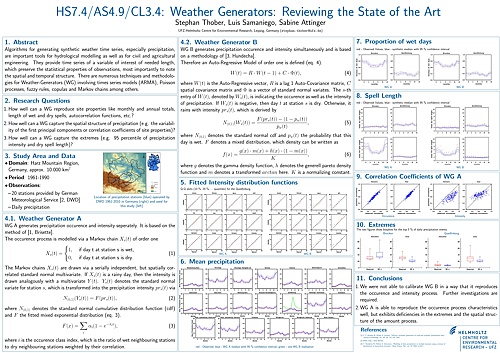
Weather Generators: Reviewing the State of the Art
EGU 2011 Stephan Thober, Luis Samaniego and Sabine Attinger (WG-LSH, WG-SSH)Abstract:
Algorithms for generating synthetic weather time series, especially precipitation and temperature, are important tools for hydrological modelling as well as for civil and agricultural engineering. There is very extensive and rapidly growing literature on the subject. The statistical models that generate this random sequences are called Weather Generators (WGs). Basically there are single- and multi-site WGs. Since the later type is able to capture the spatial and temporal structure of a variable of interest, it has been recently expanded for the downscaling of Global and Regional Climate Models outputs. The range of techniques used in WGs is large: conditional distribution functions of variables of interest, times series models (ARMA), Markov chains, fuzzy rules, copulas, and combinations of them have successfully been used in the past. There are, however, still a number of open questions regarding the efficiency and robustness of WGs that need to be answered if these models should be used for climate change impact analysis. In general we aim to define which are the minimum necessary conditions (i.e. statistical tests) that a WG should pass such that the synthetic and observed time series are statistically indistinguishable regarding their single-site values, their spatio-temporal variability, and their stochastic dependence. A sort of Turing test for WGs. In other words, if there is no perfect WG in a sense that it reproduces all statistical properties that one could ask for, we would like to know which is the expected frontier of a given WG. Specifically, we will consider:
1. How well a WG can reproduce monthly and annual totals, length of wet and dry spells, autocorrelation functions, etc.?
2. How well a WG can capture the spatial structure of the variables of interest (e.g. the joint first principal components of the precipitation and temperature fields)?
3. How well a WG can capture the extremes (e.g. percentile 95 of precipitation intensity and dry spell length)?
Moreover we would like to know how many sites are necessary to estimate the spatio-temporal variability of the variables of interest. At the begin of this study we have implemented two recent multisite-WG proposed by Hundecha et al. (2009, WRR) and Brisette et al. (2007, J. of Hydrol.) for the region within and around the Harz mountains, Germany, comprising the Bode River Basin. The area of the study ares is approximately 40000 km2. For this area 863 rain gauges operated by the German Meteorological Service during the period 1960-2010 are employed. This study is work in progress. Currently the first WG simulating 863 stations lead to singular correlation matrices which, in turn, make the WG inoperative for such large problems. Further reduction to 179 stations (stations that have at least 1800 observations in every decade from 1960-2010) did not improve this situation. We are evaluating various numerical strategies to overcome this issue.
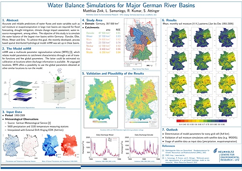
Water Balance Simulations for Major German River Basins
EGU 2011 Matthias Zink, Luis Samaniego, Rohini Kumar, and Sabine Attinger (WG-LSH, WG-SSH)Abstract:
Accurate and reliable predictions of water fluxes and state variables such as soil moisture or evapotranspiration in large river basins are required for flood forecasting, drought mitigation, climate change impact assessment, water resource management, among others. The objective of this study is to simulate the water balance of the five largest rivers within Germany: Danube, Elbe, Rhine, Weser, and Ems. To achieve this goal, the recently developed, process based spatial distributed hydrological model mHM (Samaniego et. al., 2010, WRR) was set up in these basins. mHM uses a multiscale parameter regionalization (MPR) scheme, which relates model parameters to catchment characteristics through a set of transfer functions and few global parameters. The latter could be estimated via calibration at locations where discharge information is available. At ungauged locations, MPR offers a possibility to use the global parameters obtained at other similar locations to run the model. mHM was driven by grided fields of daily meteorological data (e.g. precipitation, temperature), which were interpolated from point measurements using external drift Kriging. Data of 5600 rain gauges and 1100 meteorological stations obtained from German Weather Service (DWD) over Germany during the period from 1950 to 2010 were used for this interpolation. Additional information at a spatial resolution of 100×100 m required to set up mHM comprise a digital elevation model DEM (BKG) and its related characteristics (e.g. slope, aspect, flow direction, flow accumulation), soil properties (BUEK, 1 : 1 000 000), CORINE land cover maps, and hydrological conductivity of geological formations (HUEK, 1 : 1 000 000). Daily stream flow of more than 100 runoff gauging stations were provided by GRDC and EWA. Model simulations were carried out on a spatial resolution of 4×4 km at hourly time steps. The model was calibrated in the period from 1990 to 2000 and evaluated in two periods: 1960-1989 and 2001-2008. Two years of data prior to both periods were set to spin-up the model. Evaluation runs showed a good approximation of the observed daily streamflow. Nash-Sutcliffe efficiencies (NSE) for these river basins varied between 0.7 and 0.9. Monthly and yearly long term water balance were satisfactorily closed. Simulated and observed values exhibited a correlation coefficient larger than 0.9 in all cases. Results of proxy basin tests (i.e. crossvalidation) indicated that mHM is able to reproduce the daily streamflow statistics reasonably well. The least NSE obtained in these tests was 0.5. Currently we are investigating the ability of the model to reproduce extreme runoff characteristics (e.g. magnitude frequency of floods and droughts) and other state variables.
Analysis of spatio-temporal dynamics by FRAP data
ICSB 2011 Juliane Mai, Saskia Trump, Rizwan Ali, Gordon Hager, Thomas Hanke, Irina Lehmann and Sabine Attinger (WG-SSH)Abstract:
Exposure to environmental contaminants can lead to a complex cellular response, including toxic effects that might even be involved in carcinogenesis and immunosuppression. Unraveling the underlying mechanisms is essential not only for a comprehensive understanding of such processes but might help to develop new strategies for therapy and prevention. Since biological experiments are often expensive and the number of different conditions and time points is limited, simulations of such intracellular processes constitute an essential tool. Such simulations not only allow the prediction of a response e.g. at an arbitrary time point, but enable the identification of the primary factors that determine the cellular response to contamination.
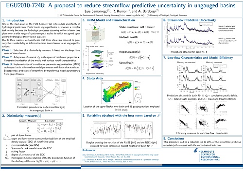
A proposal to reduce streamflow predictive uncertainty in ungauged basins
EGU 2010 Luis Samaniego, Rohini Kumar, and Andras Bardossy (WG-LSH)Abstract:
One of the main goals of the PUB Science Plan is to reduce uncertainty in hydrological predictions. Prediction in ungauged basins is, however, a complex task mainly because the hydrologic processes occurring within a basin take place over a wide range of spatio-temporal scales for which no agreed upon general hydrological theory is still available. For these reasons, various techniques are required to guaranty the transferability of information from donor basins to an ungauged locations. These techniques aim 1) to find an appropriate dissimilarity measure based on discharge time series. 2) to relate a dissimilarity measure with various basin descriptors. 3) to develop a multiscale parameter regionalization (MPR) technique that is able to relate model parameters with basin characteristics through transfers functions and upscaling operators. And, 4) to develop a multi-structure hydrologic model to represent various dominant hydrologic process. As shown in Samaniego et al., 2010a, 2010b, the combination of first three techniques within a Monte Carlo framework have contributed to reduce the predictive uncertainty in a number of crossvalidation experiments in Germany. Additionally, the MPR technique ensures the transferability across modelling scales. In this study, we propose a method that further reduces the streamflow predictive uncertainty at ungauged locations by selecting only those transfer function parameters (from donor basins) which are able to reproduce discharge simulations in an ungauged location whose seasonal runoff characteristics are closer to those obtained with regionalized input-output models (Samaniego and Bárdossy, 2005). Runoff characteristics such as total drought duration, magnitude and frequency of high flows, among others, can be used for this purpose. To illustrate the application of this technique, 34 southern German basins ranging from 70 to 4200 km2 were selected. For each donor basin a number of catchment descriptors were quantified for the regionalization of the runoff characteristics, e.g. mean slope, aspect, shape factor, mean elevation, and several climatic indices such as the antecedent precipitation index and mean monthly temperature. Daily streamflow time series for the donor basins correspond to the period from 1961 to 2000. Results showed that this procedure lead to a reduction up to 20% of the streamflow predictive uncertainty if compared with unconstrained selection of transfer function parameters from the nearest donor basins.
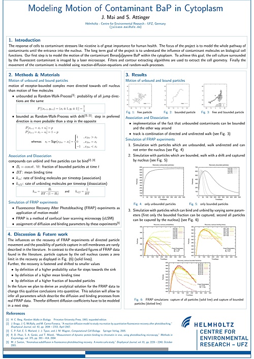
Analysis of spatio-temporal dynamics by FRAP data
JSMC-JCB 2010 Juliane Mai, Saskia Trump, Rizwan Ali, Gordon Hager, Thomas Hanke, Irina Lehmann and Sabine Attinger (WG-SSH)Abstract:
Polycyclic aromatic hydrocarbons (PAHs) are a large group of environmental contaminants. Many of them, such as Benzo[a]pyrene (B[a]P) are carcinogens and are formed as products of incomplete combustion of fossil fuels. Exposure to B[a]P results in rapid uptake, intracellular distribution and binding to the aryl hydrocarbon receptor (AhR).
Within the framework of the systems biology project ”From contaminant molecules to cellular response” we focus on the uptake and distribution of AhR inside cytoplasm and nucleus using Fluorescence Recovery After Photobleaching (FRAP) experiments. We introduce a novel approach for the analysis of FRAP data. By using a (semi-) analytical solution for reaction diffusion equations, allowing for multiple diffusion, we start from the assumption that all involved molecular fractions, whether bound or unbound, could be mobile with different diffusion coefficients. The Laplace transformed equation of the analytical solution is found and inverted numerically using the Stehfest algorithm. For fitting purposes the Simulated Annealing strategy proves to be a better alternative to the conventionally used Levenberg-Marquardt algorithm.
We asses performance of our model by fitting different analytical solutions to artificial FRAP data as well as by applying our approach to FRAP data on yellow protein labelled aryl hydrocarbon receptor (transiently transfected into mouse hepatoma cells) comparing the results to previously introduced models. Subsequently we test the capability of our fitting algorithm for identifying the characteristics of binding and diffusion (i.e. number of binding partners, percentage of bound and unbound fraction, binding and diffusion constants).
Our new approach shows that intracellular molecular mobility can only be described adequately by allowing for multiple diffusion processes which need to be considered when modelling such data.
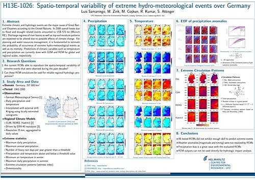
Analysis of the spatio-temporal variability of extreme hydro-meteorological events over Germany
AGU 2010 Luis Samaniego, Mehmet Coskun, Rohini Kumar, Matthias Zink, and Sabine Attinger (WG-LSH, WG-SSH)Abstract:
Extreme hydro-meteorological events are the major cause of Great Natural Disasters according to the United Nations. In 2008 overall losses due to flood and drought related events amounted to US\~570 bn (Munich RE). Discharge regimes of river basins are expected to be altered due to possible effects of climate change. For planning and water resources management, it is fundamental to estimate the probability of occurrence of extreme hydro-meteorological events as well as its intensity. Predictions of climatic variables such as temperature and precipitation are currently done with GCM and RCM for global and regional scales, respectively. A fundamental research question at the moment is: are current RCMs able to reproduce the spatio-temporal variability of extreme events that were observed during the past decades? If not, what kind of bias exist in those data sets and how can these simulations be made useful for hydrologic projections? In this study we analyze these questions using the most recent comprehensive RCM data sets available from the ENSEMBLES project over whole Germany for the period from 1961 to 2000. During this period all RCMs were driven by ERA-40 reanalysis at spatial resolutions of 25 km and 50 km. Among the analyzed variables were the time evolution and the areal extend of various extreme statistics such as precipitation and temperature above and below a threshold value, maximum and minimum air temperatures, maximum daily precipitation in summer. Additionally the spatial correlation structure of daily precipitation and the spatial pattern of a wetness index for each synoptic circulation pattern were also considered. These indices were compared with their respective ones obtained from observations of more than five thousand meteorological stations over Germany. Preliminary results indicate that the various RCMs were able to reproduce in some cases and for some indices the observed spatial patterns. The magnitudes of extreme event indices (Fig. 1) were, however, misrepresented which need to be addressed before these data sets are used for hydrological projections. Bias correction options are still a work in progress and we hope to report some results in due time. Average number of hot days per year (T > 25° C) over the Neckar basin (south Germany)
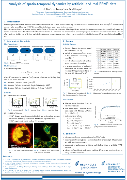
Analysis of spatio-temporal dynamics by artificial and real FRAP data
WCSB 2009 Juliane Mai, Saskia Trump, Rizwan Ali, Gordon Hager, Thomas Hanke, Irina Lehmann and Sabine Attinger (WG-SSH)Abstract:
The response of cells to contaminants is of great importance for human health. The project focus is to model the motion of a contaminants. Therefore, we use the well- known experiment Fluorescence Recovery After Photobleaching FRAP, which enables us to analyse binding and diffusion of fluorescent particles. Already published analytical solutions which describe the FRAP recovery for several cases only deal with diffusion of unbounded particles. First, we derived the laplace transformed solution for diffusion of all particles. Second, we fit different solutions to artificial data and try to identify both the strategy of acting and the parameters of binding and diffusion. Third, to give an example of use we fit the analytical solutions to real FRAP measurements.
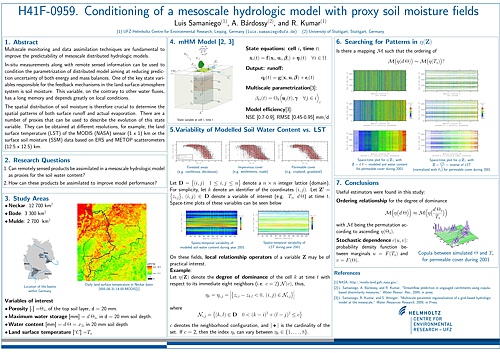
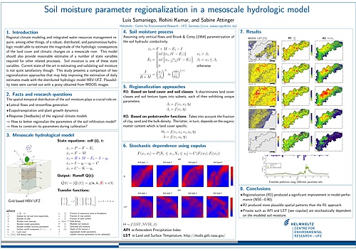
Conditioning of a mesoscale hydrologic model with proxy soil moisture fields
AGU 2009 Luis Samaniego, Andras Bardossy, and Rohini Kumar (WG-LSH)Abstract:
Multiscale monitoring and data assimilation techniques are fundamental to improve the predictability of mesoscale distributed hydrologic models. In-situ measurements along with remote sensed information can be used to condition the parametrization of distributed models aiming at reducing their prediction uncertainty of both energy and mass balances. One of the key state variables responsible for the feedback mechanisms in the land-surface-atmosphere system is the soil moisture. This variable, on the contrary to other water fluxes, has a long memory and depends greatly on local conditions. The spatial distribution of soil moisture is therefore crucial to determine the spatial patterns of both surface runoff and actual evaporation. There are a number of proxies that can be used to describe the evolution of this state variable. They can be obtained at different resolutions, for example, the land surface temperature of the MODIS (NASA) sensor (1 x 1) km or the surface soil moisture (SSM) data based on ERS and METOP scatterometers (12.5 x 12.5) km. In this study we develop local-neighborhood estimators that help to constrain the spatio-temporal evolution of the top-layer soil moisture during a period of time. These estimators are included in the calibration process as a penalty function. The mesoscale hydrologic model (mHM) employed in this study is forced with (1 x 1) km daily meteorological variables such as precipitation, temperature and potential evapotranspiration. All parameters of mHM were regionalized with a multi-scale parametrization technique. The model was set up in the Neckar Basin in south Germany for the period 2001 to 2007, from which the first four years were used for calibration. The spin up period of the model was from 1992 to 2001. The search of good parameter sets was carried out with simulated annealing. Multiscale conditioning of soil moisture states in addition to the commonly used streamflow data lead to a significant reduction of the variability range of the model outputs (e.g. discharge) as well as that of the calibrated global parameters. The transferability of these parameters to ungauged locations and different scales lead to an improvement in performance of at least 10% compared with those results obtained with a control experiment (i.e. parameters not conditioned with proxy soil moisture fields).
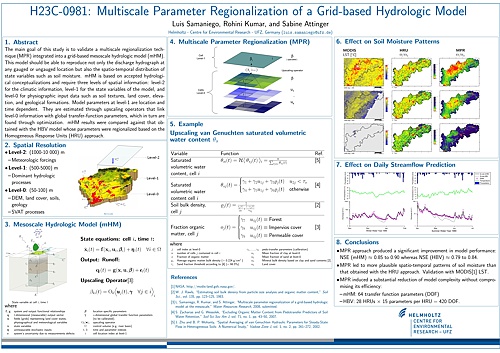
Multiscale Parameter Regionalization of a Grid-based Hydrologic Model
AGU 2008 Luis Samaniego, Rohini Kumar, and Sabine Attinger (WG-LSH, WG-SSH)Abstract:
Integrated water resources planning and management at the mesoscale requires, among other things of a parsimonious and distributed hydrologic model able to reproduce not only the discharge hydrograph at any gauged or ungauged location but also the spatio-temporal distribution of state variables such as soil moisture. Furthermore, this model should be able to take into account changes in land cover and climate as well as management practices. The state-of-the-art with respect to these issues, however, is not yet satisfactory. More specifically, existing models suffer from overparametrization; the lack of an effective technique to integrate the spatial heterogeneity of soils, vegetation, and topography; the non-transferability of model parameters to ungauged basins; and a considerably large execution time. The main goal of this study is to present and validate a multiscale regionalization technique integrated into a grid-based mesoscale hydrologic model (mHM) aiming to address these issues simultaneously. mHM is based on accepted hydrological conceptualizations and require three levels of spatial information: level-2 for the climatic information, level-1 for the state variables of the model, and level-0 for physiographic input data such as soil textures, land cover, elevation, and geological formations. Their spatial resolution varies from (1000-5000)m, (500-1000)m, and (50-100)m respectively. Model parameters at level-1 are location and time dependent. They are estimated through upscaling operators that link level-0 information with global transfer-function parameters, which in turn are found through optimization. The functional relationships constituting these operators are based on process understanding or empirical evidence. Results obtained for 34 basins located in Germany indicated that this regionalization technique contributed not only to reduce significatively the number of free parameters but also to ensure their transferability to ungauged basins. The Nash-Sutcliffe Efficiency (NSE) of mHM was on average 6% greater than that obtained with the standard HBV model but required 85% less effective parameters to calibrate. The HBV model was regionalized with the standard homogeneous response unit (HRU) concept. Moreover, uncertainty and leave-on-out crossvalidation tests showed that this technique produced acceptable streamflow predictions in target basins which were assumed ungauged during crossvalidation. The NSE in the calibration and crossvalidation phases ranged between 0.70 to 0.85 and between 0.55 to 0.75 respectively. Additionally, soil moisture patterns compared well against proxies derived from daily MODIS images (NASA).
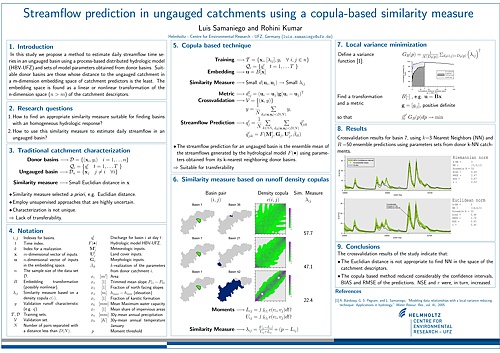
Streamflow prediction in ungauged catchments using a copula-based similarity measure
EGU 2008 Luis Samaniego, and Rohini Kumar (WG-LSH)Abstract:
In this paper we propose a method to estimate daily streamflow time series in an ungauged basin using a process-based distributed hydrologic model (HBV-UFZ) and sets of model parameters obtained from donor basins. Suitable donor basins are those whose distance to the ungauged catchment in a m-dimension embedding space is the least. The embedding space is found as a linear or nonlinear transformation of the n-dimension space (n > m) of the catchment descriptors. The main condition for the embedding space is that a small distance between a given pair of basins implies a similar hydrological response. To guarantee that this condition is always true, the parameters required to define this embedding space are obtained with a local variance minimisation technique using a similarity measure derived from runoff copulas of all pairs of donor basins. The copula-based similarity measure is estimated based on the upper- and lower-tail moments of a runoff copula which denote mainly the climatic and morphologic similarities respectively. It should be emphasised that the scale invariance property of a copula is quite advantageous for defining a similarity measure. The streamflow prediction for an ungauged basin is the ensemble mean of the streamflows generated by the hydrological model using parameters obtained from its k-nearest neighbouring donor basins. Such features constitute the main differences of this technique with respect to other standard procedures reported in the literature in which the similarity measure and the distance is always determined in the original space of the predictors, which not necessarily fulfill the condition mentioned above.
To illustrate the application of this technique, 34 southern German basins rangingfrom 70 to 4200 km 2 were selected. For each basin a number of catchment descriptors were quantified, e.g. mean slope, aspect, shape factor, mean elevation, and several climatic indices such as the antecedent precipitation index and mean monthly temperature. Daily streamflow time series correspond to the period from 1961 to 2000. The hydrologic model used regionalized parameters whose nonlinear transfer function parameters were calibrated with adaptive simulated annealing.
The results were validated with Jackknife crossvalidation against daily discharge observations. Nash-Sutcliffe efficiencies in the calibration and validation phases ranged between 0.70 to 0.85 and between 0.55 to 0.75 respectively. Uncertainty and crossvalidation analyses showed that the proposed technique produced reasonable results for ungauged basins.
Soil moisture parameter regionalization for a mesoscale hydrologic model
EGU 2008 Luis Samaniego, Rohini Kumar, and Sabine Attinger (WG-LSH, WG-SSH)Abstract:
Soil moisture is a key state variable in regional climate, hydrologic, and dynamic vegetation models. It is well recognised that the spatio-temporal distribution of soil moisture plays a crucial role not only on streamflow generation but also on many land-surface-atmosphere interactions on the mesoscale such as evapotranspiration during drying seasons, seasonal precipitation variability among others. Several regionalization and modelling approaches have been proposed in the literature, however, the state-of-the-art is not satisfactory in many aspects. Due to these reasons, this study focus on regionalization approaches for the soil moisture parameters of the hydrologic model (HBV-UFZ) and validation of the spatial patterns of soil moisture. The HBV-UFZ hydrologic model is a spatially explicit, process-based mesoscale model driven by 6-12 h meteorological forcings (e.g. precipitation, temperature, and PET grids) and annual land cover grids. The size of the model grids vary from 100 m to 1000 m depending on the catchment size. This hydrologic model uses regionalized parameters whose nonlinear transfer function parameters are calibrated with multi objective adaptive simulated annealing. Specifically, soil moisture parameters are regionalized with combinations of basin descriptors such as slope, aspect, topographic wetness index, field capacity, porosity, and land cover. To illustrate the application of the regionalization approaches, two southern German basins with an area of 120 to 4200 km 2 respectively are selected. This model is calibrated during the period from 1981 to 1990 and validated subsequently from 1991 to 2002. The validation results (e.g. Nash-Sutcliffe efficiency between 0.70-0.85) indicate that the model with regionalized parameters not only is able to reproduce dom-inant hydrologic processes (e.g. drought spells) but it is also able to reproduce reasonably well the spatial patterns of soil moisture. These patterns compare well against proxies derived from daily MODIS images (NASA) and antecedent precipitation index (API). Conditional spatial copulas between land surface temperature (LST) and modelled soil moisture (SM) indicate a strong inverse stochastic dependence, whereas the copulas between API and SM indicate a strong positive dependence, as expected.
Modeling Motion of Contaminant BaP in Cytoplasm
WCSB 2008 Juliane Mai and Sabine Attinger (WG-SSH)Abstract:
The response of cells to contaminant stressors like nicotine is of great importance for human health. The focus of the project is to model the way of the contaminant until the entrance of the nucleus. Therefore, in the first step the cell culture surrounded by the fluorescent contaminant is imaged by a laser microscope. Filters and contour extracting algorithms are used to extract the cell geometry. Finally the movement of the contaminant is modeled using reaction-diffusion-equations and random-walk-processes. The long term goal of the project is to understand the influence of contaminant molecules on biological cell functions.
Adaptive Parameter Optimization of a Grid-based Conceptual Hydrological Model
AGU 2007 Luis Samaniego, Rohini Kumar, and Sabine Attinger (WG-LSH, WG-SSH)Abstract:
Any spatially explicit hydrological model at the mesoscale is a conceptual approximation of the hydrological cycle and its dominant process occurring at this scale. Manual-expert calibration of this type of models may become quite tedious---if not impossible---taking into account the enormous amount of data required by these kind of models and the intrinsic uncertainty of both the data (input-output) and the model structure. Additionally, the model should be able to reproduce well several process which are accounted by a number of predefined objectives. As a consequence, some degree of automatic calibration would be required to find "good" solutions, each one constituting a trade-off among all calibration criteria. In other words, it is very likely that a number of parameter sets fulfil the optimization criteria and thus can be considered a model solution. In this study, we dealt with two research questions: 1) How to assess the adequate level of model complexity so that model overparameterization is avoided? And, 2) How to find a good solution with a relatively low computational burden? In the present study, a grid-based conceptual hydrological model denoted as HBV-UFZ based on some of the original HBV concepts was employed. This model was driven by 12~h precipitation, temperature, and PET grids which are acquired either from satellite products or from data of meteorological stations. In the latter case, the data was interpolated with external drift Kriging. The first research question was addressed in this study with the implementation of nonlinear transfer functions that regionalize most model parameters as a function of other spatially distributed observables such as land cover (time dependent) and other time independent basin characteristics such as soil type, slope, aspect, geological formations among others. The second question was addressed with an adaptive constrained optimization algorithm based on a parallel implementation of simulated annealing (SA). The main difference with the standard SA is the parameter search routine which uses adaptive heuristic rules to improve its efficiency. These rules are based on the relative behavior of the efficiency criteria. The efficiency of the model is evaluated with the Nash-Sutcliffe efficiency coefficient (NS) and the RMSE obtained for various short and long term runoff characteristics such as daily flows; semiannual high and low flow characteristics such as total drought duration frequency of high flows; and annual specific discharge at various gauging stations. Additionally, the parameter search was constrained with the 95% confidence bands of the runoff characteristics mentioned above. The proposed method was calibrated in the Upper Neckar River basin covering an area of approximately 4000~km2 during the period from 1961 to 1993. The spatial and temporal resolutions used were a grid size of (1000 × 1000)~m and 12~h intervals respectively. The results of the study indicate significant improvement in model performance (e.g. Nash-Sutcliffe of various runoff characteristics ~ 0.8) and a significant reduction in computational burden of at least 25%.
Finding an Appropriate Similarity Measure for Catchment Characterization
AGU 2006 Luis Samaniego, Andras Bardossy and Karsten Schulz (WG-LSH)Abstract:
A vast number of commonly used Euclidian and non-Euclidian similarity measures has been applied in a range of hydrological studies during the last decades, especially for catchment characterization and flood frequency analysis. All these studies have one common feature: the selection of the metric is a priori. In this paper, on the contrary, we propose a general procedure to find an adaptive metric that combines a local variance reducing technique and a linear (or non-linear) embedding of the observation space into an appropriate Euclidean space. To illustrate the application of this technique, several catchments in the German states of Banden-Württemberg and Saxony are presented. Each catchment is characterized by a number of morphologic (e.g. area, slope, aspect), climatic, land cover, and runoff characteristics. The climatic and hydrological characteristics we used include: the antecedent precipitation index, the areal precipitation, the spatial variance of the precipitation, wetness and dryness indexes based on circulation patterns, the change in discharge for a given day, the specific peak discharge, the total drought duration, and the cumulative specific deficit. The results of this study suggest that the quality of the classification using the proposed procedure is improved substantially compared with standard approaches. Uncertainty and crossvalidation analyses suggest that the proposed technique may be appropriate in the case of ungauged catchments.
A Generalization of the Local Estimator Technique
AGU 2005 Luis Samaniego and Andras Bardossy (WG-LSH)Abstract:
Nearest neighbor techniques are commonly used in cluster analysis and statistics either to classify objects into a predefined number of categories or to assess the value of a predictand based on a given set of characteristics or predictors. These techniques are specially useful if the relationship between the variables is highly nonlinear. In most studies, however, the distance measure is adopted a priori and applied to the whole set of observations. In this paper, on the contrary, a general procedure to find an adaptive metric that combines a local variance reducing technique and a linear embedding of the observation space into an appropriate Euclidean space is proposed. In order to illustrate the application of this technique, three applications are presented. The first one deals with the prediction of local discharge characteristics from catchment properties, the second addresses a land cover classification using the LANDSAT bands as predictors, and the third deals with a simple one day flood forecasting problem. The results of the study suggest that the goodness of the fit can be improved substantially.

