Daniel Doktor, Dr.

Head of working group
Helmholtz Centre for Environmental Research - UFZ
Department Remote Sensing
Permoserstrasse 15, 04318 Leipzig - Germany
Tel.: +49 (0) 341 / 6025 1943
Daniel Doktor
Profile
- Within the context of analysing the impacts of climate and global change on vegetation my research focus is on the derivation vegetation dynamics and land-use / land-cover
- Leading of several third party funded projects (BMWI, BfN, EU)
- Collaboration in UFZ strategic processes, e.g. establishment of a Centre for Remote Sensing in cooperation with the University Leipzig
Remotely sensed temporal changes of terrestrial ecosystems are induced by numerous factors. These can be changing temperature and precipitation patterns which potentially affect bio-physical plant composition and subsequently also productivity: feedbacks between ecosystems and biotic factors. However, similar changes can also be introduced by anthropogenic factors such as a modified land-use intensity or effects of land degradation and land-use change. Therefore, the core of my research is at identifying and discriminating the above factors using remotely sensed data. New satellite generation also facilitate the derivation of land-use intensity.
Another aspect of my research is the integration of remotely sensed data into ecosystem models and combining ecosystem modelling with remote sensing studies.Consequently my research focusses on the following aspects:
- Analysis and modelling of vegetation dynamics/phenology at a regional to continental level
- Derivation of bio-physical vegetation parameters => Essential Climate Variables and Essential Biodiversity Variables, e.g. plant productivity
- Land-use classification at plot level / land-use change / land-use intensity (forest, agriculture), regional to national scale
- Methods: Radiative Transfer Modelling + Machine learning method for inverse parameterisation and the analysis of highly dimensional and auto-correlated data
- Prosessing remotely sensed raw data
Education
- 1994 Abitur, Martin-Luther-Schule, Marburg
- 1996-2002 Studies of Geography at the Westfälische Wilhelms Universität Münster, Diplom
- 1998-1999 Studies of Geography at the Universität Rouen, France
- 2003-2007 PhD at Imperial College, London
Non-academic
- 1994-1995 Civil Service, Universitätsklinikum Marburg
Academic posts
- since 2008 Postdoc at the Helmholtz Centre for Environmental Research - UFZ, Leader of the group 'Land-Cover & Dynamics' (LACY)'
- 2007-2008 Research Associate, Imperial College London, Falklands Group
- 2003-2007 PhD, Imperial College (London, U.K.), Department of Biology: Using satellite imagery and ground observations to quantify the effect of intra-annually changing temperature patterns on spring time phenology. Project: 'Time Geographical approaches to Emergence and Sustainable Societies' (TiGrESS)
- 2002-2003 Research Associate, Potsdam Institute of Climate Impact Research (PIK); Projects: 'Sensitivity and Adaptation of Forests under Global Change' (SAFE) and 'Climate Change Adaptility of Wine' (CLAWINE)
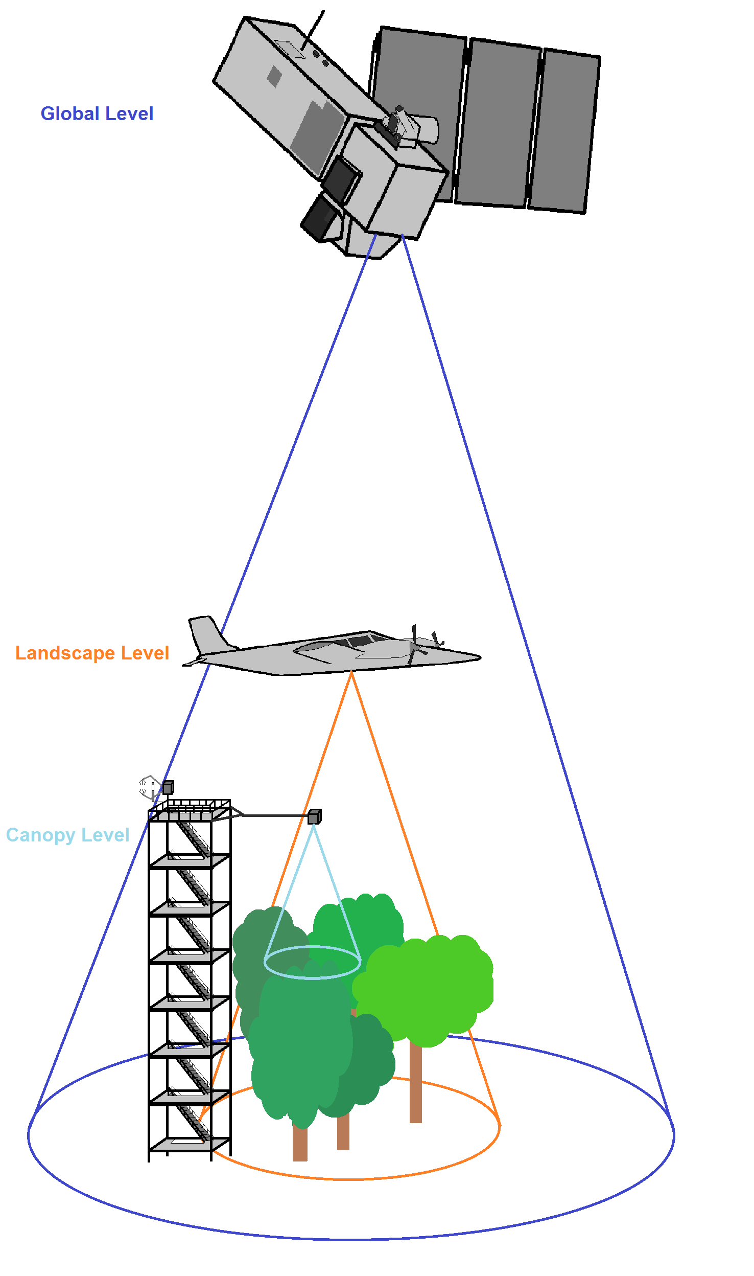
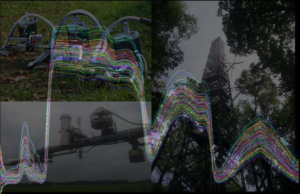
New developments strengthen the link between modelling and remote sensing and sensor fusion, e.g. Helmholtz Alliance ‘Earth System Dynamics’ (http://hgf-eda.de/). Furthermore, large-scale validation sites for remote sensing products including spectral sensor networks are being establishment (Sentinel Missions, ACROSS, GCEF). Data are gathered at different spatial scales covering also micro-meteorological, biological and hydrological aspects (EnMAP project) to facilitate up-scaling (s. Figures below).
Extracting & simulating phenological metrics
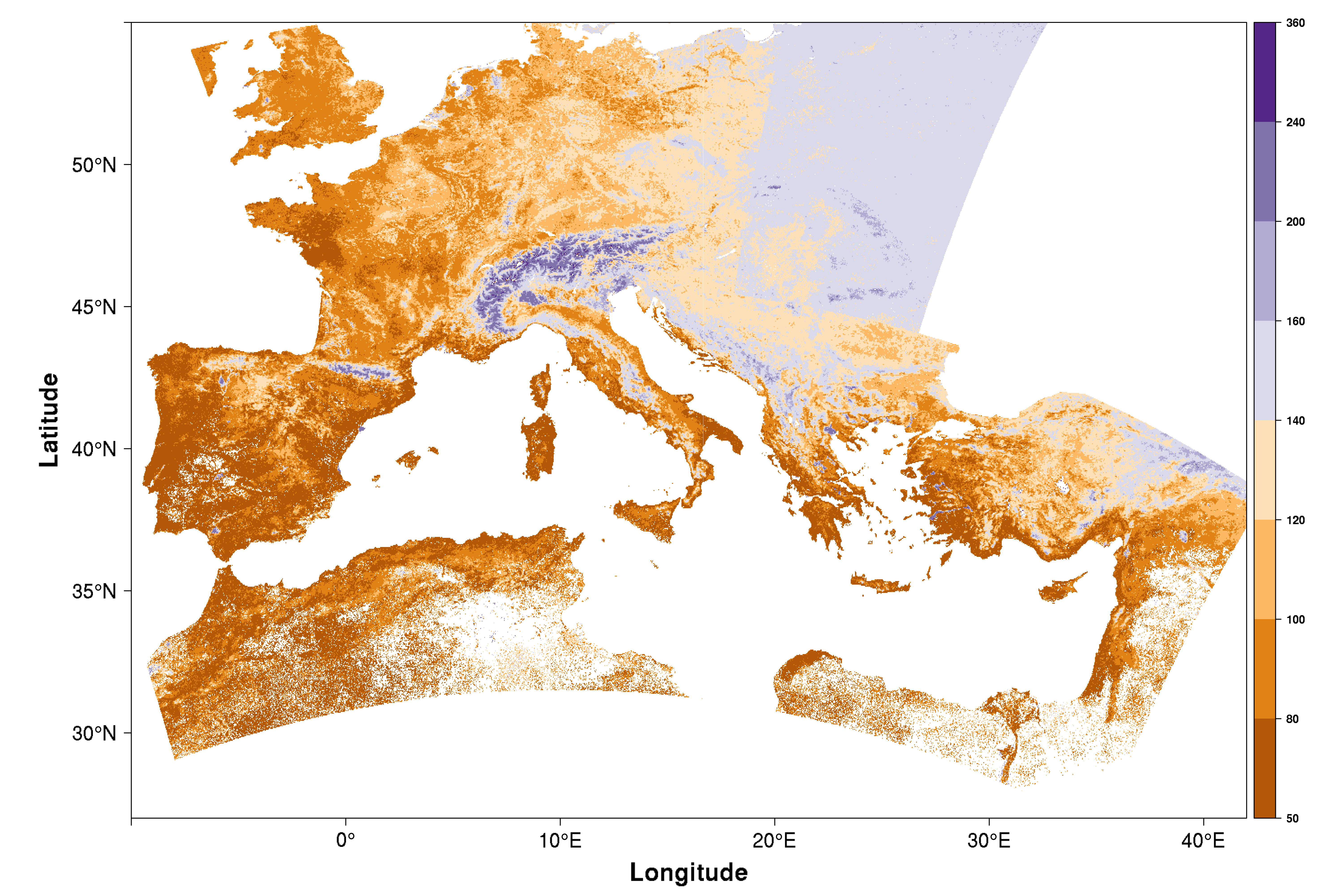
The focus within vegetation phenology is on analysing the response of spring time phenology to climate change using ground and satellite observations. We also assessed the influence of heterogeneous landscapes on computed green-up dates and analysed trends of computed green-up dates on a European scale. A variety of methods to extract phenological metrics has been implemented in R package ’phenex’ to be of public use.
Physical-based phenological modelling
Coupling remote sensing with ecosystem modelling faclitates a better understanding of how bio-physical processes on the earth's surface translate into an electromagnetic signal received by e.g. a satellite sensor. Here, we employ a model driven by temperature and day length (PIM) to simulate phenological growth stages of tree species.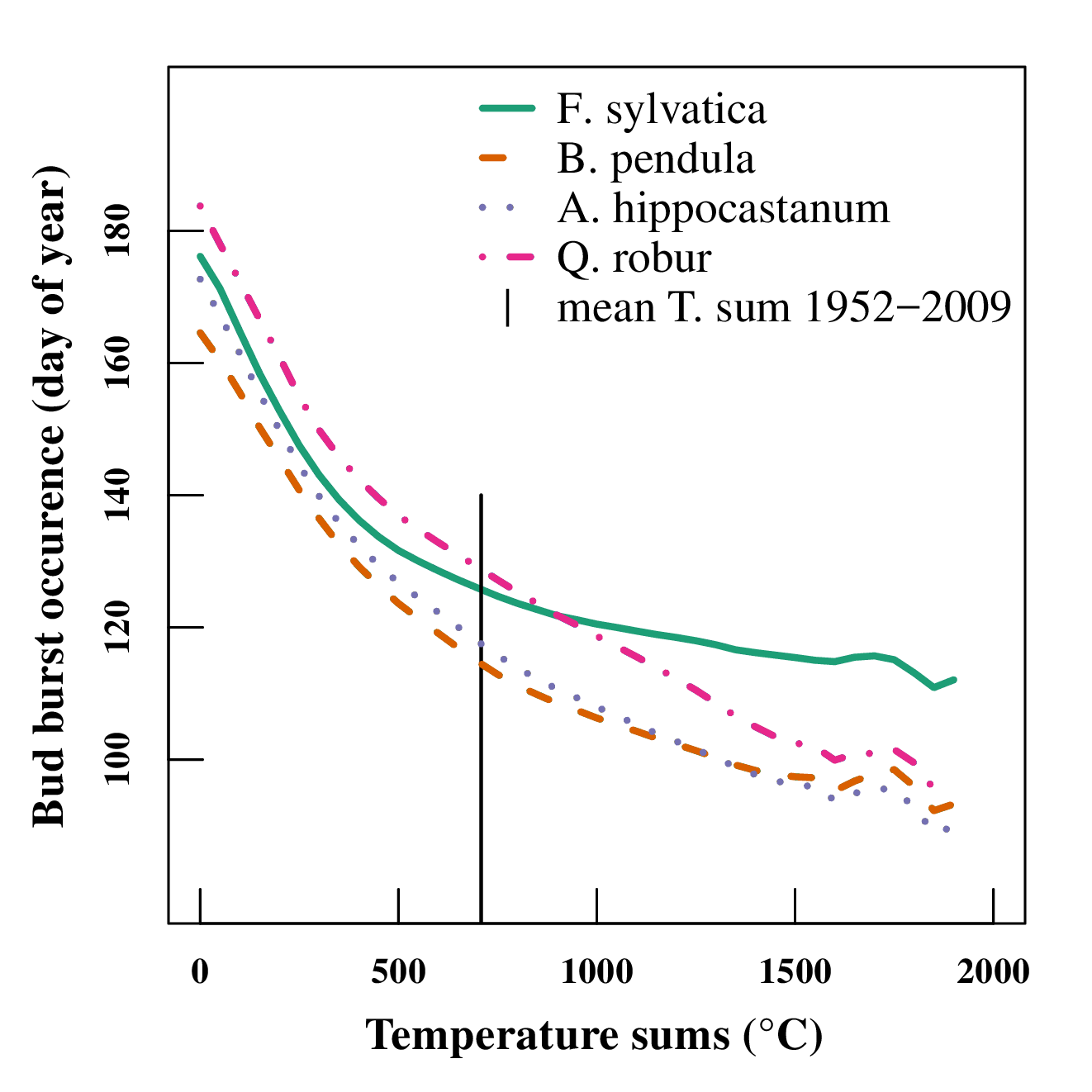
In: Lange, M., Schaber, J., Marx, A., Jäckel, G., Badeck, F.W., Seppelt, R., Doktor, D. (2016). Simulation of forest tree species' phenological phases for different climate scenarios: chilling requirements and photo-period may limit bud burst advancement". International Journal of Biometeorology. DOI 10.1007/s00484-016-1161-8
Extraction of biopyhsical vegetation variables
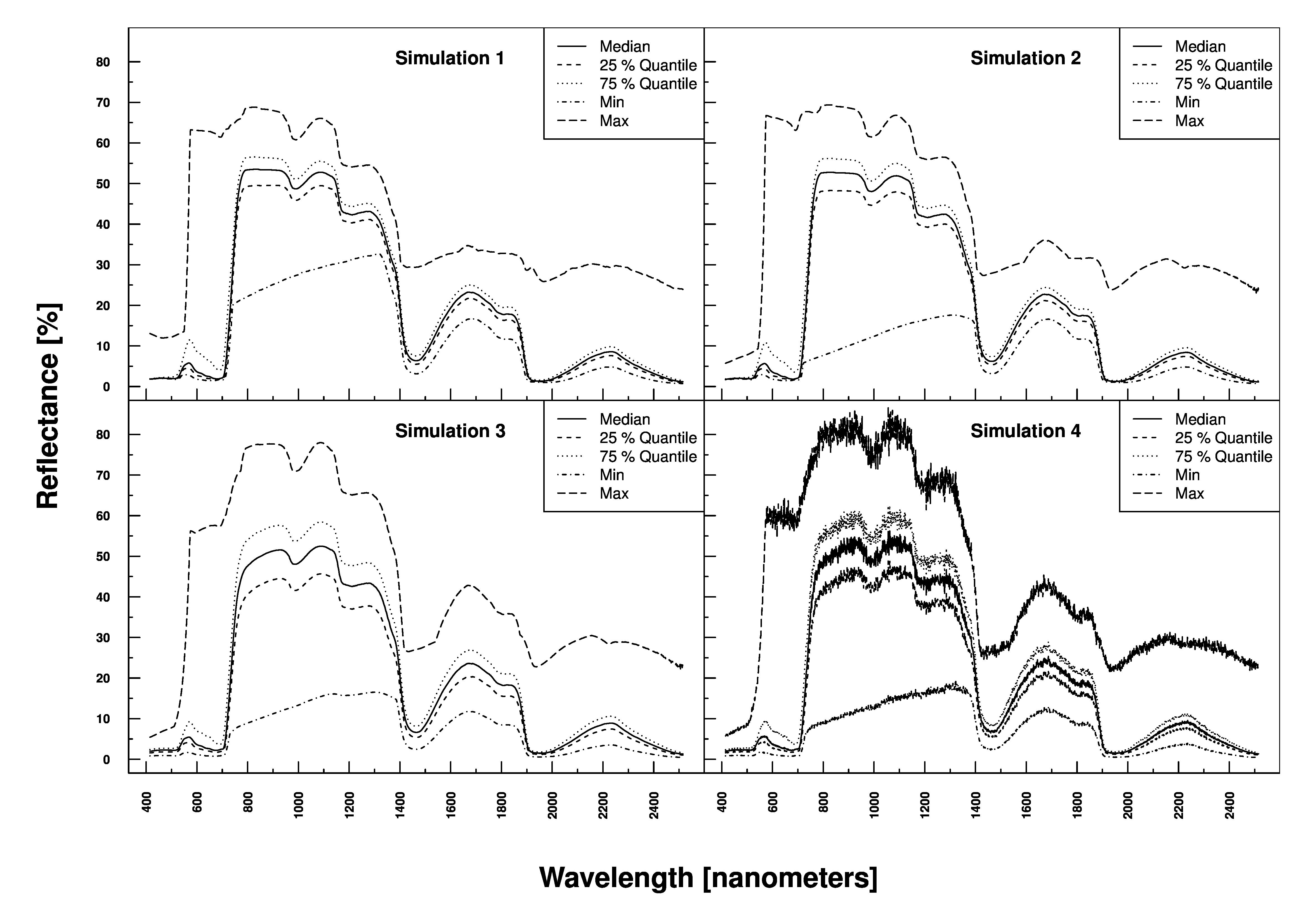
The inversion of radiative transfer models is at the heart of determining e.g. Chlorophyll or water content of vegetation. The figure below shows simulated reflection profiles of vegetation based on 4 parameters sets with increasing complexity (+ noise) using PROSAIL.
Radiative Transfer Modelling
The working group is also simulating at-sensor radiances by combining two models: the vegetation radiative transfer model SLC and the atmosphere radiative transfer model MODTRAN. This allows to work with signals received directly at the sensor, which makes it easier to identify vegetation parameters. Furthermore, this procedure reduces the number of variables for inversion and the overall computational effort required.
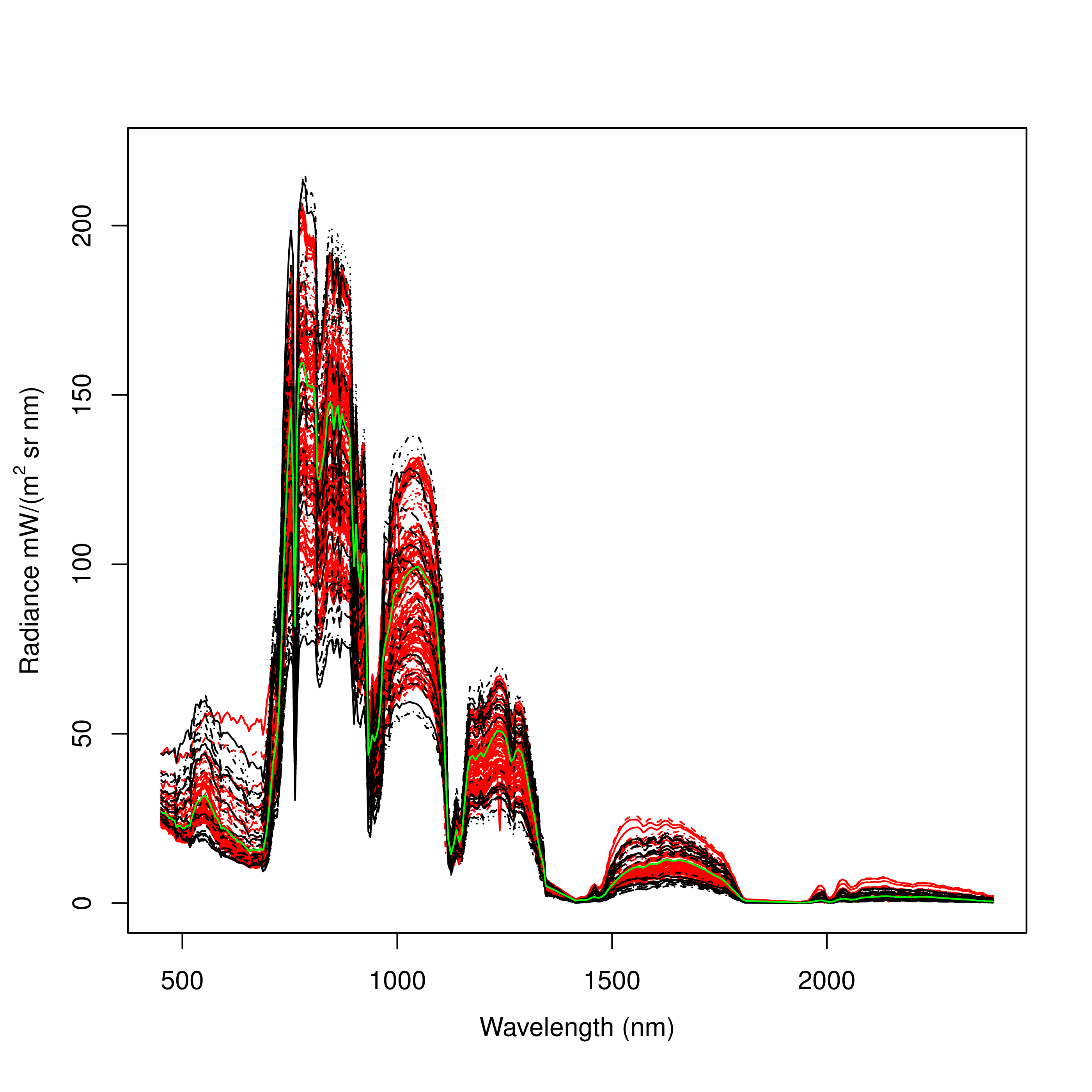
Measured at-sensor radiances (AISA dual) and simulated radiances of vegetation (wheat). red=at-sensor radiances, green=mean at-sensor radiances, black=simulated radiances. Preidl, S. A new framework for radiative transfer model inversion (in prep.)
Land-use classification, habitat & biodiversity mapping
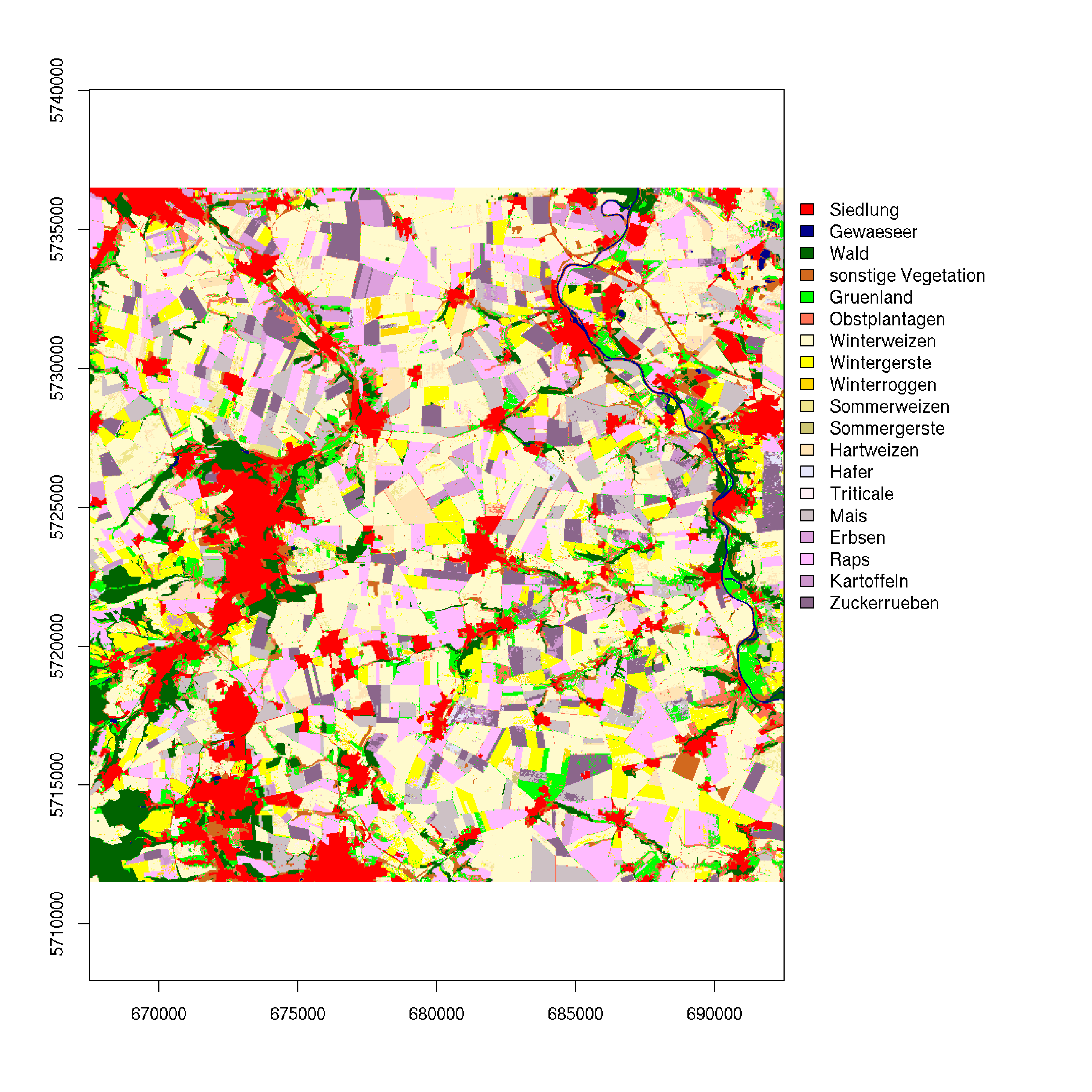
This is actually an old (remote sensing) topic which has seen a renaissance in the light of new satellite missions. This allows for example to discriminate tree species or to map crop types at field level (as shown below).
The link between pollination types at the community level and optical traits allows us to map spatial patterns of pollination types with remotely sensed hyperspectral data.
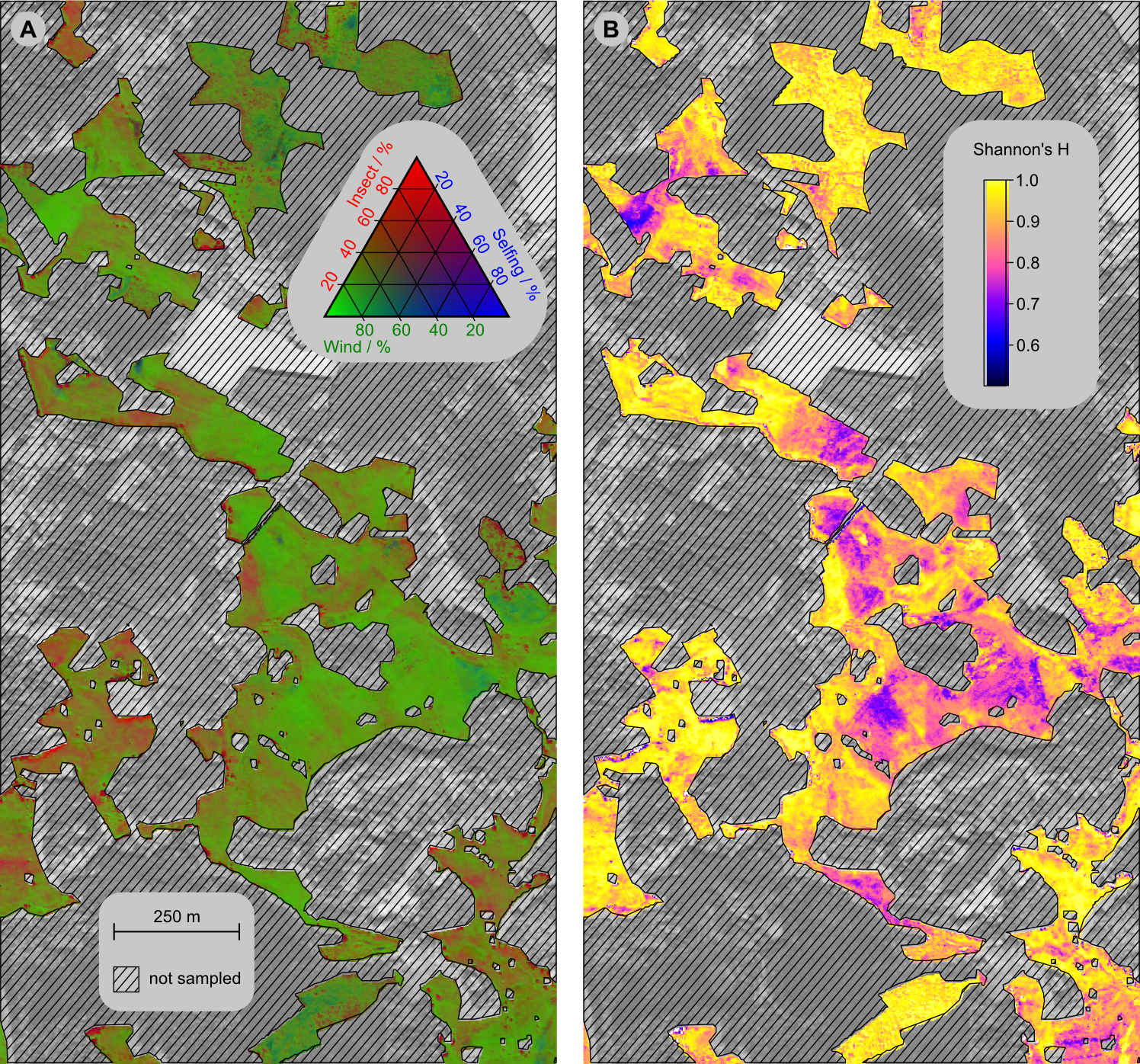
Distribution of the pollination types across the study site (a) and Shannon’s entropy H of the three pollination types (b) as mapped from airborne imaging spectroscopy data. Forested and agricultural areas were not covered by the sampling and thus masked. Feilhauer, H., Doktor, D., Schmidtlein, S., Skidmore, A. (2016). Mapping pollination types with remote sensing, Journal of Vegetation Science 27. pp. 999-1011
- Radiative transfer modelling (PROSAIL, SLC, DART)
- Machine learning (PCA, randomForest, PLSR, SVR, Gaussian processes), geostatistics
- Radiometric, geometric and atmospheric correction of hyperspectral data
- High performance cluster computation
Ongoing
- UFZ PhD colleg MoDEV, project "Assessment of species and trait diversity in temperate vegetation from optical remote sensing data". With Leipzig University, Prof. Feilhauer (2021-2024)
- Helmholtz Knowledge Transfer Project "Waldzustandsmonitor" (2021-2024)
Finished
- EU 'Ecopotential' ('Horizon 2020'). 'Derivation of bio-physical variables from remotely sensed imagery' (2015-2018)
- BMWi program ‚Vorbereitung der wissenschaftlichen und kommerziellen Nutzung der Sentinel-Missionen und nationalen Missionen‘: ‚PhenoS - Phänologische Strukturierung von zeitlich hochauflösenden Sentinel 2- Datensätzen zur Optimierung von Landnutzungsklassifikationen‘ (2013- 2017)
- Helmholtz-Alliance ‘Remote Sensing and Earth System Dynamics’ (Biosphere): 'Fusion of radar (L-band) and hyperspectral data to derive biomass, leaf area index and vegetation disturbance' (2012-2017)
- BfN assignement on ‚Characterisation of forest types using remotely sensed imagery‘ (2016)
- BMWi program ‚Vorbereitung der wissenschaftlichen und kommerziellen Nutzung der Sentinel-Missionen und nationalen Missionen‘: ‘Validierung von Sentinel-Produkten auf Basis kontinuierlicher spektraler und Eddy- Flux-Messungen’ (2012-2015)
- BMWi program ‚Development of methods and algorithms for data analysis in preparation of the EnMAP mission': ‘Methoden zur Ableitung des funktionellen Zusammenhanges ökosystemarer Prozesse in hyperspektralen Daten unterschiedlicher räumlicher Auflösung’ (2010- 2013)
- Project within ‚Ecosystem Services under Changing Land-use and Climate‘ (ESCALATE, http://www.ufz.de/escalate/): Ecosystem services assessment in a Central European floodplain forest: an ecosystem approach using reflective and thermal remote sensing data (2013-2016)
Integrated projects (IP, UFZ funded):
Within the topic 'From local scale processes to regional predictions' (T53) =>
- "Estimation of terrestrial gross primary production (GPP) from remote sensing data“ (2013-2017)
- "Modelling and measuring fluorescence of a deciduous forest" (2016-2019)
Bibliography
Doktor, D., Koslowsky, D., Lange, M., Seppelt, R., Badeck, F.W. (2017) ‚Disparate applicability of methods to extract phenological metrics and broad spatial satellite resolution affect computed trends of European spring phenology‘. Remote Sensing of Environment (submitted)Lange, M., Dechant, B., Rebmann, C., Vohland, M., Cuntz, M., Doktor, D. (2017) Establishment and Configuration of an Experimental Site for the Validation of Earth Observation Satellite Products - a Case Study on Phenology. Sensors (accepted)
Xu, X., Conrad, C., Doktor, D. (2017) Optimising Phenological Metrics Extraction for Different Crop Types in Germany Using the Moderate Resolution Imaging Spectrometer (MODIS). Remote Sensing , 9, 254.
Dechant, B., Cuntz, M., Vohland, M., Schulz, E., Doktor, D. (2017). Estimation of leaf photosynthesis traits from reflectance spectra: correlation to nitrogen content as dominating mechanism. Remote Sensing of Environment.
Gerstmann, H., Doktor, D., Gläßer C., Möller M. (2016). PHASE: A geostatistical model for the Kriging-based spatial prediction of crop phenology using public phenological and climatological observations. Computers and Electronics in Agriculture 127 (2016) pp. 726–738
Richter, R., Reu, B., Wirth, C., Doktor, D., Vohland, M. (2016). The use of airborne hyperspectral data for tree species classification ina species-rich Central European forest area. International Journal of Applied Earth Observation and Geoinformation 52 (2016). pp. 464–474
Lange, M., Schaber, J., Marx, A., Jäckel, G., Badeck, F.W., Seppelt, R., Doktor, D. (2016). Simulation of forest tree species' phenological phases for different climate scenarios: chilling requirements and photo-period may limit bud burst advancement". International Journal of Biometeorology. DOI 10.1007/s00484-016-1161-8
Feilhauer, H., Doktor, D., Schmidtlein, S., Skidmore, A. (2016). Mapping pollination types with remote sensing, Journal of Vegetation Science 27. pp. 999-1011
Carl G, Doktor D, Schweiger O, Kühn I (2016): Assessing relative variable importance across different spatial scales: a two-dimensional wavelet analysis. Journal of Biogeography (43) 2502–2512.
Luft, L., Neumann, C., Itzerott, S., Lausch, A., Doktor, D., Freude, M., Blaum, N., Jeltsch, F. (2016). Digital and real-habitat modeling of Hipparchia statilinus based on hyperspectral remote sensing data. INTERNATIONAL JOURNAL OF ENVIRONMENTAL SCIENCE AND TECHNOLOGY. 13 (1). pp. 187-200
Neumann, C., Weiss, G., Schmidtlein, S., Itzerott, S., Lausch, A., Doktor, D. and Brell, M. (2015), Gradient-Based Assessment of Habitat Quality for Spectral Ecosystem Monitoring, Remote Sensing 7(3), 2871-2898
Doktor, D., Lausch, A., Spengler, D., Thurner, M. (2014): Extraction of plant physiological status from hyperspectral signatures using machine learning methods. Remote Sensing 6 (12), 12247-12274.
Feilhauer, H., Dahlke, C., Doktor, D., Lausch, A., Schmidtlein, S., Schulz, G., Stenzel, S. Mapping the local variability of Natura 2000 habitats with remote sensing. Applied Vegetation Science 17 (4). 765–779
Brosinsky, A., Lausch, A., Doktor, D. et al. (2014) Analysis of Spectral Vegetation Signal Characteristics as a Function of Soil Moisture Conditions Using Hyperspectral Remote Sensing, JOURNAL OF THE INDIAN SOCIETY OF REMOTE SENSING 42 (2), 311-324
Lausch, A., Pause, M., Merbach, I., Zacharias, S., Doktor, D., Volk, M., Seppelt, R (2013): A new multiscale approach for monitoring vegetation using remote sensing-based indicators in laboratory, field, and landscape. ENVIRONMENTAL MONITORING AND ASSESSMENT 185 (2). 1215-1235
Carl, G., Doktor, D. and Kühn, I. (2012): Phase difference analysis of temperature and vegetation phenology for beech forest: a wavelet approach. Stochastic Environmental Research and Risk Assessment
Rogass, C., D. Spengler, M. Bochow, K. Segl, A. Lausch, D. Doktor, S. Roessner, R. Behling, H. U. Wetzel and H. Kaufmann (2011). Reduction of Radiometric Miscalibration-Applications to Pushbroom Sensors. Sensors 11(6): 6370-6395.
Doktor, D., Bondeau A., Koslowski D., Badeck F.W. (2009): Influence of heterogeneous landscapes on computed green-up dates based on daily AVHRR NDVI observations. Remote Sensing of Environment 113(12), p. 2618-2632
Badeck, F.-W., Böttcher, K, Bondeau, A., Doktor, D., Lucht, W., Schaber, J., Sitch, S. (2004). Responses of spring time phenology to climate change. New Phytologist 162, p. 295-309.
Index:
- 2024 (1)
- 2023 (1)
- 2022 (3)
- 2021 (1)
- 2020 (3)
- 2018 (1)
- 2017 (5)
- 2016 (6)
- 2015 (2)
- 2014 (3)
- 2013 (5)
- 2012 (1)
- 2011 (1)
- 2009 (1)
You could use our publication index for further requests.
2024 (1)
- Ludwig, A., Doktor, D., Feilhauer, H. (2024):
Is spectral pixel-to-pixel variation a reliable indicator of grassland biodiversity? A systematic assessment of the spectral variation hypothesis using spatial simulation experiments
Remote Sens. Environ. 302 , art. 113988 10.1016/j.rse.2023.113988
2023 (1)
- Mahecha, M.D., Bastos, A., Bohn, F., Eisenhauer, N., Feilhauer, H., Hickler, T., Kalesse-Los, H., Migliavacca, M., Otto, F.E.L., Peng, J., Tegen, I., Weigelt, A., Wendisch, M., Wirth, C., Al-Halbouni, D., Deneke, H.M., Doktor, D., Dunker, S., Ehrlich, A., Foth, A., García-García, A., Guerra, C.A., Guimarães- Steinicke, C., Hartmann, H., Henning, S., Herrmann, H., Ji, C., Kattenborn, T., Kolleck, N., Kretschmer, M., Kühn, I., Luttkus, M.L., Maahn, M., Mönks, M., Mora, K., Pöhlker, M., Reichstein, M., Rüger, N., Sánchez-Parra, B., Schäfer, M., Sippel, S., Tesche, M., Wehner, B., Wienecke, S., Winkler, A.J., Wolf, S., Zaehle, S., Zscheischler, J., Quaas, J. (2023):
Biodiversity and climate extremes: known interactions and research gaps
ESS Open Archive 10.22541/essoar.169462031.19744802/v1
2022 (3)
- Hase, N., Doktor, D., Rebmann, C., Dechant, B., Mollenhauer, H., Cuntz, M. (2022):
Identifying the main drivers of the seasonal decline of near-infrared reflectance of a temperate deciduous forest
Agric. For. Meteorol. 313 , art. 108746 10.1016/j.agrformet.2021.108746 - Lange, M., Feilhauer, H., Kühn, I., Doktor, D. (2022):
Mapping land-use intensity of grasslands in Germany with machine learning and Sentinel-2 time series
Remote Sens. Environ. 277 , art. 112888 10.1016/j.rse.2022.112888 - Ludwig, A.D., Doktor, D., Goss, R., Sasso, S., Feilhauer, H. (2022):
The leaf is always greener on the other side of the lab: Optical in-situ indicators for leaf chlorophyll content need improvement for semi-natural grassland areas
Ecol. Indic. 143 , art. 109424 10.1016/j.ecolind.2022.109424
2021 (1)
- Feilhauer, H., Zlinszky, A., Kania, A., Foody, G.M., Doktor, D., Lausch, A., Schmidtlein, S. (2021):
Let your maps be fuzzy!—Class probabilities and floristic gradients as alternatives to crisp mapping for remote sensing of vegetation
Remote Sens. Ecol. Conserv. 7 (2), 292 - 305 10.1002/rse2.188
2020 (3)
- Ayalew, D.A., Deumlich, D., Šarapatka, B., Doktor, D. (2020):
Quantifying the sensitivity of NDVI-based C factor estimation and potential soil erosion prediction using spaceborne Earth observation data
Remote Sens. 12 (7), art. 1136 10.3390/rs12071136 - Kattge, J., Bönisch, G., Díaz, S., Lavorel, S., Beckmann, M., Dechant, B., Durka, W., Klotz, S., Roscher, C., Doktor, D., Prentice, I.C., et al. (2020):
TRY plant trait database – enhanced coverage and open access
Glob. Change Biol. 26 (1), 119 - 188 10.1111/gcb.14904 - Preidl, S., Lange, M., Doktor, D. (2020):
Introducing APiC for regionalised land cover mapping on the national scale using Sentinel-2A imagery
Remote Sens. Environ. 240 , art. 111673 10.1016/j.rse.2020.111673
2018 (1)
- Rocchini, D., Luque, S., Pettorelli, N., Bastin, L., Doktor, D., Faedi, N., Feilhauer, H., Féret, J.-B., Foody, G.M., Gavish, Y., Godinho, S., Kunin, W.E., Lausch, A., Leitão, P.J., Marcantonio, M., Neteler, M., Ricotta, C., Schmidtlein, S., Vihervaara, P., Wegmann, M., Nagendra, H. (2018):
Measuring β-diversity by remote sensing: A challenge for biodiversity monitoring
Methods Ecol. Evol. 9 (8), 1787 - 1798 10.1111/2041-210X.12941
2017 (5)
- Dechant, B., Cuntz, M., Vohland, M., Schulz, E., Doktor, D. (2017):
Estimation of photosynthesis traits from leaf reflectance spectra: Correlation to nitrogen content as the dominant mechanism
Remote Sens. Environ. 196 , 279 - 292 10.1016/j.rse.2017.05.019 - Lange, M., Dechant, B., Rebmann, C., Vohland, M., Cuntz, M., Doktor, D. (2017):
Validating MODIS and Sentinel-2 NDVI products at a temperate deciduous forest site using two independent ground-based sensors
Sensors 17 (8), art. 1855 10.3390/s17081855 - Padró, J.-C., Pons, X., Aragonés, D., Díaz-Delgado, R., García, D., Bustamante, J., Pesquer, L., Domingo‐Marimon, C., González-Guerrero, O., Cristóbal, J., Doktor, D., Lange, M. (2017):
Radiometric correction of simultaneously acquired Landsat-7/Landsat-8 and Sentinel-2A imagery using Pseudoinvariant Areas (PIA): Contributing to the Landsat time series legacy
Remote Sens. 9 (12), art. 1319 10.3390/rs9121319 - Schröter, I., Paasche, H., Doktor, D., Xu, X., Dietrich, P., Wollschläger, U. (2017):
Estimating soil moisture patterns with remote sensing and terrain data at the small catchment scale
Vadose Zone J. 16 (10) 10.2136/vzj2017.01.0012 - Xu, X., Conrad, C., Doktor, D. (2017):
Optimising phenological metrics extraction for different crop types in Germany using the Moderate Resolution Imaging Spectrometer (MODIS)
Remote Sens. 9 (3), art. 254 10.3390/rs9030254
2016 (6)
- Carl, G., Doktor, D., Schweiger, O., Kühn, I. (2016):
Assessing relative variable importance across different spatial scales: a two-dimensional wavelet analysis
J. Biogeogr. 43 (12), 2502 - 2512 10.1111/jbi.12781 - Feilhauer, H., Doktor, D., Schmidtlein, S., Skidmore, A.K. (2016):
Mapping pollination types with remote sensing
J. Veg. Sci. 27 (5), 999 - 1011 10.1111/jvs.12421 - Gerstmann, H., Doktor, D., Gläßer, C., Möller, M. (2016):
PHASE: A geostatistical model for the Kriging-based spatial prediction of crop phenology using public phenological and climatological observations
Comput. Electron. Agric. 127 , 726 - 738 10.1016/j.compag.2016.07.032 - Lange, M., Schaber, J., Marx, A., Jäckel, G., Badeck, F.W., Seppelt, R., Doktor, D. (2016):
Simulation of forest tree species’ bud burst dates for different climate scenarios: chilling requirements and photo-period may limit bud burst advancement
Int. J. Biometeorol. 60 (11), 1711 - 1726 10.1007/s00484-016-1161-8 - Luft, L., Neumann, C., Itzerott, S., Lausch, A., Doktor, D., Freude, M., Blaum, N., Jeltsch, F. (2016):
Digital and real-habitat modeling of Hipparchia statilinus based on hyper spectral remote sensing data
Int. J. Environ. Sci. Technol. 13 (1), 187 - 200 10.1007/s13762-015-0859-1 - Richter, R., Reu, B., Wirth, C., Doktor, D., Vohland, M. (2016):
The use of airborne hyperspectral data for tree species classification in a species-rich Central European forest area
Int. J. Appl. Earth Obs. Geoinf. 52 , 464 - 474 10.1016/j.jag.2016.07.018
2015 (2)
- Lausch, A., Salbach, C., Schmidt, A., Doktor, D., Merbach, I., Pause, M. (2015):
Deriving phenology of barley with imaging hyperspectral remote sensing
Ecol. Model. 295 , 123 - 135 10.1016/j.ecolmodel.2014.10.001 - Neumann, C., Weiss, G., Schmidtlein, S., Itzerott, S., Lausch, A., Doktor, D., Brell, M. (2015):
Gradient-based assessment of habitat quality for spectral ecosystem monitoring
Remote Sens. 7 (3), 2871 - 2898 10.3390/rs70302871
2014 (3)
- Brosinsky, A., Lausch, A., Doktor, D., Salbach, C., Merbach, I., Gwillym-Margianto, S., Pause, M. (2014):
Analysis of spectral vegetation signal characteristics as a function of soil moisture conditions using hyperspectral remote sensing
J. Indian Soc. Remote Sens. 42 (2), 311 - 324 10.1007/s12524-013-0298-8 - Doktor, D., Lausch, A., Spengler, D., Thurner, M. (2014):
Extraction of plant physiological status from hyperspectral signatures using machine learning methods
Remote Sens. 6 (12), 12247 - 12274 10.3390/rs61212247 - Feilhauer, H., Dahlke, C., Doktor, D., Lausch, A., Schmidtlein, S., Schulz, G., Stenzel, S. (2014):
Mapping the local variability of Natura 2000 habitats with remote sensing
Appl. Veg. Sci. 17 (4), 765 - 779 10.1111/avsc.12115
2013 (5)
- Brell, M., Rogass, C., Segl, K., Spengler, D., Kuester, T., Itzerott, S., Chabrillat, S., Roessner, S., Lausch, A., Doktor, D., Kaufmann, H. (2013):
An automated pre-processing chain for airborne hyperspectral data including radiometric calibration, atmospheric correction and direct georeferencing
Conference: 8th EARSeL SIG Imaging Spectroscopy Workshop Nantes, France
10.13140/2.1.2932.1604 - Carl, G., Doktor, D., Koslowsky, D., Kühn, I. (2013):
Phase difference analysis of temperature and vegetation phenology for beech forest: a wavelet approach
Stoch. Environ. Res. Risk Assess. 27 (5), 1221 - 1230 10.1007/s00477-012-0658-x - Lausch, A., Pause, M., Doktor, D., Preidl, S., Schulz, K. (2013):
Monitoring and assessing of landscape heterogeneity at different scales
Environ. Monit. Assess. 185 (11), 9419 - 9434 10.1007/s10661-013-3262-8 - Lausch, A., Pause, M., Merbach, I., Zacharias, S., Doktor, D., Volk, M., Seppelt, R. (2013):
A new multiscale approach for monitoring vegetation using remote sensing-based indicators in laboratory, field, and landscape
Environ. Monit. Assess. 185 (2), 1215 - 1235 10.1007/s10661-012-2627-8 - Lausch, A., Zacharias, S., Dierke, C., Pause, M., Kühn, I., Doktor, D., Dietrich, P., Werban, U. (2013):
Analysis of vegetation and soil patterns using hyperspectral remote sensing, EMI, and gamma-ray measurements
Vadose Zone J. 12 (4) 10.2136/vzj2012.0217
2012 (1)
- Doktor, D., Lange, M., Koslowsky, D. (2012):
Evaluation of methods to compute green-up dates based on daily NDVI observations
2012 IEEE 32nd International Geoscience and Remote Sensing Symposium, Munich, Germany, 22-27 July 2012
International Geoscience and Remote Sensing Symposium IGARSS2012
Institute of Electrical and Electronics Engineers (IEEE), New York, NY, p. 4922 - 4925 10.1109/IGARSS.2012.6352508
2011 (1)
- Rogass, C., Spengler, D., Bochow, M., Segl, K., Lausch, A., Doktor, D., Roessner, S., Behling, R., Wetzel, H.-U., Kaufmann, H. (2011):
Reduction of radiometric miscalibration-applications to pushbroom sensors
Sensors 11 (6), 6370 - 6395 10.3390/s110606370
2009 (1)
- Doktor, D., Bondeau, A., Koslowski, D., Badeck, F.-W. (2009):
Influence of heterogeneous landscapes on computed green-up dates based on daily AVHRR NDVI observations
Remote Sens. Environ. 113 (12), 2618 - 2632 10.1016/j.rse.2009.07.020
