Saale River Basin


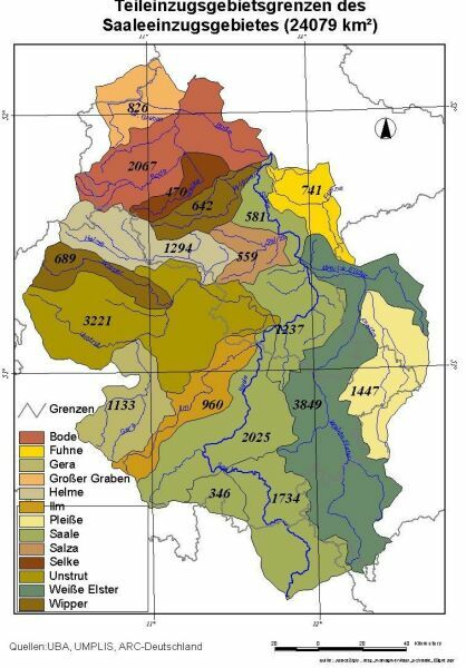
The Saale River is one of the main tributaries of the Elbe River located in Central Europe. Nearly the whole Saale drainage basin is located in Germany. In general, the German part of the Elbe drainage area is subdivided into three typical sub-regions based on relief and soils: the Pleistocene lowland, the loess sub-region and the mountainous sub-region. The Saale basin covers large parts of the loess and mountainous sub-regions. The length of the Saale River is about 320 km and the drainage basin area is about 24,000 km². The main tributaries of the Saale are the Unstrut, the Weiße Elster and the Bode. The basin includes the cities of Leipzig, Halle, Erfurt, Gera and Jena. Topography of the basin is heterogeneous with elevation varying between 50 m a.s.l. and about 1100 m a.s.l. Highland areas are represented by the Harz Mountains and the Thueringer Wald.
The long-term mean annual precipitation in the Saale basin is about 700 mm/yr. The long-term mean discharge of the Saale River is 115 m³ s-1 at the mouth and the specific discharge is 4.85 l s-1 km-2 which corresponds to the mean annual discharge of 3.63 ×10⁹ m³. The river discharge is characterised by winter and spring high water periods. There are several regulating reservoirs in the upper part of the basin.
Nutrient pollution (nitrogen and phosphorus) is one of the most widespread forms of water pollution in the basin. Agriculture land occupies over 60% of the total Saale drainage area with its very productive loess soils and represents the most important source of diffuse nitrogen pollution.
The Saale and its tributaries are intensively used for fresh water supply for domestic, industrial and agricultural purposes. Though since the beginning of the nineties the emissions from point sources were notably decreased in the basin due to closing of some industries, reduction of others and introduction of new and better sewage treatment facilities, the diffuse sources of pollution represented mainly by agriculture are still not sufficiently controlled.
(Source: own studies and Krysanova, V., Haberlandt, U., 2002. Assessment of nitrogen leaching from arable land in large river basins. Part I. Simulation experiments using a process-based model. Ecological Modelling 150, 255-275.)
Project:
Integrated river basin management on the example of the Saale River
Duration: 2001 bis 2004. Project homepage
Head of subproject: "TP1 : Water and nutrient balance and land use": Dr. Martin Volk
Objectives of the present studies in the Saale river basin:
- Investigations od model sensitivity and simulation of the impact of land use changes on water quantity and quality using different model systems (SWAT, SME and others).
- Investigation of the development of agricultural land management in the river basin by using agricultural statistics, remote sensing and scenarios of future land use development
- Investigation of catchment-related control on runoff components (streamflow, baseflow)
- Development of databased models
- Development of a comprehensive river basin database
Contact: Prof. Dr. Martin Volk , Dr. Luis Samaniego, Prof. Dr. Ralf Seppelt
Former colleague: Dr. Gerd Schmidt, Dr. Karsten Schulz
